It's the calm before the storm as a chilly rain will continue to fall through this morning into the afternoon hours, but an arctic front is approaching our area. The front will arrive later today, dropping temperatures below freezing across the region by midnight tonight.
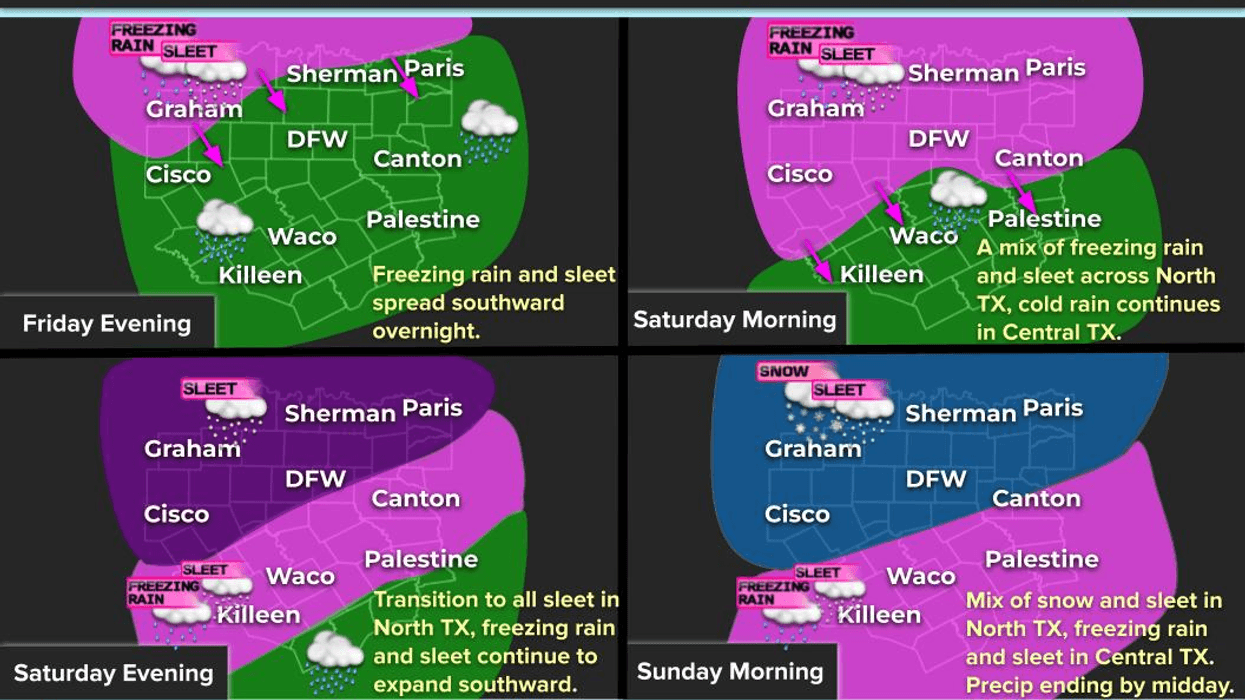
Good morning, everyone. I believe it's Friday. LOL. You have until dinner time to finalize preparations for the impending winter storm. If you're heading to work or school this morning, be sure to bring an umbrella, a fleece-lined jacket, hat, and gloves. The chilly rain will continue to spread across North Texas throughout the morning and afternoon. I would like to emphasize that this will be a cold rain.
Temperatures will fall through the 40s this morning and into the 30s this afternoon. Readings will drop below freezing from northwest to southeast between 6:00 p.m. and 3:00 a.m. on Saturday. This will cause the cold rain to transition to freezing rain and eventually to sleet from northwest to southeast through the early morning hours. The sleet will accumulate not just on bridges and overpasses, but on all roads by daybreak on Saturday.
Temperatures will continue to drop throughout the day on Saturday, reaching the upper teens to low 20s by Saturday evening. A wave of heavy, accumulating sleet with possible thunder will move across the area between 6:00 a.m. and noon on Saturday. Waves of lighter sleet will continue to pass through the area during the afternoon.
As the main upper-level disturbance approaches on Saturday evening, another wave of heavy, accumulating sleet with embedded thunder will move across the area, severely impacting roadways across North Texas.
By daybreak on Sunday, temperatures will have fallen into the low to mid-teens, with a transition from sleet to snow working its way in from the west. This is when everyone can expect 2 to 4 inches of snow, with the heaviest totals towards the Red River and northwest of Fort Worth. The accumulating snow will move east of the area by early afternoon, but snow flurries will continue throughout the day. Temperatures will struggle to rise above 20°F.
An interesting phenomenon may occur on Sunday afternoon into early evening, as areas on the south side of north-south oriented lakes could experience a burst of an additional 1 to 2 inches of snow.
With clear skies and calm winds, Monday morning lows will dip between 0 and 5°F. Be prepared for pipe bursts and icy weather. Monday will be sunny but chilly, with afternoon highs in the mid-to-upper 20s. Some melting will occur on roadways, but it will rapidly refreeze after sunset on Monday evening.
Tuesday morning will be back in the single digits to low teens, with areas of black ice and possibly cobblestone ice on untreated roadways. Tuesday will be sunny, with temperatures reaching 35°F by the afternoon.
Wednesday and Thursday will remain chilly, with lows in the 20s and afternoon highs approaching 40°F. There will be some patchy ice around during the mornings.
As of now, it appears that another arctic front may arrive by the end of next week into the following weekend. However, it's still too early to discuss precipitation that far out. Stay tuned.
Have a great day today, and enjoy the weather when you can, it's the only weather you've got.
7-Day Headlines:
* DFW Airport reached 53 yesterday
* Still time to prepare for storm until Friday early evening
* Winter Storm Warning: Friday 6pm – Sunday noon
* Extreme Cold Warning: Saturday 6pm –Monday noon
* Friday morning Arctic cold front. Cold rain through the early evening
* Rain to freezing rain to sleet Friday evening into Saturday morning
* Lots of accumulating sleet on Saturday into early Sunday
* Morning Sunday snow, then flurries throughout the day
* 1" to 5" of Snow/Sleet (heaviest N and NW of DFW); 1/8"to 3/4" of ice (heaviest SE of DFW)
* Sub freezing temperatures Friday evening through Tuesday afternoon
*Yest Rain: 0.00"; Yest High: 53; Low: 39
*Today's Averages: High: 57; Low: 36
*Record high: 88 (1943); Record low: 9 (1966)
*January Rain: 0.02"; Deficit:
*2026 Rain: 0.02"; Deficit:
*Sunrise: 7:28am; Sunset: 5:53pm
Friday: Cloudy, turning windy and colder. COLD rain picks up through the day. Windy. High: Low 50s early, falling into the 30s by afternoon. Wind: North 15-25 mph.
Friday night: Cloudy, windy and VERY cold. Cold rain to accumulating freezing rain to sleet before daybreak. Low: Low to mid 20s. Wind chills: Single digits. Wind: North 15-25, G30 mph.
Saturday: Cloudy, windy and VERY cold. Morning HEAVY accumulating sleet with thunder possible. Lighter afternoon sleet. High: Falling through the 20s. Wind chills: Single digits. Wind: North 15-25 mph.
Saturday night: Cloudy, windy and cold. Accumulating HEAVY sleet returns, changing to accumulating snow by daybreak. Low: Low to mid teens. Wind chills: below zero.
Sunday: Morning accumulating snow, then snow flurries throughout the day. High: Low 20s.
Monday: A bitter cold morning, then mostly sunny and continued cold. Lighter wind. Low: Single digits; High: Mid to upper 20s.
Tuesday: Another pipe bursting morning, then mostly sunny and cold. FINALLY above freezing. Low: Single digits to low teens. High: Mid 30s.
Wednesday: Partly cloudy and chilly. Low: Teens; High: Near 40.
Thursday: Mostly cloudy and chilly. Low: 20s; High: High 40.
LISTEN on the Audacy App
Tell your Smart Speaker to "PLAY 1080 KRLD"
Sign Up to receive our KRLD Insider Newsletter for more news
Follow us on Facebook | Twitter | Instagram | YouTube