Quiet through the first half of Saturday, and then the first of a few weather changes will slowly unfold across North Texas between now and the end of the month. It is October, but it's been very quiet the first half of the month.
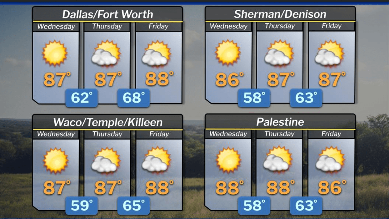
Good morning, ladies and gentlemen. As you step out the door this morning, you've probably noticed that temperatures are a little bit cooler. Readings are in the upper 50s to mid-60s across North Texas. We've had some dry air sneak in from the East over the past 24 hours. That combined with a clear sky and calm wind has allowed temperatures to cool off pretty quickly overnight. Plenty of sunshine is in store for us today with afternoon highs in the mid to upper 80s. A gentle breeze will be blowing from the East.
The upper-level ridge of high pressure will continue to dominate our area through Saturday afternoon. Temperatures will continue to be well above average with afternoon highs in the mid to upper 80s through Friday, and near 90 on Saturday. Morning lows will dip into the 60s with no rain and plenty of sunshine. The wind will pick up Friday through the weekend and actually shift directions from the south to the north by Sunday morning.
I'll be keeping my eye on Saturday afternoon into the early evening hours as the dryline in West Texas may spark a couple of strong thunderstorms across North Texas. It all depends on if our cap breaks. The bulk of the severe weather will be in eastern Oklahoma, all of Arkansas, western Tennessee, and the northern parts of Louisiana, Mississippi, and Alabama late Saturday and early Sunday.
Our biggest story through Sunday will be a cold front that'll move through during the morning hours. Wind will shift to the north and gusts to 20 mph throughout the day. Cool, dry air will filter in from the northern plains states as we struggle to hit 80° on Sunday. That will actually be three degrees above average for this time of the year, but it'll feel a heck of a lot nicer for the last day of the State Fair of Texas.
Sunshine will dominate next Monday and Tuesday with morning lows dipping into the 50s in some areas on Monday morning. Afternoon highs will reach the mid-80s, low 80s on Tuesday behind a second weak dry front. Weather models are trending towards another weather change by the end of next week into the following weekend. We may see a bit more rain around the area and much cooler temperatures. This is a trend I will watch through next week.
Thank you for following my page, have a great day, and enjoy the weather when you can, it's the only weather you've got!
7-Day Headlines:
DFW hit 88 degrees on Tuesday.
Mornings are a bit cooler. Afternoons are warm and dry.
No rain at DFW for the past 19 days.
Staying warm through Saturday.
Slight rain chance on Saturday.
Cold front Sunday morning, Upper 70s for highs!!
*Yest Rain: 0.00"; Yest High: 88 Low: 67
*Today's Averages: High: 79; Low: 57
*Record high: 95 (2015); Record low: 41 (2018)
*October Rain: 0.00"; Deficit:
*2025 Rain: 28.16"; Deficit: 0.80"
*Sunrise: 7:33am; Sunset: 6:53pm
Wednesday: Mostly sunny and warm. High: Mid to upper 80s. Wind: East 5-10 mph.
Wednesday night: Clear and pleasant. Low: 60-65. Wind: E 5 mph.
Thursday: Partly cloudy and warm. High: Mid to upper 80s. Wind: SE 10-20 mph.
Friday: Mostly sunny, breezy, and warm. High: Mid to upper 80s.
Saturday: Increasing clouds, breezy, continued warm. Slight chance of late afternoon and early evening showers and storms (north of I-20; east of I-35W). High: Near 90.
Sunday: Sunny, breezy and refreshing! High: Upper 70s.
Monday: Mostly sunny and warmer. High: Mid 80s.
Tuesday: Mostly sunny and nice. Another weak cold front. High: Low 80s.
LISTEN on the Audacy App
Tell your Smart Speaker to "PLAY 1080 KRLD"
Sign Up to receive our KRLD Insider Newsletter for more news
Follow us on Facebook | Twitter | Instagram | YouTube