


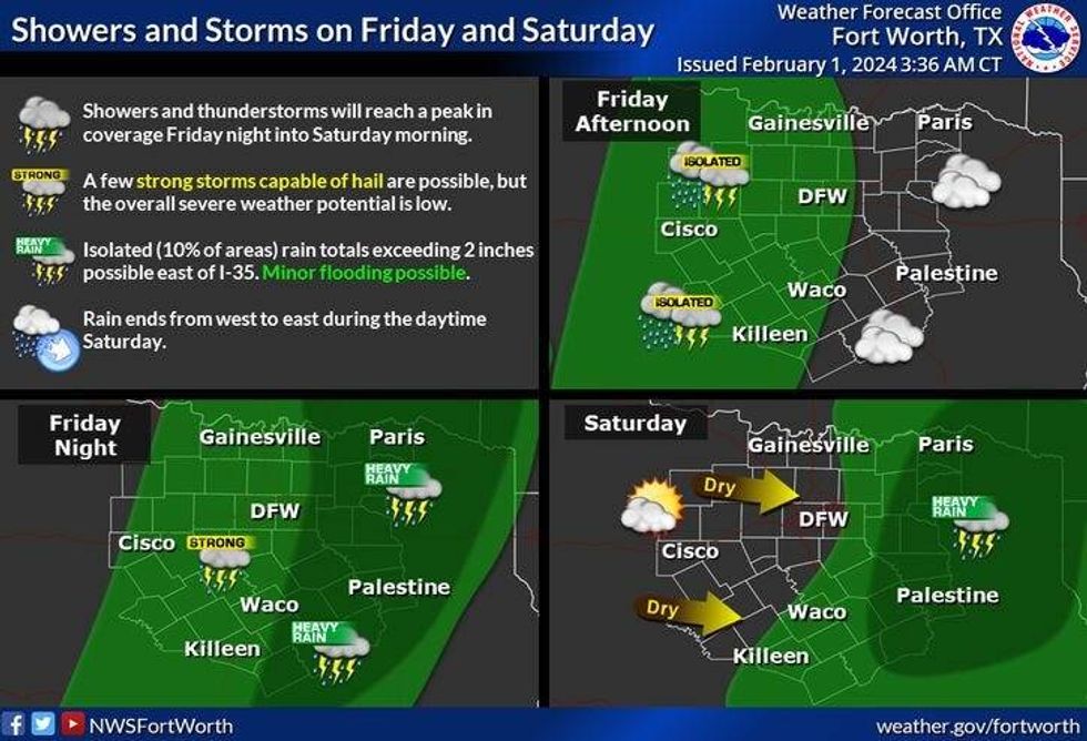
Three days in a row with temperatures in the 70s, and we'll add another day or two to that before we cool off late into the weekend into early next week. Plus, we have widespread showers and thunderstorms that will be moving into the area late tomorrow through Saturday morning. A few strong storms are possible with small hail and gusty wind.
But first, we get to enjoy another beautiful day today. We're starting off in the 40s this morning with some mid-level clouds rolling through the area. A weak upper level disturbance will cross the area this morning. We're also getting a few sprinkles being reported NW of DFW. These will pass to our north and won't amount to much. Plenty of sunshine today with highs back in the low to mid 70s. A south wind will pick up and gust to 25 mph.
Increasing clouds tonight, breezy and mild. Low temperatures in the low to mid 50s.
 National Weather Service - Fort Worth
Tomorrow will be mostly cloudy, breezy, and mild again with highs near 70°. Scattered showers will move into the area tomorrow afternoon, but the widespread rain arrives after dark, lasting through the overnight and ending from west to east by noon Saturday. As stated above, a few strong storms are possible, but the overall severe weather threat is low. Most of you will pick up a half inch of rain with isolated higher totals in areas.
Decreasing clouds by Saturday afternoon but continued mild. Afternoon highs will top out in the mid to upper 60s.
A cold front will blow through the area Sunday morning. Winds will shift to the north and gust to 30 mph as clouds roll back in from the north. Afternoon highs will top out in the low 60s. There may even be a few sprinkles the second half of Sunday into early Monday morning.
Plenty of sunshine, low humidity, and comfortable temperatures are in store Monday through Wednesday. Highs on Monday and Tuesday will be near the mid-60s.
*Yest Rain: 0.00"; Yest High: 76 Low: 43
*Today's Averages: High: 59; Low: 37
*Record high: 91 (1911); Record low: 6 (1951)
*January Rain: 3.20"; Surplus: 0.67"
*2024 Rain: 3.20"; Surplus: 0.67"
*Sunrise: 7:23am; Sunset: 6:00pm
LISTEN on the Audacy App
Tell your Smart Speaker to "PLAY 1080 KRLD"
Sign Up to receive our KRLD Insider Newsletter for more news
Follow us on Facebook | Twitter | Instagram | YouTube


