We only topped out at 89°! And we're a little cooler this morning as well behind a weak frontal boundary that is parked just south of DFW.
Temperatures are a bit cooler this morning, 60s along the Red River counties, low 70s elsewhere. Pockets of morning clouds and afternoon sunshine today with highs in the middle 90s. Heat index values will be near 100°. There's also a very slight chance for a shower or storm to our SE today, but chances are slim.
 National Weather Service - Fort Worth
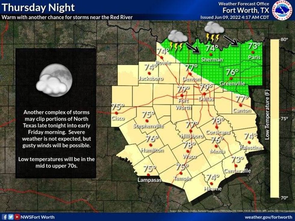
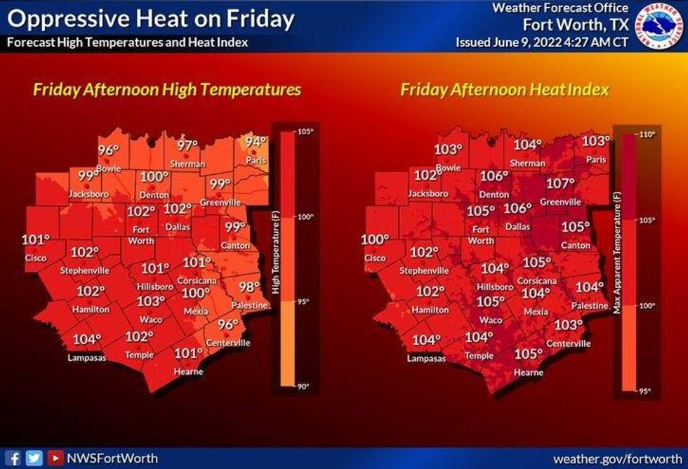
For tonight, increasing clouds out ahead of an upper-level disturbance that will bring showers and storms relatively close to DFW before sunrise tomorrow. As of now, it looks like the majority of the rain will stay north of the Red River. Gusty wind will be the main threat. This area of storms will weaken as it moves off to our northeast by mid-morning. Clouds will erode away by afternoon with near record-breaking heat. Afternoon highs will approach 101 degrees. That would tie the record for the day. Heat index values will range between 105 and 108 degrees. Please make sure you stay hydrated if you'll be working outdoors.
This upper level ridge of high pressure, that's been parked in west Texas, will start to head our direction this weekend and then shift slightly east of DFW by mid-week next week. This being said, our hottest days will be on Sunday and Monday. We'll still warm to near 100° on Saturday, hotter than that out west of Fort Worth. Sunday and Monday we'll be flirting with record high temperatures again. Readings will top out between 102 and 104 degrees.
 National Weather Service - Fort Worth
The center of the upper-level high will shift to our east by Tuesday and Wednesday, shaving a few degrees off the temperatures. Readings will settle to near 100 degrees.
Just think, summer is still 12 days away and it's already feeling like it with these well above average temperatures.
*Yest Rain: 0.00"; *Yest High: 89; Low: 76
*Today's Averages: High: 91; Low: 71
*Record high: 102 (1911); Record low: 59 (1955, 1978)
* June rain: 2.64"; June surplus: +1.57"
*2022 rain: 12.41"; 2022 deficit: 5.25"
*Sunrise: 6:19am; Sunset: 8:36pm
Today: Partly cloudy, hot and humid. Slight chance of afternoon storms southeast of Dallas. High: Mid 90s. Heat index near 100. Wind: Variable 5-10 mph.
Tonight: Partly cloudy and muggy. Low: Mid to upper 70s. Wind: ESE 5-10 mph.
Tomorrow: Slight chance of early morning showers and storms. Decreasing clouds, hot and humid. Near record highs (Record is 101). High: 98-102. Heat index near 105. Wind: SW 10-20 mph.
Saturday: Sunny and hot. High: 99-103. Heat index near 105
Sunday and Monday: Sunny, breezy, and hot. Near record heat. Less humidity. Highs: 100-104.
Tuesday and Wednesday: Sunny, breezy and continued hot. High: Near 100.

LISTEN on the Audacy App
Sign Up and Follow NewsRadio 1080 KRLD