


It's still severe weather season and there's a threat for isolated storms today, but especially tomorrow and Thursday. All modes of severe weather are possible as well as areas of flooding.
We hit 91° Monday. We also hit that number on Saturday and Sunday. Why not hit it again today? Right? We'll get the morning clouds out of here this morning and I'm expecting plenty of sunshine today, with a strong breeze and plenty of humidity. I can't rule out a late-day shower or storm mainly west of DFW. If any do break the cap, it will go severe quickly. Good news is they'll be few and far between.
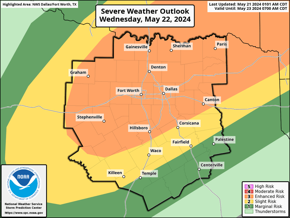
Wednesday and Thursday could get pretty dicey around here. A cold front will sag into the area tomorrow afternoon and evening producing scattered storms. Some of these will become severe with hail, wind, and an isolated tornado in areas. Not everyone will see severe storms. Afternoon highs will top out near 90°.
 NWS
NWS
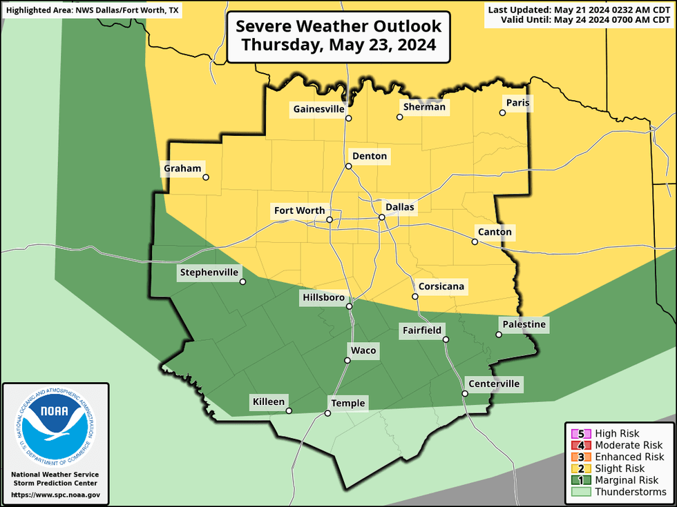
This front will start to lift back to the north on Thursday. Right now, I think the best chance for severe storms, scattered in nature, will be a long and north of Interstate 20. Hail and wind will be the threats on Thursday as well as heavy rain with some flooding due to the saturated ground. Afternoon highs will top out in the mid 80s... if we're lucky.
 NWS
NWS
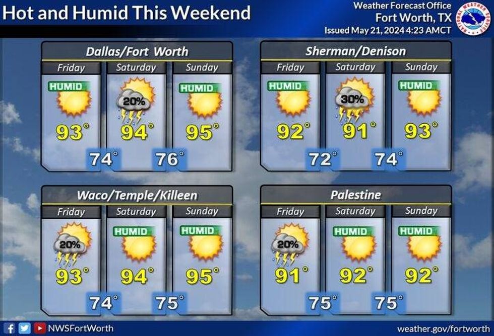
Friday and Saturday will be mainly dry as we heat back up into the low '90s. I can't rule out a late day storm each afternoon and evening, however most of you will stay dry.
Sunday will be hot, beezy and humid ...with afternoon highs in the mid 90s. Heat index values will be above 100°.
 NWS
NWS
Extended data is showing a cold front possibly moving through the area on Memorial Day. It's still too early to tell if it will produce any storms, but I will definitely keep you posted. Afternoon highs will be near 90°. Much cooler next Tuesday!
Have a terrific day everyone, please stay weather aware especially on Wednesday and Thursday, and also.... don't forget to enjoy the weather when you can, it's the only weather you've got!
_____________________
7-Day Headlines:
* DFW Airport reached 91 yesterday.
* Near 90 degrees today and Wednesday.
* Slight storm chance (west of DFW) this evening.
* Scattered strong and severe storms Wednesday and Thursday.
* All msdes of severe weather are possible.
* A hot and humid holiday weekend ahead. A few late day storms Friday & Saturday.
_____________________________________________________
*Yest Rain: 0.00"; Yest High: 91; Low: 73
*Today's Averages: High: 85; Low: 66
*Record high: 99 (2005) Record low: 51 (1947)
_________________________________________________________
*May Rain: 3.72"; Surplus: 0.60"
*2024 Rain: 20.99"; Surplus: 6.06"
*Sunrise: 6:25am; Sunset: 8:25pm
_________________________________________________________
Today: Morning clouds, afternoon sun. Windy and warm. An isolated strong storm "west" of DFW. High: Near 90. Wind: South 10-20, G30 mph.
Tonight: Increasing low clouds. Mild and muggy. Low: Low to mid 70s. Wind: South 15-25 mph.
Tomorrow: Morning clouds, afternoon sun. Breezy and warm. Scattered afternoon & evening storms. Some severe. Threats: Large hail, damaging wind and an isolated tornado. High: Near 90. Wind: South 10-20, G30 mph.
Thursday: Morning clouds, some afternoon sun. Scattered afternoon and evening storms. Some may become severe. High: Mid 80s.
Friday: Partly cloudy and warm. A few late day storms. High: Low 90s.
Weekend: Mostly sunny, windy, hot and humid. A few afternoon and evening storms. Highs: Low to mid 90s.
Memorial Day: Partly cloudy, windy, hot, and humid. High: Near 90.
LISTEN on the Audacy App
Tell your Smart Speaker to "PLAY 1080 KRLD"
Sign Up to receive our KRLD Insider Newsletter for more news
Follow us on Facebook | Twitter | Instagram | YouTube


