We are waking up to temperatures in the fifties this morning under a clear sky, so a light jacket will be necessary. Plenty of sunshine today and tomorrow with highs in the low to mid seventies. Perfect weather.
By the way - did you get any hail yesterday?
Quarters: Alvarado, North Dallas, Euless, Rowlett, Grandview
Ping pong: Rockwall, Richardson, Crandall, North Dallas
Teacup: Plano
Baseball: Crandall
Don't let your guard down. Clouds will rapidly increase Saturday night, with a good chance of chilly rain on Sunday.
A strong cold front will move through the area Saturday night dropping temperatures into the fifties for highs on Sunday. Windchills will be in the forties.
 National Weather Service - Fort Worth
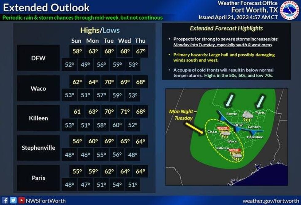
It will remain cool on Monday, with highs near 60 degrees. Plus, scattered showers will dot the area. Mid to upper sixties on Tuesday, with another wave of moderate to heavy rain by evening, and then morning showers, afternoon sunshine on Wednesday, as another cold front comes through during the early morning hours. Afternoon highs will only be in the mid sixties with clearing skies. It will remain cool on Thursday with highs in the mid sixties.
Quite a weather change ahead for late April, but we definitely need the rain. Our rainfall deficit is right around an inch for the year, but that will be erased by the middle of next week.
*Yest Rain: 0.94"; Yest High: 85 Low: 62
*Today's Averages: High: 77; Low: 57
*Record high: 95 (1925); Record low: 37 (2021)
*April Rain: 1.54"; Deficit: 0.47"
*2023 Rain: 9.65"; Deficit: 0.95"
*Sunrise: 6:52am; Sunset: 8:03pm
Today: Mostly sunny and perfect today. High: Low to mid 70s. Wind: NE 10-20 mph.
Tonight: Fair and chilly. Low: 48-52. Wind: Lt. Var.
Tomorrow: Increasing clouds by late afternoon. Seasonable temperatures. Strong cold front by late evening. High: Low to mid 70s. Wind: SE 5-10 mph.
Sunday: Cloudy and cool. A widespread chilly rain. (1"- 1.5"). Much colder. Highs: Low to mid 50s.
Monday: Cloudy and cool. Scattered showers. High: Near 60.
Tuesday: Mostly cloudy and cool. Scattered showers and isolated non-severe storms. High: Upper 60s.
Wednesday: Morning rain/cold front, then decreasing clouds, breezy and cool. High: Mid 60s.
Thursday: Sunny and cool. High: Low to mid 60s.

LISTEN on the Audacy App
Tell your Smart Speaker to "PLAY 1080 KRLD"
Sign Up to receive our KRLD Insider Newsletter for more news