UPDATE: 7:30 P.M.
Plano, McKinney and Allen under Severe Thunderstorm Warning until 8:00 p.m.
UPDATE: 7:00 P.M.
Waxahachie, Ennis and Midlothian now under Severe Thunderstorm Warning until 8:00 p.m.
UPDATE: 6:25 P.M.
Benbrook, Saginaw, and White Settlement under Severe Thunderstorm Warning until 7:15 p.m.
Plano, Carrollton and Frisco now under Tornado Warning until 7:00 p.m.
Frisco, Denton and Lewisville under Severe Thunderstorm Warning until 7:15 p.m.
UPDATE: 5:58 P.M.
Waco, Burleson and Cleburne now under Severe Thunderstorm Warning until 7:00 p.m.
UPDATE: 5:51 p.m.
North Richland Hills, Bedford and Grapevine now under Tornado Warning until 6:30 p.m.
Fort Worth, Arlington and North Richland Hills under Severe Thunderstorm Warning until 6:30 p.m.
UPDATE: 5:25 p.m.
Gainesville, Lindsay, and Valley View are the latest locales to be placed under a tornado warning, effective until 6:00 p.m. per NWS.
Denton, Trophy Club, Sanger, Benbrook, Saginaw, and White Settlement are all under severe thunderstorm warnings until 6:30 p.m.
Copperas Cove, Lampasas, and Hamilton are all under severe thunderstorm warnings until 6:15 p.m.
UPDATE: 5 p.m.
Nocona, Nocona Hills, and Bonita are all under a tornado warning until 5:45 p.m. per the National Weather Service.
Elsewhere, Weatherford, Azle, Willow Park, and Bonita are all under a severe thunderstorm warning until 5:30 p.m.
UPDATE: 4:40 p.m.
Decatur, Boyd, and Paradise are all under a tornado warning until 5:30 p.m. per the National Weather Service.
UPDATE: 4:30 p.m.
The National Weather Service has reported a tornado southwest of Bowie high school, moving northeast. They urge everyone to take shelter.
UPDATE: 4:18 p.m.
The National Weather Service has placed Bowie, Nocona, and Saint Jo under a tornado warning until 5:00 p.m.
UPDATE: 4:10 p.m.
The National Weather Service is urging people in/around Jacksboro, Newport, and Cundiff to immediately take shelter. They say the circulation has caused some damage already.
UPDATE: 3:45 p.m.
A tornado warning has been put in place until 4:15 p.m. for Mineral Wells, Gordon, and Millsap.
Jacksboro, Newport, and Cundiff are also under a tornado warning until 4:30 p.m.
People in Erath, Palo Pinto, and Parker counties are being urged by the National Weather Service to take cover. Currently under a tornado warning, the NWS say golf ball sized hail is possible.
Meanwhile, the majority of North and Central Texas are now under a tornado watch until 10 p.m.
UPDATE: 3:30 p.m.
A tornado warning remains in effect in Young, Jack, and Palo Pinto counties. The National Weather Service advise anyone in those areas finds shelter.
UPDATE: 3:27 p.m.
The tornado warning for Bryson has been extended to run until 4:00 p.m. by the National Weather Service.
UPDATE: 3:25 p.m.
A tornado warning has been issued for Graham and Bryson until 3:30 p.m.
As of 3:21 p.m., the National Weather Service Tweeted that: "The circulation with the tornado warned storm is almost right over PK Lake right now. Take shelter if you are in the warning!"
UPDATE: 2:20 p.m.
Fort Worth ISD has released a statement saying that all after-school athletic games have been canceled for Monday. The status of athletics practices will be determined by the relevant school.
UPDATE: 1:50 p.m.
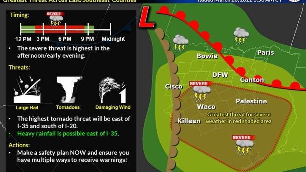
The storm has been upgraded to a Level 4 (moderate risk) south of DFW in the red areas (depicted below). The highest tornado threat will be south of Dallas and Fort Worth.
The forecasts currently predict large hail, isolated long-track tornadoes, and 70+ wind gusts this evening.
Weather aware: DFW, Tyler/ Longview, Waco, Temple, Austin, College Station, NW Houston, and points in between.
------------------
Timing of isolated tornado and large hail threat:
West of I-35 (Abilene to FTW): 3pm-7pm
DFW Metro (west to east): 6pm to 9pm
I-35 Corridor (DFW to New Braunfels): 5pm-8pm
75 Central Expressway (Sherman to Dallas): 6pm-9pm
Hwy 6 (Waco to B/CS): 6pm-11pm
I-45 (Dallas to NW HOU): 7pm(north)-11pm(south)
HWY 290 (Austin to NW HOU): 5pm-11pm
 National Weather Service
UPDATE: 8:00 a.m.
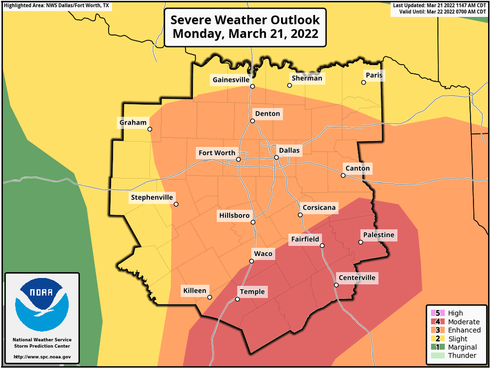
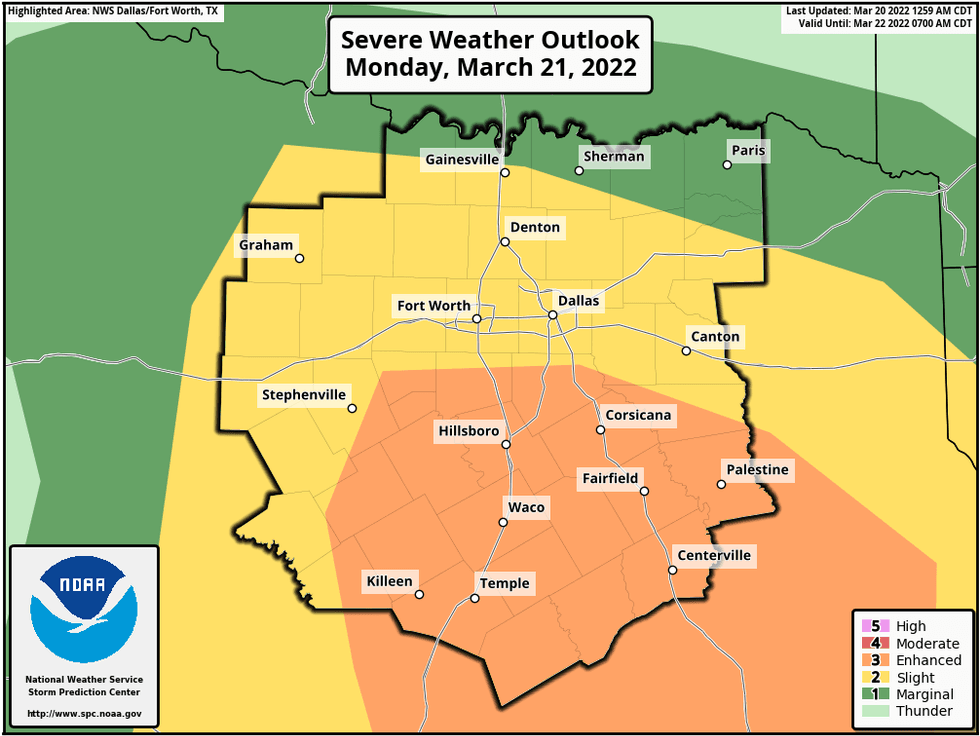
The Storm Prediction Center has now expanded the level 3 out of 5 risk for large hail, isolated tornadoes, and damaging wind northward towards the Red River (Hwy 82). All facets of severe weather are possible this afternoon through the evening.
Please stay weather aware between noon and 10 PM on Monday. All forms of severe weather are possible.
As we work our way through the late morning and early afternoon hours on Monday, numerous showers and strong thunderstorms will develop and stream from the south.
Severe threats between 10am and 3pm:
-Hail up to quarters
-Gusty wind
-Heavy rain
-Dangerous lightning
I'm not overly concerned about large hail or a tornado threat during this time-frame.
A Wind Advisory will also go into effect today at noon and last through 7 PM. Non thunderstorm wind gusts will approach 45 mph.
After this 1st wave of rain moves north of us by mid afternoon, we'll get a couple hour break from the storms. But, please do not let your guard down. Stay weather aware between 5pm and 9pm as well, as the dry line surges through the area.
Severe threats between 5pm and 9pm:
-Hail, quarters or larger (30% chance).
-isolated 'strong' tornadoes (5% chance).
-wind > 58mph (30% chance).
-Heavy rainfall
The Storm Prediction Center has put areas along and south of I-30 in a level 3 out of 5 for severe weather later this afternoon into the evening hours. A level 2 out of 5 is in place north of interstate 30, which includes the rest of north Texas.
 Sereve WeatherNational Weather Service
Lastly, I hope you haven't planted your gardens yet because we've got some chilly weather on the way. A strong cold front moves through tomorrow morning. Clouds will stick around all day, with a few showers possible. Temperatures will hold steady in the low fifties all day. Windchills in the forties!
Morning lows for Wednesday Thursday and Friday will dip into the upper thirties to low forties. Sunny and windy conditions will continue on Wednesday with a high near 60. Less wind with sunshine on Thursday low sixties, beautiful for Friday mid seventies. The weekend looks nice as well.
*Yest Rain: 0.00"; *Yest High: 82; Low: 51
*Today's Averages: High: 70; Low: 49
*Record high: 100 (1916); Record low: 27 (1913, 1965)
*February rain: 0.20"; March deficit: 1.84"
*2022 Rain: 2.41"; 2022 deficit: 5.02"
*Sunrise: 7:30 am; Sunset: 7:41pm
Today: *Wind Advisory noon-7pm* Cloudy, VERY windy and mild. Scattered late morning and early afternoon strong showers and storms (Threats: Heavy rain, small hail and wind). Mid afternoon break, then scattered severe storms from 5pm to 9pm (Threats: Large hail, isolated tornadoes and damaging wind). Rain totals 1 - 2". High: Near 70. Wind: SE 20-30, G45 mph.
Tonight: Rain moves out, cold front enters by daybreak. Staying cloudy. Low: Near 60. Wind: South 10-20 mph.
Tomorrow: Cloudy, windy and much colder. Slight chance for a shower. High: Steady in the low 50s. Wind: NW 15-25, G30 mph.
Wednesday and Thursday: Sunny, breezy and cool. Lows: Low 40s; High: Low 60s.
Friday: Sunny and warmer. High: Mid 70s.
Saturday: Morning DRY cold front. Sunny, breezy and slightly cooler. High: Mid to upper 60s.
Sunday: Sunny and perfect! High: Mid 70s.
LISTEN on the Audacy App
Sign Up and Follow NewsRadio 1080 KRLD