


A lot of you have seen some welcome rain over the past 12 hours, while others didn't see much at all. Unfortunately, DFW Airport only measured 0.29 in. Some areas receive two to three inches across parts of Denton and Dallas County.
We're waking up to temperatures in the upper 60s to low 70s with no rain showing up on radar in North Texas. They're a few leftover showers in East Texas and in southeast Oklahoma. Plenty of sunshine today, warm and humid with afternoon highs in the mid 90s. Heat index values will approach 100°.
We're back in the low 70s tonight under a mostly clear sky. More warmth will greet us tomorrow afternoon with afternoon highs back in the mid 90s.
 National Weather Service - Fort Worth
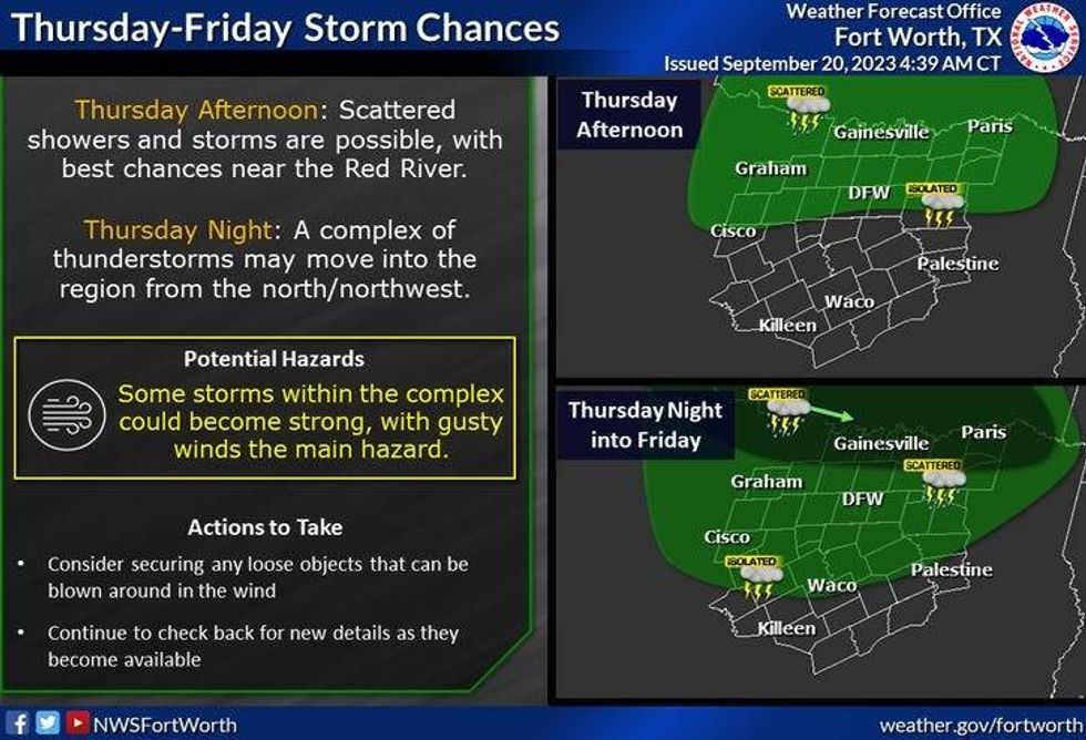
Our next rain chance arrives tomorrow evening into early Friday morning. The Storm Prediction Center has put areas along and north of Interstate 20 ain a level one out of five for isolated severe storms. This may be upgraded to a level two in some areas by tomorrow. Most of the rain will fall between 9:00 p.m. and 6:00 a.m. Thursday night into Friday.
A few leftover showers are possible Friday morning, then sunshine returns by late morning. Afternoon highs will warm into the low to mid 90s.
 National Weather Service - Fort Worth
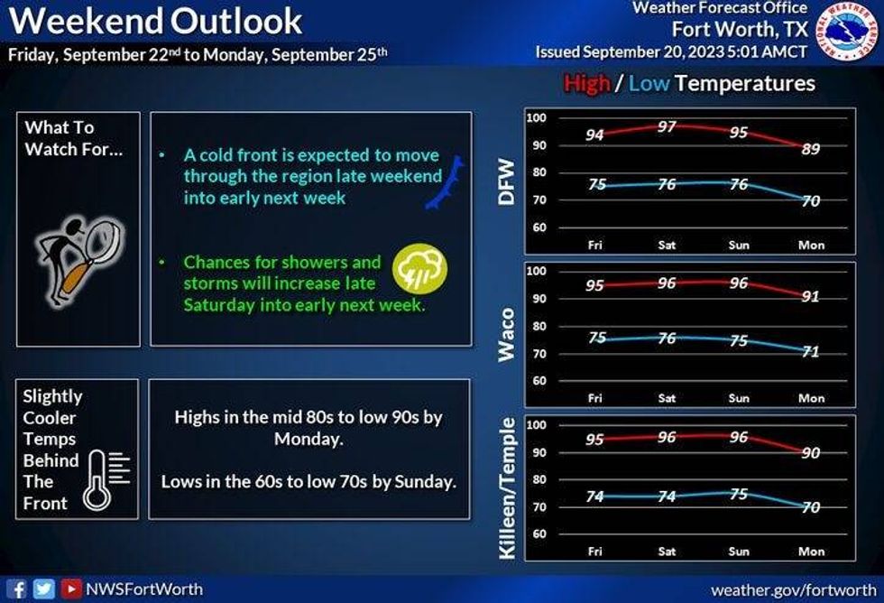
The mid 90s will continue into Saturday and Sunday with our next chance of rain arriving late Saturday and then again Sunday afternoon into the evening as a weak cold front sags through the area.
As of now I'm keeping Monday and Tuesday dry with seasonal temperatures. Afternoon highs will be in the upper 80s, with morning lows in the mid to upper 60s.
*Yest Rain: 0.00"; Yest High: 96; Low: 70
*Today's Averages: High: 87; Low: 67
*Record high: 102 (1953): Record low: 46 (1971)
*September Rain: 0.60"; Deficit: 1.23"
*2023 Rain: 15.43"; Deficit: 10.95"
*Sunrise: 7:15am; Sunset: 7:28pm
Today: Partly cloudy, warm and windy. High: Mid 90s. Wind: South 15-25 mph.
Tonight: Fair, breezy and mild. Low: 68-73. Wind: SSE 10-20 mph.
Thursday: Partly cloudy, warm and breezy. Scattered strong and isolated storms, mainly north of I-20 by evening. Threats: Hail and damaging wind. High: Mid 90s. Wind: South 10-20 mph.
Friday: Morning showers, mainly east of DFW, then afternoon sun. High: Low to mid 90s.
Saturday: *First day of Fall (1:50am)* Partly cloudy, windy and warm. Scattered late day showers and storms. High: Mid to upper 90s.
Sunday: Partly cloudy and warm. Scattered late day showers and storms. High: Mid 90s.
Monday and Tuesday: Mostly sunny and a tad cooler. High: Mid to upper 80s
LISTEN on the Audacy App
Tell your Smart Speaker to "PLAY 1080 KRLD"
Sign Up to receive our KRLD Insider Newsletter for more news
Follow us on Facebook | Twitter | Instagram | YouTube


