


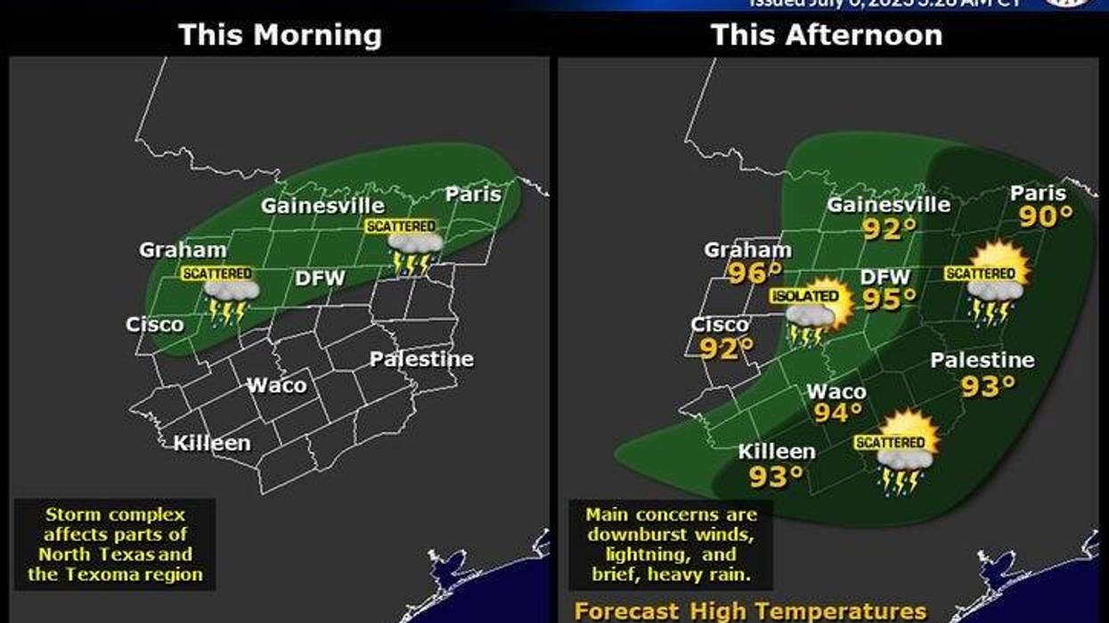
We begin Thursday with a dying area of showers to the west and NW of Fort Worth. An MCV (mesoscale convective vortex) formed overnight. This cold pool of air in the upper levels of the atmosphere may be the focal point for some new storm development by late morning and especially this afternoon anywhere across north Texas. I'm also watching a complex of storms in northwestern Oklahoma that are diving southeast and will slowly weaken as they approach the Red River Valley after lunchtime. Some of you may see some showers and storms today.
We also have a weak cool front that's stallied along the Red River Valley. This boundary may get pushed south of the Red River this afternoon, allowing more storms to form along it, especially East and northeast of DFW... I'll be monitoring throughout the day.
Great news: Due to the clouds around and a NE wind across the northern half of North Texas, temperatures will be a little cooler in these areas today near 90. Hotter south of I-20.
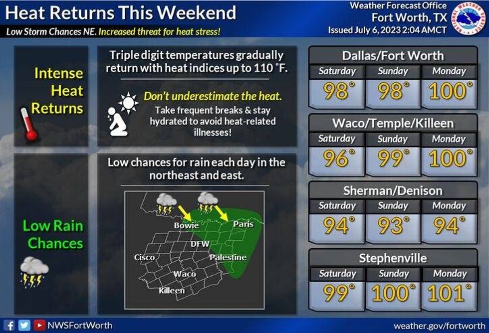
Tomorrow will be relatively dry with highs back in the upper nineties.
 National Weather Service - Fort Worth
By early Saturday morning and especially Sunday morning, another complex of storms will dive towards the Red River Valley. Some of these may make it into the northern half of north Texas, especially Sunday morning. Afternoon high through the weekend will reach the upper nineties.
One more chance of early morning storms on Monday before we dry out Tuesday through Thursday of next week. Afternoon highs will be at or slightly above 100 degrees, with possible heated advisories. returning to the area. Heat index values will be above 105 degrees, as our summertime weather pattern returns to north Texas.
*Yest Rain: 0.00"; Yest High: 98: Low: 80
*Today's Averages: High: 94 Low: 75
*Record high: 105 (1980, 1996): Record low: 59 (1972)
*July Rain: 0.00"; Deficit: 0.51"
*2023 Rain: 14.36"; Deficit: 6.44"
*Sunrise: 6:26am; Sunset: 8:40pm
Today: Partly cloudy and hot. Scattered afternoon and evening storms (best chance north and NW of DFW). A tad cooler. High: Low to mid 90s. Wind: SE 5-15 mph.
Tonight: Mostly cloudy and muggy. A few evening storms east of Dallas. Low: 75-80. Wind: South 10-15 mph.
Tomorrow: Partly cloudy and hot. High: Mid to upper 90s. Heat index: Near 104. Wind: South 10-20 mph.
Weekend: Partly cloudy and hot. Slight chance of early Sunday morning storms. High: Near 100. Heat index 105+.
Monday: Partly cloudy and hot. Slight chance of storms after midnight. Highs: 99-103. Heat index 105+.
Tuesday and Wednesday: Mostly cloudy and hot. Highs: 100-102.

LISTEN on the Audacy App
Tell your Smart Speaker to "PLAY 1080 KRLD"
Sign Up to receive our KRLD Insider Newsletter for more news


