It's Monday morning and I'm back to work. While it may not be exciting for everyone, the weather this week will be semi-exciting with a slight rain chance late Tuesday, but better rain chances arrive Friday into the first half of Saturday. Temperatures will also be well above average.
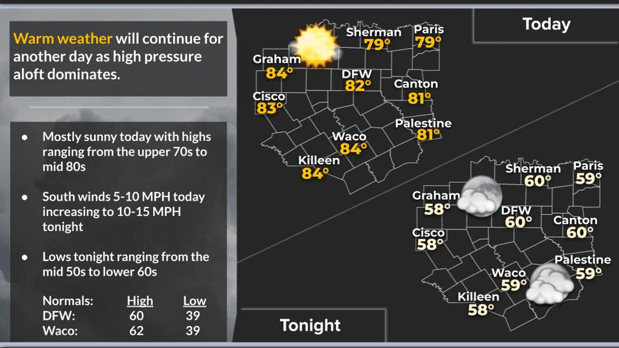
Good morning, and I hope you had a great weekend and enjoyed the Super Bowl. Congratulations to the Seattle Seahawks. We're waking up this morning with very mild temperatures, ranging from the upper 40s to near 60 degrees under a partly cloudy sky. No rain is on the radar, and none is expected until late Tuesday, but a lot of you won't see a drop. Temperatures today will get up close to 80 degrees again. This will be the 12th time so far this winter we've hit 80 degrees or higher.
After lows in the low 60s tomorrow morning, clouds will increase rapidly through the day tomorrow with afternoon highs in the mid to upper 70s. There is a slight chance of rain late Tuesday night, which should be out of here by early Wednesday morning for those of you who actually see some rain in your backyard.
Slightly dry air will work its way into North Texas on Wednesday, allowing temperatures to be a little bit cooler, with readings topping out in the mid to upper 60s. Thursday looks equally as nice but much warmer, with highs in the upper 70s to near 80 degrees.
Our next system coming in from the West will be a lot stronger than the one late Tuesday. Clouds will rapidly increase through the day, and afternoon highs will reach the mid 70s. Rain chances will start to creep in by Friday evening and pick up overnight into the first half of Saturday before moving out by afternoon. As of now, I'm not looking for anything too severe around here; however, residents in East Texas may see some severe storms with hail and wind being the primary threats. Temperatures will hover in the mid-60s all day. The sun will return on Sunday, with highs back in the mid-60s as dry air settles into the area.
That's a look at your weather on this fine Monday morning. Have an awesome day today, and please enjoy the weather when you can, it's the only weather you've got!
7-Day Headlines:
* DFW Airport reached 80 yesterday. 11th 80 degree temp this winter.
* Above average temperatures all week.
* Showers late Tuesday into early Wednesday.
* Higher rain chances Friday and Saturday.
* No cold air anytime soon.
* Second half of the weekend will be salvaged.
*Yest Rain: 0.00"; Yest High: 80; Low: 52
*Today's Averages: High: 60; Low: 39
*Record high: 87 (1960); Record low 11 (1960)
*February rain: 0.00"; Deficit:
*2026 Rain: 0.93"; Snow: 2.4" Deficit:
*Sunrise: 7:16am; Sunset: 6:09pm
Monday: Partly cloudy and mild. High: Near 80. Wind: SE 5-10 mph.
Monday night: Low clouds invade. Mild and muggy. Low: 55-60. Wind: South 5-10 mph.
Tuesday: Cloudy, breezy and mild. Chance of showers late. High: Upper 70s. Wind: South 10-20 mph.
Wednesday: Morning showers, then decreasing clouds and slightly cooler. High: Near 70.
Thursday: Partly cloudy and warmer. High: Upper 70s.
Friday: Increasing clouds and mild. Rain by evening. High: Mid 70s.
Saturday: Cloudy and rainy. A few strong storms by afternoon. High: Mid 60s.
Sunday: Sunny and beautiful. High: Upper 60s.
LISTEN on the Audacy App
Tell your Smart Speaker to "PLAY 1080 KRLD"
Sign Up to receive our KRLD Insider Newsletter for more news
Follow us on Facebook | Twitter | Instagram | YouTube