


We're starting Thursday with temperatures in the mid to upper 50s. This is where we should be during the afternoon hours this time of the year. There are also a few isolated showers on the radar, but will not amount to too much.
Clouds will stick around through the day today as a larger area of rain works its way in from the west late this afternoon through the evening. Afternoon highs will top out in the low to mid-60s. I'm forecasting about a quarter of an inch of rain by early tomorrow morning.
Morning drizzle will give way to some sunshine Friday afternoon with highs in the upper 60s. The air will remain very humid.
 National Weather Service - Fort Worth
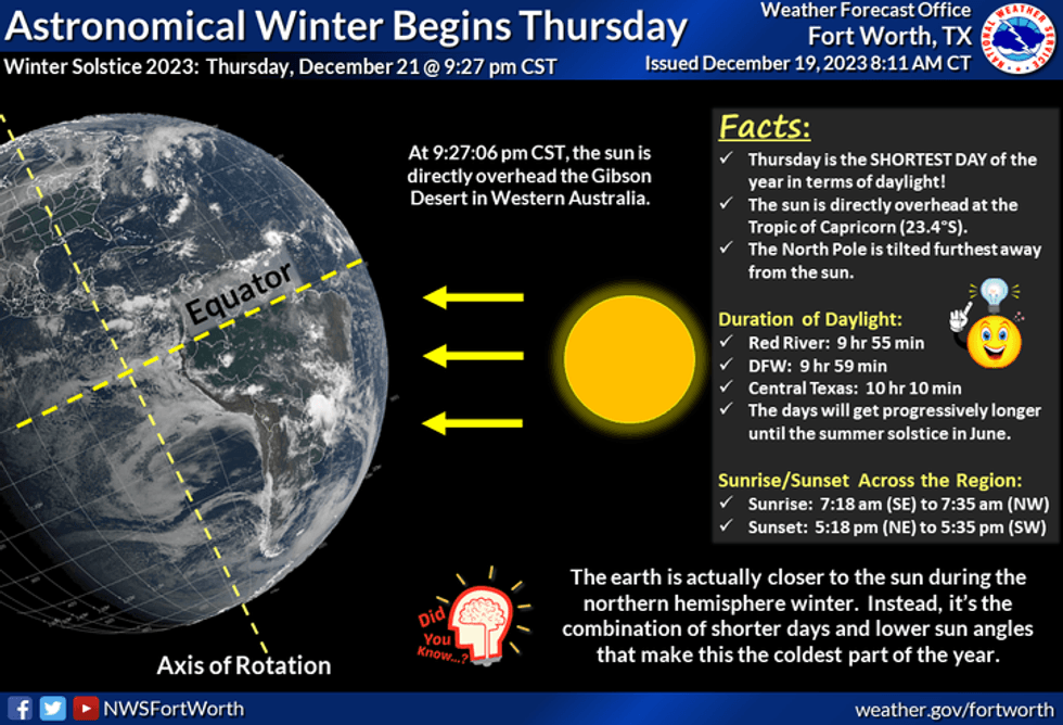
Winter arrives at 9:27 p.m. this evening, but unfortunately, it won't feel like it. Morning lows tomorrow will drop into the mid to upper 50s. There will be some patchy drizzle and a few showers lurking tomorrow morning for your commute to work. Some sunshine will return tomorrow afternoon with highs in the upper 60s. Rain chances are very slim.
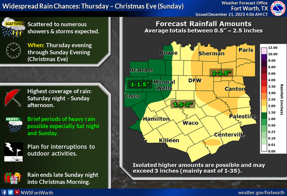
Clouds will roll back on Saturday morning. There will also be a few showers on the radar, but it won't amount to too much. Most of Saturday is rain-free until we get into the evening hours, as a large area of showers and storms will be forming to our west. These storms will plow through here while you're sleeping into Sunday morning. Some storms may contain some gusty wind and very small hail, but I'm not overly concerned as of now. The rain will quickly shift to the east by early afternoon. Afternoon sunshine will return with highs approaching 70°.
 National Weather Service - Fort Worth
Clouds will roll back in on Monday morning along a strong cold front. This front will plow through the area before you wake up and open Santa;s gifts! Windy and colder air will filter in as the sun returns by late morning into the afternoon. Afternoon highs will struggle to get above 50°.
Tuesday and Wednesday morning will have lows in the 30s with afternoon highs in the mid to upper 50s.
*Yest Rain: 0.00"; Yest High: 67; Low: 44
*Today's Averages: High: 57; Low: 37
*Record high: 85 (2010); Record low: 10 (1983)
*December rain: 0.60"; Deficit: 1.22"
*2023 Rain: 26.36"; Deficit: 9.63"
*Sunrise: 7:27am; Sunset: 5:26pm
Today: Cloudy, breezy and mild. Morning showers, then late day showers. (0.25"). "Winter arrives at 9:27 pm". High: Low to mid 60s. Wind: SSE 10-20 mph.
Tonight: Cloudy, mild and muggy. A few showers and pockets of drizzle. Low: Mid to upper 50s. Wind: South 10-15 mph.
Tomorrow: Morning showers, then partial clearing by afternoon. Mild. High: Upper 60s. Wind: South 10-15 mph.
Saturday: Isolated morning showers, then increasing showers and storms towards late evening. Some strong storms are possible overnight. (1.00" -1.50") High: Mid to upper 60s.
Christmas Eve Day: Morning showers and storms (0.25"), then partial afternoon clearing. High: Near 70.
Christmas Day: Morning cold front and clouds, afternoon sun. Windy and colder. High: Low 50s.
Tuesday: Partly cloudy and cool. High: Mid 50s.
Wednesday: Sunny and cool. High: Low 60s.
LISTEN on the Audacy App
Tell your Smart Speaker to "PLAY 1080 KRLD"
Sign Up to receive our KRLD Insider Newsletter for more news
Follow us on Facebook | Twitter | Instagram | YouTube


