


**COOL MORNINGS & MILD TO PLEASANT AFTERNOONS!**
Our weather story here through the weekend features cooler mornings and afternoons. Plus, some of you will actually see some much-needed rain late Saturday and into Sunday! How do you like them apples?
Good morning, everyone! Welcome to almost Friday!
**CHILLIER START TO YOUR THURSDAY**
Temperatures this morning are noticeably cooler than the past couple of mornings thanks to that weak cold front that moved through late yesterday afternoon. Readings have dropped into the upper 40s to low 50s, so you'll definitely want a jacket heading out the door.
The good news? No significant wind chill to worry about!
**BEAUTIFUL WEATHER TODAY & FRIDAY**
It's going to be a gorgeous day across North Texas, with light winds and afternoon highs reaching the low 70s. Similar weather is expected tomorrow, with highs near 70 degrees and morning lows again in the upper 40s to low 50s.
Unfortunately, no rain in the forecast for the next couple of days, and we desperately need it!
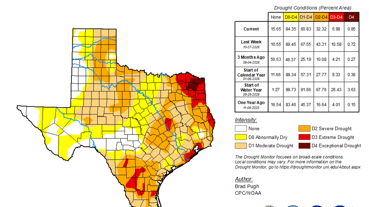
**OUR DROUGHT SITUATION CONTINUES TO WORSEN**
The rainfall deficit at DFW Airport is now approaching 6 inches for the year. Some of you are doing a little better in your own backyards, while others are actually running further behind.
But there is some hope on the horizon!
**RAIN CHANCES RETURN LATE SATURDAY INTO SUNDAY**
An upper-level disturbance will move in from the Northwest late Saturday night and track generally along the Red River.
Here's the timing:
**Saturday:** Clouds will gradually increase throughout the day. Rain will begin developing off to our Northwest by Saturday evening. You shouldn't cancel your dinner plans around the Dallas-Fort Worth area, but showers will be approaching places like Breckenridge and Wichita Falls shortly after dinner.
**Sunday:** This fast-moving system will spread light to moderate rain, possibly accompanied by an isolated thunderstorm, from Northwest to Southeast across North Texas.
Unfortunately, rainfall totals won't be especially impressive for most of us. We're generally looking at around a half-inch or less, although isolated totals approaching an inch are possible along the Red River, east of Sherman, through Paris, Texarkana and Northeast Texas.
**OUR COLDEST AIR OF THE FALL SEASON IS COMING!**
This system will also usher in some of the coldest air we've experienced this fall.
We're not talking about morning freezes just yet. Our average first freeze date is November 22, but we're getting closer!
Morning lows will drop into the 40s Monday, Tuesday and Wednesday.
Afternoon temperatures:- Sunday: Upper 50s- Monday: Upper 50s- Tuesday: Low 60s- Wednesday: Mid 60s
So, a little bit of much-needed rain followed by some beautiful fall weather and cooler temperatures!
Have a fantastic Thursday, everyone! I'm taking tomorrow off, so you won't hear much from me, but I'll be back this weekend to update you on the timing of Sunday's rain and the latest projected precipitation totals.
In the meantime, enjoy your day, and please **LIKE and SHARE** to help keep North Texas weather aware!
Talk to you soon!
7-Day Headlines:
- DFW Airport hit 80 degrees on Wednesday.
- Cooler weather is on the way
- Friday morning weak cold front, no rain
- Rain moves in late Saturday into Sunday, chilly Sunday
- Totals under 0.50”; nothing severe
- MUCH cooler early next week
- Download our AUDACY app! Listen to KRLD LIVE at home or at work
Almanac:
- Yest Rain: 0.00”; Yest High: 80; Low: 56
- Today’s Averages: High: 68; Low: 47
- Record high: 85 (1951, 1955); Record low 21 (1911)
- November rain: 0.04”; Deficit: <1.07”>
- 2026 Rain: 26.81”; Snow: 2.4”; Deficit: <5.94”>
- Sunrise: 6:57am; Sunset: 5:28pm
Forecast:
Thursday: Sunny and a tad cooler. High: Mid 70s. Wind: North 5-10 mph.
Thursday night: Clear and cool. Low: Mid to upper 40s. Wind: NE 5-10 mph.
Friday: Sunny and a tad cooler. High: Upper 60s. Wind: NE 5-10 mph. High: Low 60s.
Saturday: Increasing clouds and cool. Showers northwest of DFW by evening. High: Mid 60s.
Sunday: Cloudy and cool. A decent shot of rain. High: Mid to upper 50s.
Monday: Morning clouds and drizzle, peeks of afternoon sun. Cool! Mid to upper 50s.
Tuesday: Partly cloudy, continued cool. High: Low 60s.
Wednesday: Partly cloudy and perfect! High: Mid to upper 60s.
LISTEN on the Audacy App
Tell your Smart Speaker to "PLAY 1080 KRLD"
Sign Up to receive our KRLD Insider Newsletter for more news