Keep your umbrella handy, as it will be needed later Thursday through mid-afternoon Friday. The rain will give way to a sunny weekend.
Showers on Thursday are expected to begin after noon. Temperatures will be in the low 70s.
A strong storm system moved through northeast Mexico on Thursday morning and will cruise along the I-10 corridor over the next 36 hours. Some areas of South Texas have already received over 6 inches of rain, with more expected. This system will bring rain to North Texas later Thursday and intermittently through Friday afternoon. It appears the heaviest rain will remain south and east of the Dallas-Fort Worth area, with severity expected to be very low.
Temperatures Thursday morning were near 60 degrees. There will be partial sunshine, with afternoon highs reaching the mid-70s. The first wave of rain will arrive in the afternoon and evening, followed by a more widespread wave before the morning commute on Friday, continuing intermittently through the afternoon. Precipitation totals will be less than an inch area-wide.
Overnight lows will drop to the low 60s, with highs only in the upper 60s tomorrow and no sunshine. The rain will clear by Friday evening, but clouds will persist.
The weekend starts in the low 60s and reaches the mid-80s by Saturday afternoon as sunshine returns. It will be breezy as well. On Sunday, expect morning clouds and afternoon sun, with highs near 80 degrees. A cold front will move into the area during the day, potentially producing strong to severe storms across parts of North Texas. The threat appears to be south and east of DFW, but the dry line will be monitored as it moves in our direction by late afternoon. A strong cap will be in place.
Drier air will move in behind the front early next week, along with cooler temperatures. Expect plenty of sunshine on Monday, with highs in the upper 60s, followed by sunny skies and mid-to-upper 70s on Tuesday. We will return to the 80s by Wednesday, with the potential for more storms. This event will be monitored as we get closer.
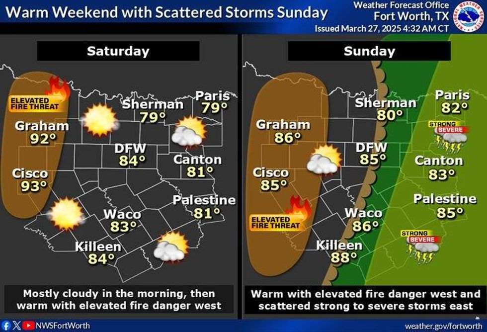 North Texas forecast for Saturday and Sunday, March 27-28, 2025.National Weather Service
7-Day Headlines
DFW reached 80 degrees on Wednesday.
Thursday is mostly rain-free.
Scattered showers and isolated storms Thursday night and Friday.
Most see less than an inch. Nothing severe.
A nice, but warm weekend ahead. 80s return!
A few storms late Sunday afternoon, mainly south of I-20.
Cooler early next week.
*Wednesday Rain: 0.00"; Wednesday High: 80 Low: 63
*Thursday's Averages: High: 72; Low: 51
*Record high: 96 (1956): Record low: 23 (1955)
_________________________________________________________
*March Rain: 1.28"; Deficit:
*2025 Rain: 8.32"; Surplus: 0.24"
*Sunrise: 7:21am; Sunset: 7:46pm
_________________________________________________________
Thursday: Cloudy and mild. A few showers. High: Mid to upper 70s. Wind: SE 15-25 mph.
Thursday night: Cloudy and mild. Scattered showers and isolated non-severe storms. Low: Low 60s. Wind: South 15-25 mph.
Friday: Cloudy, breezy and mild. Scattered showers and isolated storms. High: Upper 60s. Wind: SE 15-25 mph.
Saturday: Morning clouds, afternoon sun. VERY warm. High: Mid to upper 80s.
Sunday: Morning clouds, afternoon sun. A late-day cold front brings a few strong storms, mainly south of I-20. High: Near 80.
Monday: Sunny and cooler. High: Upper 60s.
Tuesday: Mostly sunny and beautiful. High: Mid to upper 70s.
Wednesday: Partly cloudy, much warmer. High: Upper 80s.
LISTEN on the Audacy App
Tell your Smart Speaker to "PLAY 1080 KRLD"
Sign Up to receive our KRLD Insider Newsletter for more news
Follow us on Facebook | Twitter | Instagram | YouTube