A significant storm system impacted the region last night and into early this morning, followed by a wind advisory and a notable cold front this afternoon. This system will cool things off significantly tonight through Thursday.
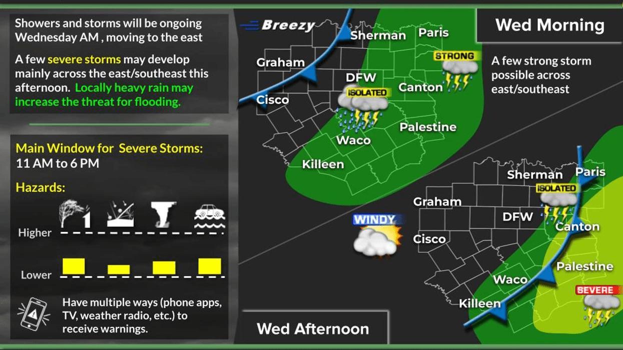
Good morning and welcome to Wednesday. Currently, scattered showers and isolated thunderstorms are moving into the area from the southwest. This precipitation will gradually shift eastward by mid to late morning. All warnings have been canceled. Rainfall totals over the past 12 hours range from 1 to 3 inches across North Texas. DFW Airport has received just over an inch of rain, while other areas within the Dallas-Fort Worth region have seen varying amounts.
As the cold front approaches the area around noon, skies will clear gradually from northwest to southeast throughout the afternoon. A wind advisory will take effect at 1:00 p.m. today, remaining in place through mid-evening, with wind gusts reaching up to 45 mph.
Cooler, drier air will follow the front, causing temperatures to drop into the 40s by tomorrow morning, with wind chills in the 30s. Afternoon highs will reach the mid-60s, making for a beautiful day.
Temperatures will fall into the 40s again by Friday morning under clear skies. Expect sunny conditions with highs returning to the 70s and low humidity. South winds will gradually return.
The weekend is forecast to be mostly fantastic, with plenty of sunshine on Saturday and lows in the 50s, warming rapidly to near 80°F. On Sunday, temperatures will fall to near 60° by morning, with afternoon highs approaching 80° by early afternoon.
A strong cold front will then move through the area, although it will not bring any precipitation. Temperatures will plummet into the 30s to low 40s by Monday morning, accompanied by a stiff north wind creating wind chill values in the 20s in some areas. Despite plenty of sunshine, temperatures will remain cool, with afternoon highs only reaching the low to mid-50s.
Freezing temperatures are expected in some areas on Tuesday morning, particularly northeast of the Dallas-Fort Worth area. Plenty of sunshine and slightly warmer temperatures are forecast, with highs returning to the 60s. A warming trend will continue through the middle to end of next week, with no precipitation expected.
Have a great day today and enjoy the weather when you can, it's the only weather you've got.
7-Day Headlines:
* DFW Airport reached 82 yesterday.
* Rain moving out, afternoon cold front moves in.
* Wind Advisory today from 1pm to 10pm. Gusts over 40mph.
* Colder air moves in. Some 30s Thursday morning.
* A seasonable day on Thursday. 60s!!
* A rapid warm up Friday through Sunday.
* STRONG/dry cold front Sunday afternoon.
* Light freezes in areas Monday and Tuesday morning.
*Yest Rain: 0.71"; Yest High: 82; Low: 62
*Today's Averages: High: 67; Low: 47
*Record high: 93 (1955); Record low 11 (1948)
*March rain: 2.41"; Surplus: 1.30"
*2026 Rain: 3.65"; Snow: 2.4" Deficit:
*Sunrise: 7:42am; Sunset: 7:34pm
Wednesday: Morning showers, afternoon clearing behind a windy cold front. **Wind Advisory 1pm-10pm** High: Mid to upper 70s. Wind: South to north 20-30, G45 mph.
Wednesday night: Clear, windy and colder. Low: 35-42. Wind North 15-25 mph.
Thursday: Sunny and cool. Less wind by afternoon. High: Mid 60s. Wind Lt. Var.
Friday: Sunny, warmer, continued nice. High: Near 80.
Saturday: Sunny, windy and beautiful. High: Low 80s.
Sunday: Partly cloudy, turning windy and colder by afternoon. High: Low to mid 80s.
Monday: Sunny, windy and chilly. Low: Low to mid 30s; High: Low 50s.
Tuesday: Sunny, less wind and pleasant. Low: 30-40; High: Low 60s.
LISTEN on the Audacy App
Tell your Smart Speaker to "PLAY 1080 KRLD"
Sign Up to receive our KRLD Insider Newsletter for more news
Follow us on Facebook | Twitter | Instagram | YouTube