


Winter Storm Warnings and Winter Weather Advisories issued this week for North Texas were allowed to expire after a series of rain, sleet, and snow moved across the area.
Snowfall totals in parts of North Texas exceeded half a foot. The town of Knollwood in Grayson County recorded 11 inches, Muenster recorded 8 inches of snow, and Montague County recorded 7 1/2 inches.
Plenty of sunshine is expected throughout the weekend, with highs in the low to mid-40s, which will alleviate the sleet and snow.
 Saturday morning temperaturesNational Weather Service
Black ice is present Saturday morning, with temperatures expected to thaw by noon, remaining cold through next Wednesday, and then rising to the 60s next Thursday and Friday.
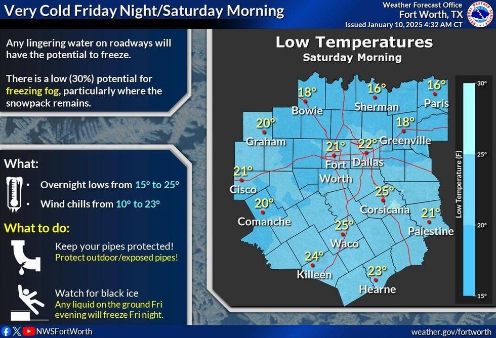
Temperatures Saturday morning began in the upper teens to mid-twenties across North Texas. The coldest temperatures were in areas with measurable snow still on the ground, mainly along and north of Interstate 30 and Interstate 20 west of Fort Worth. By late morning, temperatures will be safely above freezing, with sunshine and improved road conditions across northern North Texas.
Saturday will be sunny, with highs between 45° and 50° and south winds at 10 to 20 mph.
Tonight, temperatures will fall to slightly below freezing in snowpack areas and the low to mid-30s along and south of DFW under clear skies.
Another cold front will pass through Sunday morning, shifting winds to the north at 10 to 20 mph, with ample sunshine and afternoon highs in the mid-40s. A freeze is expected Monday morning, with temperatures falling to the mid to upper twenties.
Monday afternoon will be sunny, with highs in the mid-40s, over 10° below average for this time of year. Another freeze is expected Tuesday morning, with readings dropping to the low to mid-twenties.
It will remain chilly on Wednesday, but warmer, with afternoon highs reaching the low 50s. A warm-up will continue Thursday and Friday, with highs of 60° and 65°, respectively.
Looking ahead, Arctic air is expected to return next weekend, leading to a prolonged period of cold temperatures, with morning lows in the teens and afternoon highs struggling to reach freezing. While it is too early to discuss precipitation chances, the cold air will be monitored for potential developments.
7-Day Headlines:
* DFW Airport reached 38 yesterday. 0.03" of precip.
* Black ice and frozen slush through noon., north and NE of DFW.
* Below average temperatures for a while.
* No rain or snow expected.
* 60s by Thursday and Friday.
* Strong cold front this weekend. Dry for now.
_____________________________________________________
*Yest Rain: 0.03"; Yest High: 38; Low: 31
*Today's Averages: High: 56; Low: 36
*Record high: 85 (2023); Record low: 4 (1918)
__________________________________________________________
*January Rain: 1.56"; Surplus: 0.69"
*2025 Rain: 1.56"; Surplus: 1.56"
*Sunrise: 7:31am; Sunset: 5:42pm
__________________________________________________________
Today: Icy roads this morning, then mostly sunny and chilly. High: 45-50. South 10-20 mph.
Tonight: Clear and cold. Low: 28-34. Wind: South 10-20 mph.
Tomorrow: Morning "DRY" cold front. Sunny, breezy and chilly. High: Mid to upper 40s. Wind: North 10-20 mph.
Monday: Mostly sunny, continued cold. High: Low to mid 40s.
Tuesday: Mostly sunny and cool. High: Near 50.
Wednesday: Mostly sunny, continued cool. High: Low to mid 50s.
Thursday: Partly cloudy and warmer. High: Near 60.
Friday: Mostly sunny and perfect! High Mid 60s.
LISTEN on the Audacy App
Tell your Smart Speaker to "PLAY 1080 KRLD"
Sign Up to receive our KRLD Insider Newsletter for more news
Follow us on Facebook | Twitter | Instagram | YouTube


