A relatively straightforward forecast anticipates a rapid warming trend, featuring near record-breaking heat on Friday and Sunday, with no precipitation expected over the next seven days. Furthermore, spring will officially commence shortly before 11:00 a.m. on Friday.
Good morning, and welcome to Wednesday. As you head out, a light jacket will be necessary due to temperatures in the mid-to-upper 40s, accompanied by a south wind of 8 to 12 miles per hour. Clear skies are expected, making for a beautiful day with temperatures approximately 10 degrees warmer than yesterday, reaching afternoon highs in the mid-70s. Breezy south winds will gust up to 25 miles per hour.
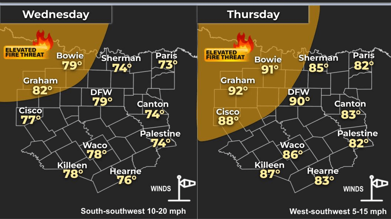
It is worth noting that there is a grass fire danger northwest of Dallas in Fort Worth today and Thursday. A rapid warm-up is expected on Thursday, with temperatures jumping into the mid-80s, nearing 90 degrees west of Decatur and Weatherford.
On Friday, temperatures will rise into the low to mid-90s, with the warmest temperatures again west of DFW. The record at DFW Airport is 92 degrees.
If you have plans in town or are heading to the Texas coast this weekend, the weather will be pleasant, albeit very warm for this time of year. Beach temperatures in the low to mid 80s.
Our weather will be VERY warm, with afternoon highs in the low 90s on Saturday and mid-to-upper 90s on Sunday. The record high on Sunday at DFW is 94 degrees, which will likely be broken, with possible triple-digit temperatures west of DFW.
By Sunday night, our next cold front will arrive, bringing temperatures back into the low 70s for highs on Monday, before rebounding nicely by Tuesday, reaching the low 80s.
Some extended model trends suggest a possible weather change towards the end of March and early April, which bears monitoring, although it is still two weeks away.
Have a terrific day today and enjoy the weather when you can, it's the only weather you've got.
LISTEN on the Audacy App
Tell your Smart Speaker to "PLAY 1080 KRLD"
Sign Up to receive our KRLD Insider Newsletter for more news
Follow us on Facebook | Twitter | Instagram | YouTube
7-Day Headlines:
* DFW Airport reached 64 yesterday.
* A chilly start this morning, a perfect day ahead!
* Warming up through the weekend.
* PERFECT weather for outdoor activities.
* No rain for a while.
* Spring arrives Friday at 10:46am
* Near record-breaking heat Friday and Sunday. 90's y'all!
*Yest Rain: 000"; Yest High: 64; Low: 35
*Today's Averages: High: 69; Low: 48
*Record high: 92 (1907); Record low 20 (1923)
*March rain: 2.91"; Surplus: 1.08"
*2026 Rain: 5.15"; Snow: 2.4" Deficit:
*Sunrise: 7:33am; Sunset: 7:39pm
Wednesday: **Grass fire danger NW of DFW** Sunny, breezy and perfect! High: Mid 70s. Wind: SSW 15-25 mph.
Wednesday night: Clear and cool. Low: Low 50s. Wind: South 10-15 mph.
Thursday: **Grass fire danger NW of DFW** Sunny and warm. High: Mid to upper 80s. Wind: SSW 10-20 mph.
Friday: FIRST DAY OF SPRING! Sunny and VERY warm. Near record (92 degrees) breaking heat. High: Low 90s.
Saturday: High clouds and VERY warm. High: Low to mid 90s.
Sunday: High clouds and HOT. Record (94 degrees) high temperatures. High: Mid to upper 90s! Late evening cold front.
Monday: Sunny, windy and cooler. High: Low 70s.
Tuesday: Sunny and warmer. South winds return. High: Low 80s.