After record-breaking rainfall across North Texas on Wednesday, Mother Nature responded with dense fog Thursday morning. For some, showers and strong storms return in the first half of Friday, before transitioning into a sunny and beautiful weekend.
Dense fog invaded areas south of the Dallas-Fort Worth area Wednesday morning, reducing visibility to less than a quarter of a mile, especially in rural areas. Temperatures were mild to start the day, with readings near 60 degrees. This afternoon will feature sunny conditions with a high of 84 degrees.
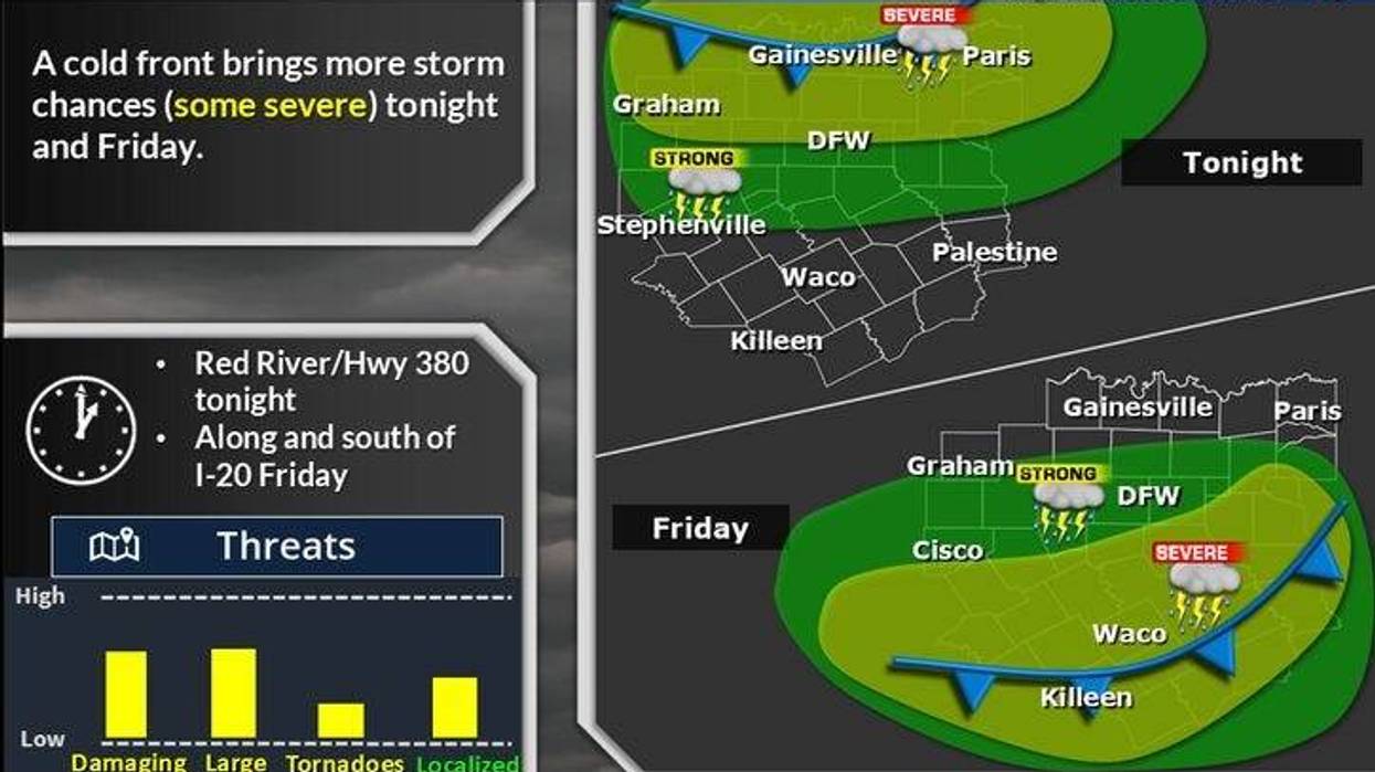
The next weather system will approach late Thursday in the form of a cold front, bringing numerous showers and storms from western Oklahoma. Most data suggests this complex will weaken as it moves through, then regenerate into widespread shower and thunderstorm activity south of the Dallas-Fort Worth area Friday afternoon and evening. Some of these storms may be discrete supercells containing large hail, damaging winds, and isolated tornadoes. While a significant severe weather threat is unlikely, gusty winds are possible as the complex approaches shortly after daybreak tomorrow. Morning lows will dip into the mid-to-upper 60s, with afternoon highs struggling to reach 80 degrees.
The weekend is expected to be pleasant, with plenty of sunshine and highs in the mid-70s on Saturday and upper 70s on Sunday. If attending Mayfest in Fort Worth this weekend, be prepared for wet conditions.
Monday will be another pleasant day, with highs nearing 80 degrees. The next weather change will arrive Tuesday into Wednesday of next week, bringing widespread showers and thunderstorm activity. While it is too early to determine if any storms will become severe, plan for a wet midweek ahead. Temperatures will be in the 70s, accompanied by rain.
7-Day Headlines
DFW hit 73 degrees on Wednesday. Rain: 2.40"
Dense Fog Advisory Thursday morning.
A decent day on Thursday.
Friday Storms, severe south of DFW.
An awesome weekend!
There will be more storms next Tuesday and Wednesday. Some severe.
*Wednesday Rain: 2.40"; Wednesday High: 73 Low: 59
*Thursday's Averages: High: 79; Low: 60
*Record high: 92 (1948, 2003): Record low: 34 (1903)
_________________________________________________________
*April Rain: 5.22"; Surplus: 2.00"
*2025 Rain: 13.93"; Surplus: 2.12"
*Sunrise: 6:39am; Sunset: 8:11pm
_________________________________________________________
Thursday: Morning Dense Fog Advisory, becoming partly cloudy and nice. High: Mid 80s. Wind: Lt. Var.
Thursday night: Increasing clouds and muggy. Watch out for the morning storms sneaking in from the north. Low: 48-55. SE 5-10 mph.
Friday: Morning strong storms, some afternoon sun. Cooler by evening. High: near 80. Wind: SE 5-10 mph.
Saturday: Mostly sunny and beautiful. High: Mid 70s.
Sunday: Partly cloudy and pleasant. High: Upper 70s.
Monday: Partly cloudy, continued nice. High: near 80.
Tuesday and Wednesday: Mostly cloudy. Scattered showers and strong storms. Highs: 70s.
LISTEN on the Audacy App
Tell your Smart Speaker to "PLAY 1080 KRLD"
Follow us on Facebook | Twitter | Instagram | YouTube