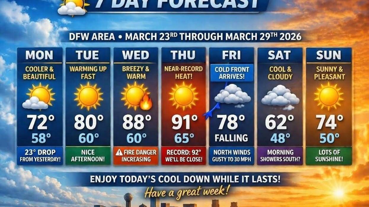
After record-breaking heat yesterday, Mother Nature has provided a brief respite with cooler temperatures expected today and tomorrow. A notable 23-degree drop in temperature is anticipated today compared to yesterday. However, this cooler spell will be short-lived, as a significant warm-up is forecasted through Thursday.
Good morning, and I hope you had a chance to endure the heat over the weekend. Ha! A cold front moved through overnight, bringing temperatures down slightly this morning. Current readings range from the upper 50s to low 60s. Today is expected to be a beautiful day with increasing cloud cover by late afternoon. Afternoon highs will only reach the low 70s, which is a welcome relief from yesterday's 95 degrees. Unfortunately, the cooler weather will not last long.
The front will lift back to the north tonight, and temperatures will fall into the upper 50s to low 60s for your Tuesday morning commute. Temperatures will rebound nicely, reaching near 80 degrees by Tuesday afternoon in Wilmington.
Grass fire danger will increase on Wednesday and Thursday, with southwinds gusting up to 30 mph. Temperatures will also warm up, with afternoon highs reaching the middle 80s on Wednesday and low 90s on Thursday. Notably, the record high for Thursday is 92 degrees, and we will come close to tying that record.
Our next weather change will arrive on Friday morning, as the upper level ridge of high pressurebuild back into the desert southwest, allowing a northwesterly flow to set up. This will enable a strong cold front to pass through the area around noon on Friday. Some areas, especially south of DFW, will reach the low 80s, while most areas will reach the upper 70s before cooling into the 50s by dinner time on Friday evening. North winds will gust up to 30 mph throughout the day, allowing cooler, drier air to filter in from the central plains states.
If you're lucky, you might see a few showers late Friday night into Saturday morning, but most areas will remain dry. Saturday's forecast is uncertain. A few morning showers will move out of the area, and if the clouds don't clear, temperatures will struggle to rise above the low 60s. Any sunshine will warm temperatures up into the upper 60s during the day.
Temperatures on Sunday morning will fall into the upper 40s to low 50s. Plenty of sunshine is expected on Sunday afternoon, with highs in the low to mid-70s.
Have a great day today, and enjoy the weather when you can, it's the only weather you've got!
7-Day Headlines:
* DFW Airport reached 95 yesterday. Broken record!
* 20+ degrees cooler today.
* Warming temperatures Tuesday - Thursday.
* WInd picks up, grass fire danger.
* Friday morning windy cold front. A few showers.
* A cool weekend.
* Warming back up next week.
*Yest Rain: 000"; Yest High: 95; Low: 54
*Today's Averages: High: 71; Low: 50
*Record high: 91 (2029); Record low 28 (1952)
*March rain: 2.91"; Surplus: 0.55"
*2026 Rain: 5.15"; Snow: 2.4" Deficit:
*Sunrise: 7:26am; Sunset: 7:43pm
Monday: Partly cloudy, breezy and cooler. High: Low 70s. Wind: North 10-20 mph.
Monday night: Partly cloudy and pleasant. Low: Mid to upper 50s. Wind: East 5-10 mph.
Tuesday: Partly cloudy and warmer. High: Mid to upper 80s. Wind: SE 5-15 mph.
Wednesday: Sunny, breezy and warm. Grass fire danger. High: Mid to upper 80s.
Thursday: Mostly sunny, windy and warm. High: Low 90s. The record is 92 degrees.
Friday: Increasing clouds. Morning cold front. Windy and cooler, with a few showers late. High: Near 80 early, falling into the 50s by early evening.
Saturday: Mostly to partly cloudy, breezy and cool. High: Low to mid 60s.
Sunday: Sunny and perfect! High: Mid 70s.
LISTEN on the Audacy App
Tell your Smart Speaker to "PLAY 1080 KRLD"
Sign Up to receive our KRLD Insider Newsletter for more news
Follow us on Facebook | Twitter | Instagram | YouTube