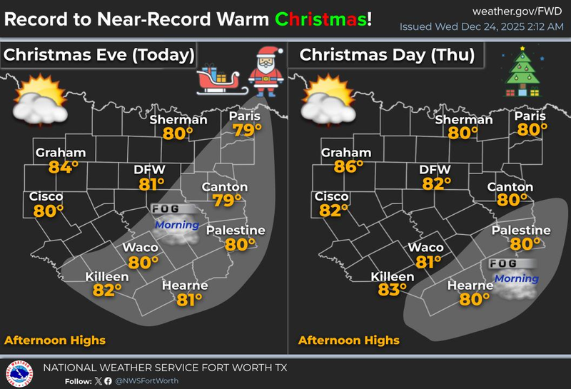
"What in the wide-wide-world of sports is going on around here?" The weather in North Texas during the holiday season has been quite unusual. Temperatures are expected to remain above average, while precipitation will be below average until late Sunday afternoon.
Good morning, Santa, and to all my Facebook friends and followers. With the day before Christmas upon us, the weather feels more akin to the day before Mother's Day. Temperatures have only dipped into the low and mid-60s under an increasingly cloudy sky. Yesterday, a record was set at DFW Airport with a high of 82 degrees. Today's record stands at 88 degrees, which we will not surpass. However, it will still be quite warm with highs nearing 80 degrees. At this rate, we may need to mow our lawns again soon.
The unseasonably warm weather pattern will persist on Christmas Day, with afternoon highs nearing 80 degrees once more. Although we will not break any records on Christmas Day, we may do so on Friday and Saturday as temperatures soar into the low and mid-80s. Morning clouds will also be present, but they will not bring any precipitation.
We will finally experience a dip in the jet stream on Sunday, allowing a strong cold front to move through the area by Sunday evening. Some of you may be fortunate enough to experience a brief bout of light to moderate rain, but coverage will be limited to around 30%. Following highs in the mid-to-upper 70s on Sunday, you can expect a north wind of 15 to 25 miles per hour and temperatures in the mid-to-upper 30s by Monday morning. Wind chills will be near freezing, which will be a shock to the system. Please remember to bring your pets indoors before bedtime on Sunday evening. There will be no need to drip your faucets.
Monday will be mostly cloudy and chilly, with pockets of drizzle possible, especially during the morning hours, as temperatures struggle to rise above 45 degrees. Fortunately, better weather is expected on Tuesday, with ample sunshine and highs returning to the low to mid-50s. A continued warm-up is anticipated thereafter.
I will be taking Christmas Day and Friday off. Although I may provide updates on the weather if necessary, there are no significant changes expected until late Sunday.
I wish everyone a blessed Christmas, and I hope you receive everything you desire under the tree. Don't forget to enjoy the weather when you can, it's the only weather you've got!
7-Day Headlines:
* DFW Airport reached 82R yesterday.
* Some morning clouds, afternoon sun through Saturday.
* Above average temperatures/below average temperatures through Saturday.
* Mountain Cedar pollen high all week.
* Flirting with record highs Friday and Saturday.
* No weather travel delays across the 5-state area.
* Next cold front on Sunday. Slight rain chance. Colder.
*Yest Rain: 0.00”; Yest High: 82R; Low: 55
*Today’s Averages: High: 56; Low: 37
*Record high: 88 (1955); Record low: 7 (1983)
*December Rain: 0.08"; Deficit:
*2025 Rain: 38.31"; Surplus: +2.04”
*Sunrise: 7:29am; Sunset: 5:28pm
Wednesday: Morning clouds, afternoon sun. Breezy and warm. High: Near 80. Wind: South 10-20 mph.
Christmas Eve: Partly cloudy and mild. Low: Low to mid 60s. Wind: South 10-15 mph.
Christmas Day: Morning clouds, afternoon sun. Breezy and very warm. High: Low 80s. Wind: South 10-20 mph.
Friday and Saturday: Morning clouds, afternoon sun. Breezy, with near record heat! Highs: Low to mid 80s.
Sunday: Increasing clouds, turning windy and colder by evening. A slight chance of showers along the cold front. High: Mid 70s.
Monday: Cloudy, breezy and chilly. Drizzle possible. High: Mid to upper 40s.
Tuesday: Mostly sunny and cool. High: Low to mid 50s.
LISTEN on the Audacy App
Tell your Smart Speaker to "PLAY 1080 KRLD"
Sign Up to receive our KRLD Insider Newsletter for more news
Follow us on Facebook | Twitter | Instagram | YouTube
