


We're inching closer to fall and we have some nice weather changes coming over the next 7 days that include rain and cooler temperatures.
We're eight days away from opening day of the State Fair of Texas, and 2 days away from the official first day of fall.
We're starting off in the 70s this morning with nothing showing up on radar at this time. However, this will change as we work our way into late this afternoon, through the evening and into the overnight hours.
An active subtropical jet stream and a cold front will give us several chances of showers and storms through early Monday morning. The first chance of storms, some of them may be severe, will arrive late this afternoon through the early evening... mainly along and north of Highway 380. Quarter size hail and damaging wind will be the threats. Afternoon highs today will reach the low to mid 90s again.
After the first wave of storms moves east of DFW, another wave will move through the area into the early morning hours. Most of these will be subsevere, but a bunch of noise and some welcome rain will fall especially along and north of Interstate 20.
 National Weather Service - Fort Worth
After some morning showers tomorrow, sunshine will reappear as we'll warm back into the low 90s. There may be a few more scattered storms developing, especially east of the Mid Cities tomorrow afternoon into the evening hours, but the bulk of it will stay into the Ark-La-Tex region.
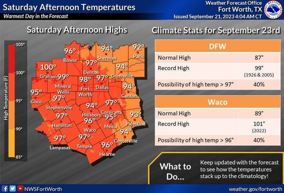
Most of Saturday will be dry with afternoon highs in the low to mid-90s. By Saturday evening, more scattered showers and isolated severe storms will break out anywhere across North Texas. Once again, quarters and Gusty wind will be the threats.These storms will weaken as they move into East Texas by daybreak Sunday.
 National Weather Service - Fort Worth
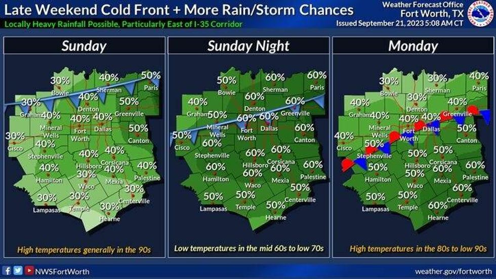
Most of Sunday will be okay until we get into the evening hours, as a cold front will drift into the area. Widespread shower and thunderstorm activity will break out across parts of North Texas. Right now it looks like the greatest threat and the heaviest rain will fall south of Interstate 20. Afternoon highs will once again be in the low to mid 90s.
Next Monday through Wednesday look dry, with the exception of a few morning showers on Monday. Lower relative humidity and cooler temperatures will slowly arrive. Monday, we'll warm into the upper 80s, but we'll cool into the low to mid 80s on Tuesday and Wednesday. Morning lows will fall into the 60s on Monday and especially on Tuesday and Wednesday. There MAY be some 50s felt by Wednesday morning.
*Yest Rain: 0.00"; Yest High: 94; Low: 71
*Today's Averages: High: 87; Low: 67
*Record high: 99 (1956): Record low: 45 (1983)
*September Rain: 0.60"; Deficit: 1.32
*2023 Rain: 15.43"; Deficit: 11.04
*Sunrise: 7:16am; Sunset: 7:26pm
Today: Partly cloudy, warm and breezy. Scattered late afternoon and evening severe storms, mainly north of DFW. Threats: Quarters and damaging wind. High: Low to mid 90s. Wind: South 15-25 mph.
Tonight: Cloudy, breezy and mild. Scattered strong and isolated severe storms, mainly north of Interstate 20. Threats: Small hail and damaging wind. Low: 68-73. Wind: South 10-20 mph.
Friday: Morning showers, then a slight chance of afternoon and evening showers ans storms, mainly east of the Mid Cities. High: Low 90s.
Saturday: *First day of Fall (1:50am)* Partly cloudy, warm and windy. Scattered strong and isolated storms by evening. Threats: Quarters and damaging wind. High: Low to mid 90s. Wind: South 10-20 mph.
Sunday: Partly cloudy, windy and warm. Scattered late day showers and storms. Some severe. High: Mid 90s.
Monday - Wednesday: Mostly sunny, cooler with lower humidity. Highs: Mid 80s.
LISTEN on the Audacy App
Tell your Smart Speaker to "PLAY 1080 KRLD"
Sign Up to receive our KRLD Insider Newsletter for more news
Follow us on Facebook | Twitter | Instagram | YouTube


