
Good Tuesday morning, my friends! Welcome to your 1080 Weather Forecast.
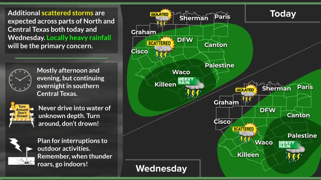
The radar is quiet across North Texas right now, but that won't last. We'll begin to see scattered showers and thunderstorms develop to our south and spread northward through this afternoon and evening. Right now, it looks like the highest coverage will be along and south of Interstate 30.
The main threats today will be frequent lightning, heavy downpours, and gusty winds. High temperatures will reach near 90° where the sun breaks out, stay in the 80s under the clouds, and remain in the 70s where rain is falling.
An upper-level disturbance remains nearly stationary to our southwest. It's the same system responsible for the major flooding across parts of the Hill Country and West Texas. Over the next 72 hours, several spokes of energy will rotate around this system and move into North Texas Wednesday, Thursday, and possibly Friday.
Combined with daytime heating, these disturbances will trigger scattered showers and thunderstorms each afternoon. Once again, very heavy rainfall, frequent lightning, and isolated flooding will be the primary concerns. I also wouldn't be surprised if one or two storms become strong enough to produce damaging wind gusts.
Our temperature pattern won't change much through the end of the week—near 90° in the sunshine, 80s under the clouds, and 70s where it's raining.
As we head into the weekend, this upper-level low will finally move west of the Lone Star State, allowing high pressure to build overhead. That sinking air will shut down our rain chances and send temperatures climbing back into the mid-90s this weekend and the upper 90s by early next week.
Because of all the recent rainfall, humidity levels will be much higher, pushing afternoon heat index values to 100° or higher even though actual air temperatures remain in the 90s.
Finally, please keep our friends in the Hill Country and West Texas in your thoughts and prayers. The flooding there is extremely serious and is only beginning. This is not a 24-hour event—it will likely be a 72-hour flood event, with repeated rounds of heavy rain falling over the same areas.
I'm Meteorologist Dan Brounoff. Have a safe Tuesday, and I'll keep you updated throughout the day.
7-Day Headlines:
- DFW Airport hit 99 degrees on Monday
- Record daily rainfall yesterday: 1.29”
- Scattered showers and storms through Friday
- Pockets of heavy rain
- HIghest coverage south of I-30
- Threats: Isolated flooding, lightning, gusty wind
- Hot and dry this weekend
- Download our AUDACY app! Listen to KRLD LIVE at home or at work
Almanac:
- Yest Rain: 1.29”; Yest High: 90; Low: 28
- Today’s Averages: High: 95; Low: 76
- Record high: 107(1925); Record low 62 (1990)
- July rain: 1.29”; Surplus: 0.16”
- 2026 Rain: 22.54”; Snow: 2.4”; Surplus: 1.12”
- Sunrise: 6:31am; Sunset: 8:37pm
Forecast:
Tuesday: Partly cloudy, warm and humid. Scattered late day showers and storms. Highest coverage south of I-30. High: Near 90. Wind: SE 5-101 mph.
Tuesday night: Partly cloudy, and humid. A few leftover showers. Low: Mid 70s. Wind: SE 5-10 mph.
Wednesday: Partly cloudy, warm and humid. Scattered showers and storms. High: Mid to upper 80s. Wind: SE 5-10 mph.
Thursday: Mostly to partly cloudy, warm and humid. Scattered showers and storms. High: Upper 80s.
Friday: Partly cloudy, warm and humid. Isolated late day showers and storms. High: Near 90
Weekend: Partly cloudy, hot and humid. Highs: Mid 90s.
Monday: Mostly sunny, hot and humid. High: Mid 90s.
LISTEN on the Audacy App
Tell your Smart Speaker to "PLAY 1080 KRLD"
Sign Up to receive our KRLD Insider Newsletter for more news
Follow us on Facebook | Twitter | Instagram | YouTube