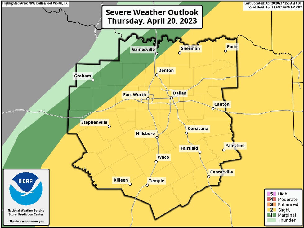
A Severe Thunderstorm Watch is in effect for parts of North Texas until 9 p.m., according to the National Weather Service.
The Watch is in effect for Anderson, Delta, Fannin, Freestone, Henderson, Hill, Hopkins, Kaufman, Lamar, Navarro, Rains, Red River, and Van Zandt counties until 9 p.m. Thursday.
We're waking up to the warm and muggies this morning, as temperatures have only fallen to near 70゚. At 6am this morning, a cold front is rapidly moving our direction from the northwest. It will arrive in north Texas close to lunchtime sparking showers and storms.
As of now, it looks like the greatest severe weather threat will be just south and east of DFW after 3pm, lasting through this evening. Please keep in mind that one or two storms may form right on top of DFW before 3pm. Threats: Damaging wind, large hail, and isolated tornadoes.
 National Weather Service
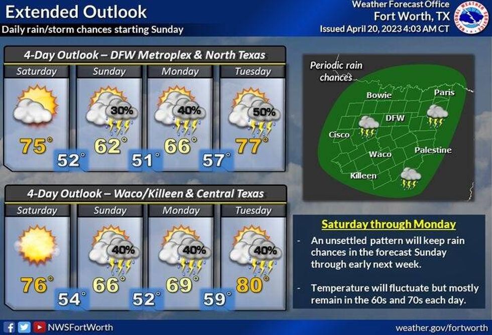
Cooler temperatures and a few scattered showers and isolated storms will continue overnight through tomorrow morning, but nothing severe is expected. Morning lows will range from 50 degrees to 60 degrees, with the coolest temperatures along the Red River counties.
After some morning showers early Saturday, skies will slowly clear through the day. Highs will reach the low 70s.
 Naitional Weather Service - Fort Worth
Saturday looks uneventful with increasing clouds by the late afternoon and evening. Highs once again be in the low seventies.
By Saturday night into early Sunday, another cold front will move into the area. Scattered showers and a few rumbles of thunder are possible by daybreak. Morning lows will be in the fifties.
Sunday through Tuesday: Off and on chilly rain and cool temperatures. Afternoon highs will only be in the sixties on Sunday, we may not get out of the upper fifties on Monday. Readings will jump back into the low seventies by Tuesday. Our average high this time of the year is seventy-seven degrees.
Another cold front will sweep through here on Wednesday, bringing a chance of rain as well as cooler temperatures.
*Yest Rain: 0.00"; Yest High: 85 Low: 66
*Today's Averages: High: 77; Low: 56
*Record high: 94 (1925); Record low: 40 (1953, 2021)
*April Rain: 0.60"; Deficit: 1.30"
*2023 Rain: 8.71"; Deficit: 1.78"
*Sunrise: 6:53am; Sunset: 8:02pm
Today: Mostly cloudy, windy and warm. Scattered strong and severe storms. Possible Storm Watch today. Threats: Large hail, damaging wind, isolated tornadoes. High: Low to mid 80s. Wind: South to north 15-25, G30 mph.
Tonight: Cloudy, windy and cool. Scattered showers and non severe storms. Low: 50 to 60. Wind: North 10-15 mph.
Friday: Morning showers, afternoon sunshine. Pleasant. High: Low to mid 70s. High: Low to mid 70s. Wind: North 10-20 mph.
Saturday: Sunny and cool, then increasing clouds. Chance of showers by late evening. High: Low to mid 70s.
Sunday: Cloudy and cool. Scattered showers. Highs: Low 60s.
Monday: Cloudy and cool. Scattered showers. High: Low to mid 60s.
Tuesday: Mostly cloudy and mild. Scattered showers. HIgh: Low to mid 70s.
Wednesday: Mostly cloudy and pleasant. Isolated showers. High: Low 70s.