


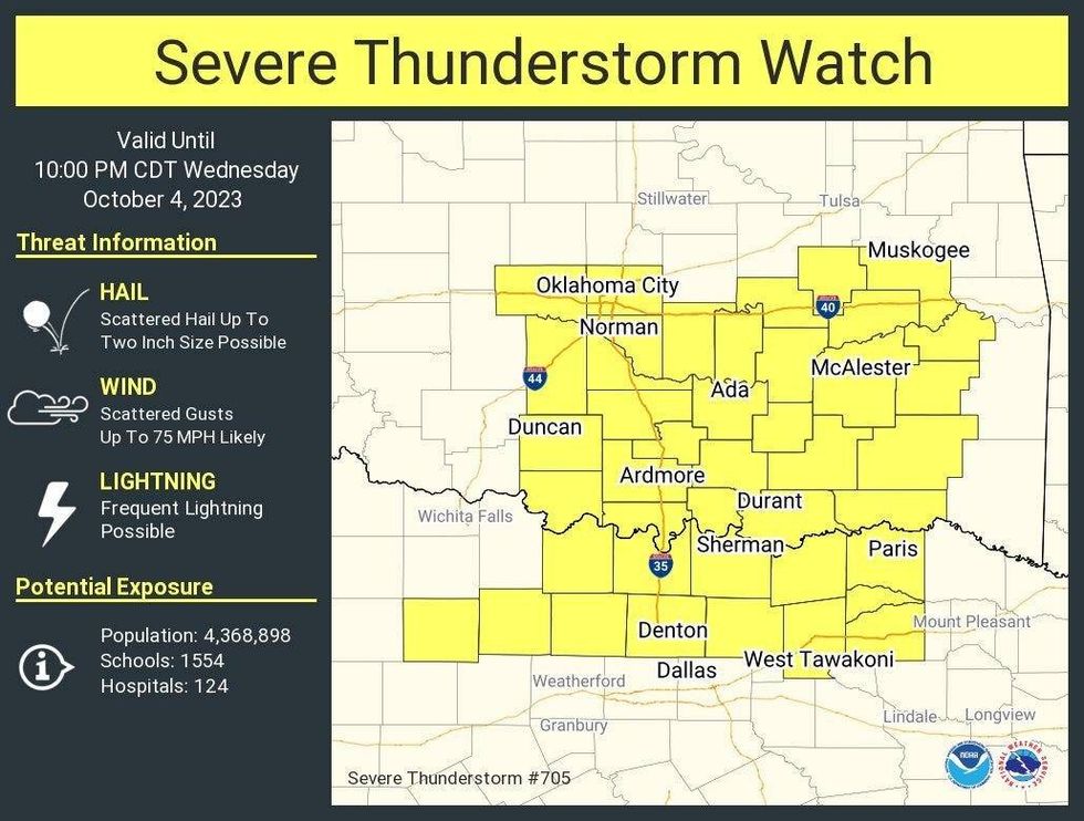
A Severe Thunderstorm Watch is in effect for large swaths of Dallas-Fort Worth through 2 a.m. Thursday morning. Flash Flood Warnings were issued for parts of Dallas, Rockwall, and Tarrant counties.
Wednesday morning was quiet across North Texas but clouds invaded the area and humidity levels rapidly increased overnight. Wednesday morning Temperatures were mainly in the mid to upper 70s.
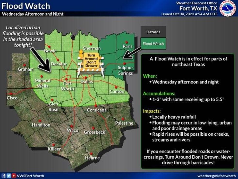
Due to the rain in East Texas during the day Wednesday, a Flash Flood Watch was issued northeast of the Dallas-Fort Worth area overnight. This is where 3 to 4 inches of rain could fall by Thursday morning.
 National Weather Service - Fort Worth
Flooding is a concern around the Red River Valley, the northern Big Country, and off the Caprock in West Texas. Anywhere between 2 to 5 inches of rain has fallen and at least another 2 to 3 is on the way.
This large area of showers of storms will start to drift southeast in the next three hours and will arrive across north Texas between 9 p.m. and 1 a.m. from northwest to southeast. A few severe storms are possible but I'm not overly concerned.
Just about everyone will see at least an inch of rain here, with isolated higher totals possible.
These showers and storms will form along a cold front later this afternoon to the northwest of DFW. This front will head southeast through this evening and overnight producing widespread shower and thunderstorm activity.
 National Weather Service - Fort worth
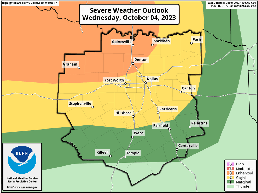
The enhanced risk of level three (in orange) is still stretched out to include the northwestern quadrant of north Texas now. Threats: Quarters and damaging wind in the orange between 9:00 p.m. and 3:00 a.m. from northwest to southeast, earlier with larger hail northwest of a Bowie to Breckenridge line, pocket change size hail and damaging wind in the yellow or slight risk area between 9:00 p.m. and 3:00 a.m. as well.
A level 2 remains in place across parts of north Texas for this evening into the early morning hours. Threats: Small hail and isolated damaging wind.
There's also a chance for some isolated flooding overnight, especially near creeks and streams and in low-lying areas.
 National Weather Service - Fort worth
The bulk of the rain will head south of DFW by late morning tomorrow with slow clearing by late afternoon. Most of north Texas will pick up at least an inch of rain with some isolated 2-inch totals not out of the question.
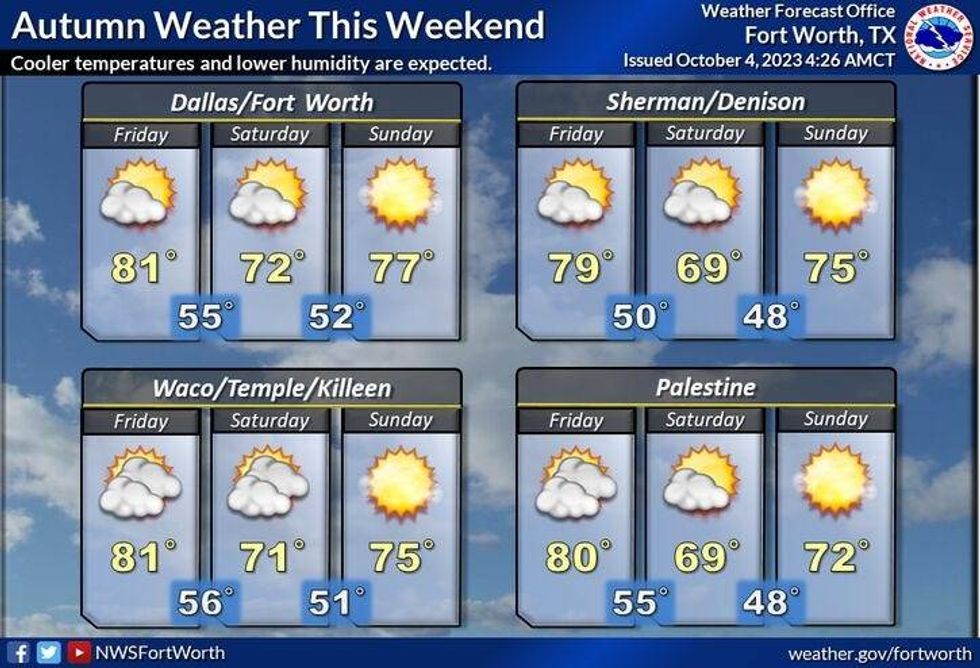
Morning lows tomorrow will drop into the mid to upper 60s, with afternoon highs near 80° behind the first cold front. A second cold front will arrive the second half of Friday ushering in much cooler air just in time for the weekend. I still think we'll hit the low 80s on Friday, but temperatures will drop to near 70 for a high on Saturday, mid-70s on Sunday. Morning lows will be in the 50s! It's going to feel terrific this weekend. Temperatures will warm back into the low to mid-80s into early next week.
 National Weather Service - Fort worth
*Yest Rain: 0.00"; Yest High: 92; Low: 71
*Today's Averages: High: 83; Low: 62
*Record high: 96 (1898, 1925, 1983): Record low: 45 (1987)
*October Rain: 0.00"; Deficit: 0.31"
*2023 Rain: 15.66"; Deficit: 11.92"
*Sunrise: 7:24am; Sunset: 7:09pm
Today: * Flood Watch NE of DFW* Mostly to partly cloudy and warm. Scattered showers and strong storms stay mainly in east Texas. High: Near 90. Wind: South 10-15 mph.
Tonight: * Flood Watch NE of DFW* Numerous showers and storms, some may become severe. Threats: Damaging wind and small hail. Rain totals: 1.00" - 2.00". Low: Mid to upper 60s.. Wind: NE 10-15 mph.
Thursday: Morning rain, then slow clearing by late afternoon and evening. High: Near 80. Wind: North 10-20 mph.
Friday: Sunny and pleasant. Late day cold front. High: Low 80s.
Saturday: Partly cloudy, breezy and cool. Texas/OU 11:00am kickoff temp: Mid 60s. Low: Mid to upper 50s; High: Near 70.
Sunday: Sunny and perfect! Low: Low to mid 50s; High: Mid to upper 70s.
Columbus Day: Mostly sunny and nice. High: Low 80s.
Tuesday: Partly cloudy, breezy and warmer. High: Mid 80s.
LISTEN on the Audacy App
Tell your Smart Speaker to "PLAY 1080 KRLD"
Sign Up to receive our KRLD Insider Newsletter for more news
Follow us on Facebook | Twitter | Instagram | YouTube


