


We're starting Thursday with temperatures in the upper sixties to low seventies, with nothing showing on radar.
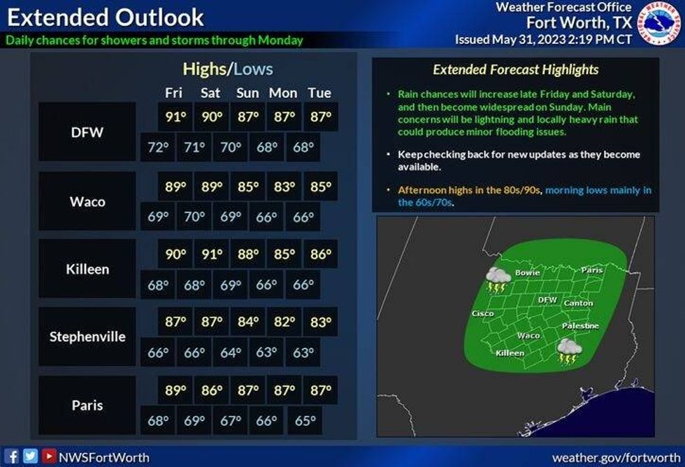
Plenty of sunshine today and tomorrow with high temperatures near 90 degrees. Also, today is day one of the 2023 hurricane season. Hurricane season lasts through November 30th.
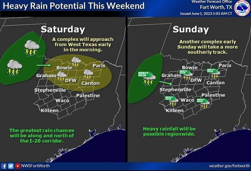
A cluster of storms will approach north Texas early Saturday morning in a weakened state, but more showers and storms will develop during the afternoon and evening. High temperatures will reach the upper eighties.
 National Weather Service - Fort Worth
Our best chance of rain is on Sunday. Widespread shower thunderstorm activity will impact much of north Texas. Some of the rain could be heavy at times. Afternoon highs will be in the low to mid eighties.
More scattered storms are in the forecast on Monday and Tuesday, mainly during the late afternoon and evening hours. Afternoon highs will warm into the mid two upper eighties. Isolated late day storm chances continue on Wednesday, with highs in the upper eighties.
 National Weather Service - Fort Worth
*Yest Rain: 0.00"; Yest High: 90; Low: 66
*Today's Averages: High: 89; Low: 69
*Record high: 102 (1911): Record low: 48 (1903)
*May Rain: 2.35"; Deficit: 2.43"
*2023 Rain: 13.58"; Deficit: 3.01"
*Sunrise: 6:21am; Sunset: 8:31pm
Today: *Air Quality Alert* Partly cloudy, hazy and warm. High: Near 90. Wind: SSE 5-10 mph.
Tonight: Partly cloudy and mild. Low: 68-72. Wind: SSE 5-10 mph.
Friday: Partly cloudy, hazy and seasonable. Weakening storms arrive after midnight. High: Near 90.
Weekend: Partly to mostly cloudy and warm. Scattered showers and storms, widespread rain on Sunday. Highs: Mid to upper 80s.
Monday: Partly cloudy and warm. Scattered showers and storms. High: Mid 80s.
Tuesday and Wednesday: Partly cloudy and warm. Isolated showers and storms. High: Mid to upper 80s.

LISTEN on the Audacy App
Tell your Smart Speaker to "PLAY 1080 KRLD"
Sign Up and Follow NewsRadio 1080 KRLD


