Three cold fronts, minimal precipitation, cold mornings, and cool afternoons are the prevailing weather patterns across North Texas over the next 7 days. There is a possibility of rain returning to the area late Tuesday of next week.
Good morning, and I appreciate your continued support. I take pride in providing accurate North Texas forecasts without sensationalism, backed by over 50 years of experience in monitoring North Texas weather.
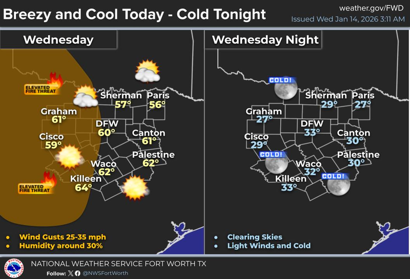
A cloud bank accompanying a windy cold front is moving rapidly southward, bringing temperatures down to the 40s, with wind gusts reaching 25 mph throughout the morning. As the sun warms the Earth's surface today to near 60 degrees, wind gusts may reach 35 mph, posing a high grass fire danger. Please ensure cigarette butts are properly extinguished in a half-filled bottle of water inside vehicles.
Tonight, temperatures will drop to between 28 and 35 degrees after midnight, necessitating the protection of pets and tender vegetation.
A south wind will return tomorrow, gusting up to 15 mph, warming temperatures into the mid-to-upper 60s. Notably, the average high temperature this time of year is 56 degrees, while the average low is 36 degrees, marking the coldest averages experienced during the winter season.
Our second cold front will arrive around lunchtime on Friday, accompanied by few clouds but no precipitation. Afternoon highs will reach 60 degrees, with windy conditions making it feel like the low 50s.
The wind will subside on Saturday, with passing high clouds, and temperatures will be cooler, ranging from the low to mid-50s. Sunday will be equally pleasant, with a light freeze expected in the morning, and highs reaching the upper 50s by afternoon.
Monday will be relatively quiet, with increasing clouds late in the day, relaxed winds, and high temperatures warming into the low 60s. By Monday night, the third cold front will arrive, bringing cloud cover but no precipitation.
Clouds will continue to thicken on Tuesday, leading to a mostly cloudy and chilly day, with afternoon highs reaching only 50 degrees. There are indications of a disturbance arriving Tuesday night, potentially bringing rainfall, although it is too early to predict coverage and amounts. Stay informed for updates.
That concludes my weather report for this mid-January morning. I hope you have a blessed day and enjoy the weather when you can, it's the only weather you've got.
7-Day Headlines:
* DFW Airport reached 67 yesterday.
* Three DRY cold fronts through next Monday.
* First front this morning.
* Second front Friday.
* Third front next Monday.
* No rain for a while.
* Chilly mornings and cool afternoons though the weekend; Seasonable weather.
*Yest Rain: 0.00”; Yest High: 67; Low: 41
*Today’s Averages: High: 56; Low: 36
*Record high: 79 (1928, 2022); Record low: 4 (1964)
*January Rain: 0.01"; Deficit:
*2026 Rain: 0.01"; Deficit:
*Sunrise: 7:31am; Sunset: 5:45pm
Wednesday: Mostly to partly cloudy, windy and cool. High: Near 60. Wind: NW 15-25, G35 mph.
Wednesday night: Clear and chilly. A light freeze away from DFW. Low: 28-35. Wind: North 5-10 mph.
Thursday: Mostly sunny and breezy. High: Near Mid 60s. Wind SW 5-10 mph.
Friday: Mostly sunny, windy, and cool. Lunchtime cold front. High: Near 60.
Saturday: High clouds and cool. High: Low 50s.
Sunday: Sunny, breezy and cool. High: Upper 50s.
Monday: Increasing clouds, remaining cool. High: Low 60s.
Tuesday: Mostly cloudy and chilly. Showers late? High: Near 50.
LISTEN on the Audacy App
Tell your Smart Speaker to "PLAY 1080 KRLD"
Sign Up to receive our KRLD Insider Newsletter for more news
Follow us on Facebook | Twitter | Instagram | YouTube
