A jacket or a hoodie is necessary this morning as temperatures have fallen into the upper 30s to mid-40s across the area. That's what a calm wind and a clear sky will do as a chilly surface high pressure settles directly overhead this morning.
This area of high pressure will continue to slide east through the day today and southerly winds will slowly return. If you're new to the area, a southerly wind is a warming wind any time of the year. Plenty of sunshine will be enjoyed today with afternoon highs warming into the low to mid 70s.
The south winds pick up tonight so we won't be as cool, but it'll still be nice for this time of the year. Readings will drop into the low to mid 50s.
Tomorrow will be a breezy day with southerly winds gusting to 30 mph. This will warm temperatures up into the low 80s. There will also be a high grass fire danger west of I-35W.
 National Weather Service - Fort Worth
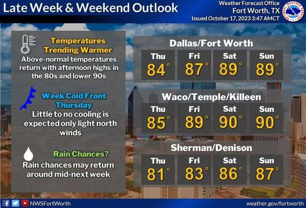
Low 80s will be popular Thursday and Friday as well. There will be a weak cold front coming into the area Thursday evening keeping the air dry, the mornings cool and the afternoons a bit above average. Average high this time of the year is 78°. Our average high will drop to 72° by Halloween.
The past couple of weekends have been rather cool, but this last weekend of the State Fair of Texas will be rather warm and breezy. Mostly cloudy on Saturday with highs in the upper 80s. Sunshine returns Sunday with readings jumping up into the low 90s. More cloud cover, humidity, and wind will keep temperatures in the mid to upper 80s on Monday, but it will be very muggy.
I'm sure you've noticed that not one time have I mentioned the word rain over the next seven days. Terrible news. However, some of the extended data I've been analyzing shows rain returning to the area by the middle of next week.
*Yest Rain: 0.00"; Yest High: 67; Low: 48
*Today's Averages: High: 78; Low: 57
*Record high: 95 (1972): Record low: 41 (1976)
*October Rain: 1.04"; Deficit: 0.96
*2023 Rain: 16.70"; Deficit: 12.42
*Sunrise: 7:34am; Sunset: 6:53pm
Today: Sunny and perfect! A south wind slowly returns. High: Mid 70s. Wind: South 5-10 mph.
Tonight: Clear and cool, but not as cool as the past few mornings. Low: Low to mid 50s. Wind: South 10 mph.
Wednesday: Sunny, windy and warmer. Grass fire danger west of I-35. High: Low 80s. Wind: South 10-20, G30 mph.
Thursday and Friday: Sunny, breezy and nice. High: Low 80s.
Weekend: Mostly to partly cloudy and warm. Highs: Near 90.
Monday: Mostly cloudy, windy, muggy and warm. High: Mid to upper 80s.
LISTEN on the Audacy App
Tell your Smart Speaker to "PLAY 1080 KRLD"
Sign Up to receive our KRLD Insider Newsletter for more news
Follow us on Facebook | Twitter | Instagram | YouTube