


There are a couple of more mild days ahead before the bottom drops out on Sunday. Next week's temperatures will be well below average, and there's a chance for precipitation starting Wednesday.
Temperatures fell into the low to mid-40s on Friday morning and North Texas will see a mix of sun and clouds today with afternoon highs reaching the low 60s.
Clouds will roll in overnight and there could be some patchy drizzle or light rain, especially from Dallas to the east Saturday morning. Temperatures will fall into the mid to upper 40s. Mostly cloudy Saturday with afternoon highs near 60 degrees.
The drizzle could return on Sunday morning and there will be a few showers around as the Arctic front arrives close to 12 p.m. The best chance for rain will be east of Dallas into east Texas. Temperatures will warm into the low 60s before noon and then sharply drop to near freezing by 9 p.m. Temperatures will continue to tumble into the mid to upper 20s on Monday morning. Factor in the 30 mph, wind chills will be in the teens.
The sun will be out on Monday and Tuesday but it will be cold. Afternoon highs will approach 40 degrees each day. Morning lows will fall into the mid to upper 20s.
A strong upper-level low will dig into the desert southwest on Wednesday. Lots of things have to come together for us to see a major winter storm in North Texas. Because so many factors have to come into place, I'm holding off on predicting a winter storm in North Texas. Will there be precipitation across the state? Yes! Will it be rain, sleet, or snow? There's no way of telling yet.
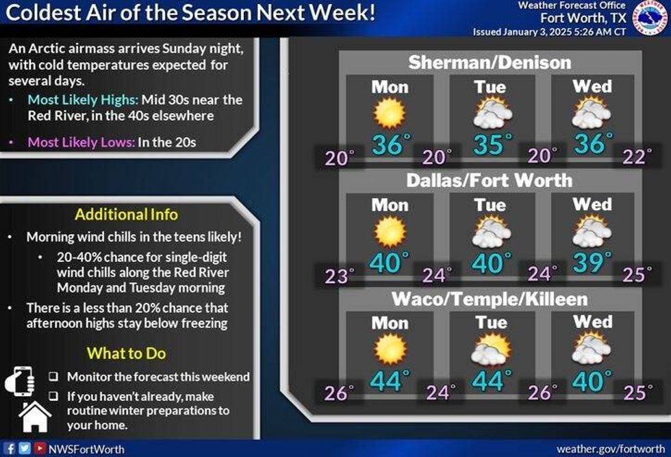 North Texas temperatures next weekNational Weather Service
7-Day Headlines
* DFW Airport reached 61 on Thursday.
* A nice day Friday, clouds roll in late in the day.
* A few showers and areas of drizzle on Saturday.
* The Arctic blast arrives by Sunday afternoon. A few showers along the front.
* Sharply colder into Monday morning.
* Cold air sticks around throughout the week
* Watching for rain or wintry mix late Wednesday - Friday.
_____________________________________________________
*Thursday Rain: 0.00"; Thursday High: 61; Low: 35
*Friday's Averages: High: 56; Low: 36
*Record high: 84 (2006, 2009); Record low: 4 (1911)
________________________________________________________
*January Rain: 0.00"; Deficit:
*2025 Rain: 0.00"; Deficit:
*Sunrise: 7:31am; Sunset: 5:35pm
________________________________________________________
Friday: Partly cloudy and cool. High: Low 60s. Variable 5-10 mph.
Friday night: Partly cloudy and cool. Low: 43-50. SE 5-10 mph.
Saturday: Mostly cloudy and cool. Patchy drizzle throughout the day. High: Near 60. Wind: SE 15-25 mph.
Sunday: Morning showers, then mostly clear, turning windy and MUCH colder in the afternoon. High: Low 60s early, falling to near freezing by 9 p.m.
Monday: Mostly sunny, windy and cold. High: Upper 30s.
Tuesday: Partly to mostly cloudy and cold. A few snow flurries NW of DFW. Low: 20s; High: Near 40.
Wednesday: Increasing clouds and cold. Slight chance of precipitation. High: Mid to upper 30s.
Thursday: Cloudy and chilly. Chance of a cold rain, possibly a wintry mix. High: Mid to upper 30s.
LISTEN on the Audacy App
Tell your Smart Speaker to "PLAY 1080 KRLD"
Sign Up to receive our KRLD Insider Newsletter for more news
Follow us on Facebook | Twitter | Instagram | YouTube


