A tranquil morning is unfolding on the home front, but as we transition into April tomorrow, the threat of severe weather intensifies across North Texas. I anticipate two opportunities for severe weather: initially late tomorrow evening and again late Friday into Saturday noon.
Good morning, and welcome to Tuesday. We are waking up to considerable cloudiness, pleasant conditions, and temperatures ranging from the mid to upper 60s. A gradual clearing is expected throughout the day, with afternoon highs reaching the mid-80s once again. A south wind will blow at 15 to 25 mph, with gusts up to 30 mph.
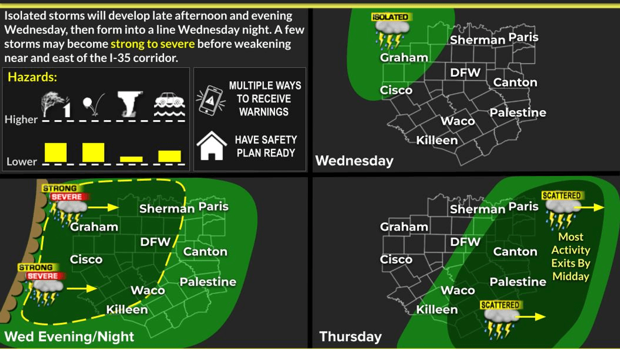
A similar forecast is expected for Wednesday, with a notable change occurring Wednesday evening as a line of showers and storms develops to our west and moves through the area before midnight. I anticipate gusty winds, small hail, and isolated tornadoes. Conditions will calm down before daybreak Thursday.
Thursday and Friday are expected to be relatively quiet, with ample afternoon sunshine and afternoon highs reaching the mid to upper 80s. A south wind will continue to blow at 15 to 25 mph, with gusts up to 30 mph. Morning clouds and partial afternoon sun can be expected on Friday, with isolated showers possible during the day.
Another line of showers and storms will move through the area Friday evening, with all modes of severe weather possible. Afternoon highs on Friday will reach the mid to upper 80s.
A cold front will approach the area during the first half of Saturday, producing another area of showers and storms, with all modes of severe weather possible once again. This front should be southeast of us after the noon hour, taking the rain with it. Clearing will be slow late Saturday, with afternoon highs cooling into the 50s, warming into the 60s by afternoon.
Easter Sunday morning will bring some clouds, with rapid clearing by late morning. Breezy conditions will prevail, with temperatures falling into the mid to upper 40s. Afternoon highs will only reach the mid-60s, with plenty of sunshine.
7-Day Headlines:
- DFW Airport reached 85 on Tuesday.
- A windy week ahead.
- Above average temperatures until the weekend.
- Scattered severe storms late Wednesday, and late Friday through noon Saturday.
- Threats: Hail, wind, isolated tornadoes.
- Strong lunchtime cold front Saturday.
- A cool, sunny, and breezy Easter Sunday.
Almanac:
- Today’s Averages: High: 73; Low: 52
- Record high: 96 (1974); Record low 28 (1987)
- March rain: 2.92”; Deficit: <0.28”>
- 2026 Rain: 5.16”; Snow: 2.4” Deficit: <3.33”>
- Sunrise: 7:16am; Sunset: 7:48pm
7-Day Forecast:
- Tuesday night: Increasing clouds, breezy and mild. Low: Mid to upper 60s. Wind: South 15-25 mph.
- Wednesday: Morning clouds, afternoon sun. Windy and warm. High: Mid 80s. South 15-25, G30 mph.
- Wednesday night: Weakening Texas squall line blows through after 10pm. Threats: Small hail, gusty wind, and lightning. Low: Low to mid 60s.
- Thursday: Morning showers, then partly cloudy and warm. High: Mid 80s.
- Friday: Morning clouds, afternoon sun. Windy and warm. Showers and isolated severe storms arrive by evening. Threats: Hail, gusty wind, an isolated tornado. High: Mid to upper 80s.
- Saturday: Morning showers and storms are a good bet. Heavy rain and severe threat drifts south after lunch. Late morning cold front. Slow clearing, windy and cooler. High: 70 early, 50s by lunch, 60s by afternoon.
- Easter Sunday: Sunny, windy and cool. Low: mid to upper 40s. High: Mid 60s.
- Monday: Sunny and beautiful. High: Low 70s.