A Tornado Watch has been issued for parts of North Texas until 9 this evening. According to the National Weather Service, damaging winds, 1-inch hail and a few tornadoes are all possible. However, the Tornado Watch has been canceled for certain counties including Erath, Hood, Jack and Wise.
North Texas will see pockets of light rain Friday morning, a line of showers from 3-6 p.m., and a beautiful weekend to follow. Some of the afternoon storms could be severe with small hail and strong wind.
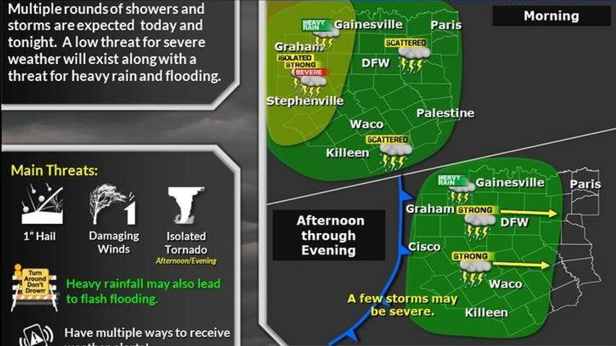
Flooding rain fell overnight and into Friday morning west and northwest of the Dallas-Fort Worth area. Some areas received between 4 and 7 inches of rain. Flash Flood Warnings continued in Wise and Jack counties through the early morning hours and a Flash Flood Watch will be in effect until 9 p.m.
Friday started with areas of drizzle and some light rain showers across North Texas and temperatures in the mid to upper 60s.
The powerful storm system that's giving unusually high snow totals across northern New Mexico and eastern Colorado will start to move across North Texas Friday afternoon and evening. A line of showers and storms, some of which may become severe, will move across the area between 3 p.m. and 9 p.m. Pocket change-sized hail and some damaging wind are the threats, but warnings will be few and far between. The tornado threat is never zero but is low. Afternoon highs will top out near 70 degrees.
Saturday morning will feature a clear sky and temperatures in the mid to upper 50s. Cooler, drier air will continue to filter into the area during the day. Afternoon highs will reach 70 degrees.
Temperatures will be back in the 50s for Sunday morning. Plenty of sunshine will greet us with afternoon highs in the mid-70s.
Next week, things will start off clear and dry. Morning lows will be in the 50s and afternoon highs in the mid to upper 70s. We might even hit 80 on Tuesday in some areas.
The next cold front arrives the first half of Wednesday bringing a slight chance of showers and storms with it. Afternoon highs will reach the low 70s on Wednesday, but cooler, drier air will greet us on Thursday and Friday with plenty of sunshine.
7-Day Headlines
* DFW Airport reached 73 on Thursday.
* Scattered showers and strong storms from 3-9 p.m. Friday. Wind and quarter-sized hail.
* A beautiful weekend ahead.
* Warming up into Monday and Tuesday.
* Wednesday morning cold front,
* A few showers and storms early Wednesday.
* Cooler on Thursday and Friday.
_____________________________________________________
*Thursday Rain: 0.00"; Yest High: 73; Low: 51
*Friday's Averages: High: 70; Low: 49
*Record high: 88 (1963, 1988); Record low: 28 (1959)
_________________________________________________________
*Novemeber Rain: 1.30; Surplus: 0.64"
*2024 Rain: 35.45"; Surplus: 3.15"
*Sunrise: 6:53am; Sunset: 5:31pm
________________________________________________________
Friday: Cloudy and cool. Morning showers, afternoon and evening strong storms. Threats: Pocket change hail and damaging wind. High: Near 70. Wind: ESE 15-25 mph.
Friday night: Evening showers and storms. Ending before midnight. Cooler. Low: Mid to upper 50s.Wind: NE 10-20 mph.
Saturday: Sunny and perfect. High: Near 70. Wind: Variable 5-10 mph.
Sunday: Sunny and pleasant. High: Mid-70s.
Monday and Tuesday: Sunny and warmer. Highs: Upper 70s.
Wednesday: Morning clouds, with scattered showers and storms, becoming sunny by afternoon. Breezy and cooler. High: Low 70s.
Thursday: Sunny and beautiful. High: Near 70.
LISTEN on the Audacy App
Tell your Smart Speaker to "PLAY 1080 KRLD"
Sign Up to receive our KRLD Insider Newsletter for more news
Follow us on Facebook | Twitter | Instagram | YouTube