Two large areas of showers and isolated severe storms are moving toward North Texas. On Thursday morning, the first cluster was approaching Wichita Falls and the second cluster was in the Texas Panhandle. Both clusters will merge together and drift across the area through the afternoon. Some of these storms may become severe.
There's also a risk of flash flooding, but the tornado threat and the large hail threats are very low. By Thursday evening, most areas will have picked up at least an inch or two of rain. Afternoon highs will reach the low 80s.
As another cluster of storms forms in West Texas, more storms are possible late Thursday night through early Friday morning. This morning and afternoon event may stabilize the atmosphere slightly and allow the overnight complex to weaken as it approaches North Texas after midnight. If it stays strong, damaging wind, small hail, and flooding will be the threats. Lows will dip in the mid to upper 60s.
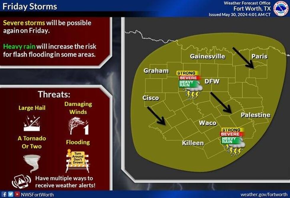 North Texas storm chances for Friday, May 31, 2024.National Weather Service
More storms are possible Friday afternoon and evening, with the heaviest rain southeast of DFW. Afternoon highs will struggle to hit 80 degrees.
More waves of heavy rain, some of which may become severe, are possible this weekend. It's hard to pinpoint the exact coverage area, severe risk, and rainfall totals. There are lots of variables that are in play. Afternoon highs will be in the mid-80s this weekend.
There will be a storm threat Monday into early Tuesday with highs near 90 degrees both days. As temperatures and humidity heat up, things will start to dry out after Tuesday morning.
 Severe weather outlook for Saturday, June 1, 2024.National Weather Service
7-Day Headlines
* DFW Airport reached 88 Wednesday.
* Waves of heavy rain through the weekend. Flooding is a big concern.
* Severe storms are possible. Damaging wind, some hail, an isolated tornado.
* 2-4 inches of rain on the way through the weekend.
* Scattered storms continue through early next week.
* Temperatures near 90 starting Monday.
_____________________________________________________
*Wednesday Rain: 0.00"; Yest High: 88; Low: 70
*Thursday's Averages: High: 88; Low: 69
*Record high: 103 (1985) Record low: 47 (1947)
______________________________________________________
*May Rain: 5,96"; Surplus: 1.48"
*2024 Rain: 23.23"; Surplus: 6.94"
*Sunrise: 6:21am; Sunset: 8:31pm
______________________________________________________
Thursday: Scattered showers and storms, some severe. Threats: Damaging wind, some hail, an isolated tornado, and flash flooding. High: Low 80s. Wind: SE 10-25 mph.
Thursday night: Scattered severe storms towards midnight. Threats: Damaging wind, some hail, an isolated tornado, and flash flooding. Low: Mid to upper 60s. Wind: SE 10-20 mph.
Friday: Rain before noon, then mostly cloudy and decent. More storms by evening. some severe. Threats: Wind, hail, and areas of flooding. High: Near 80. Wind: SE 10-15 mph.
Saturday: Partly cloudy, warm and humid. More storms are possible late—high: Mid-80s.
Sunday: Partly cloudy, warm and humid. Scattered showers and storms. High: Mid to upper 80s.
Monday: Partly cloudy, warm and humid. Scattered showers and storms. High: Near 90.
Tuesday: Morning storms, then partly cloudy, warm and humid. High: Near 90.
Wednesday: Partly cloudy, warm and humid. High: Near 90.
LISTEN on the Audacy App
Tell your Smart Speaker to "PLAY 1080 KRLD"
Sign Up to receive our KRLD Insider Newsletter for more news
Follow us on Facebook | Twitter | Instagram | YouTube