


On and off rain chances late Tuesday through noon Saturday. The most challenging aspects of this extended forecast are the timing, severity, and rainfall totals.
Temperatures Tuesday morning were in the low to mid-50s under a mostly clear sky. It will be a decent but windy day with afternoon highs reaching the low 80s. South winds could gust as high as 40 mph.
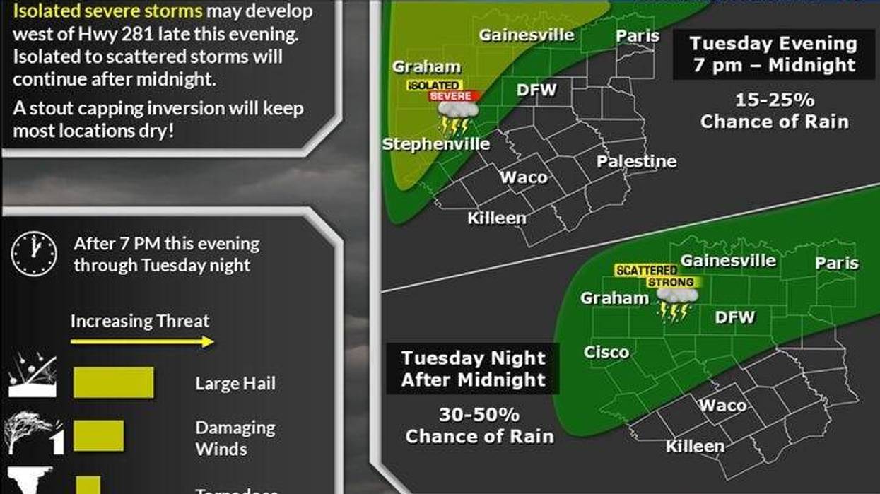
There is a threat for isolated severe storms to break out to the west and northwest of DFW late Tuesday afternoon and evening along the dry line. A strong cap will be in place across North Texas. Most of these storms will move into Oklahoma through the early morning hours. Temperatures will be mild with readings in the upper 60s Wednesday morning.
Low clouds will creep in Wednesday morning, and there might even be a few showers dotting the area. There will be peaks of sunshine during the day with a few more scattered showers and storms breaking out to the east of DFW by late afternoon and evening. Another area of showers and storms will develop to the northwest along a slow-moving cold front that will edge through the area in the first half of Thursday.
Areas along and south of the front have another chance for scattered strong to severe storms during the day and evening on Thursday. Afternoon highs will range from 65-80 from north to south. This cold front will meander in the area Thursday night into Friday. This coupled with a strong upper-level low that will slowly approach from the west will cause widespread shower and thunderstorm activity to break out during the afternoon Friday and especially overnight into noon on Saturday. Some of these storms may become severe. Heavy rain will be a big threat. Two to three inches of rain will fall across much of the area through the period, with isolated higher totals to our Northeast. Afternoon highs will range from 65 to 80 degrees on Friday.
Showers and storms with embedded heavy rain will continue through mid to late morning Saturday. Temperatures will start near 60 degrees but rapidly fall into the 40s by evening as the rain moves east, but the clouds and light drizzle linger. There might even be some light snow up towards Wichita Falls early Sunday morning, but no accumulations are expected. A different story in the Texas Panhandle, where 1-3 inches of snow could fall around Amarillo.
The skies will clear, but it will be windy and chilly on Sunday. Morning lows will dip into the upper 30s, with afternoon highs struggling to get above 50 degrees. Monday looks very nice, with lows in the upper 30s, and afternoon highs near 60 degrees. A warming trend is expected after that.
7-Day Headlines:
DFW reached 72 degrees on Monday.
Windy and warm on Tuesday. Isolated evening severe storms northwest of DFW.
Isolated severe storms late Wednesday into Thursday morning.
The best shower and storm chances, Friday into noon Saturday, some severe.
Isolated flooding threat increases late Friday.
Much colder late Saturday through Monday.
*Monday Rain: 0.00"; Monday High: 72 Low: 51
*Tuesday's Averages: High: 73; Low: 52
*Record high: 93 (1918): Record low: 31 (1899)
*March Rain: 1.67"; Deficit:
*2025 Rain: 8.71"; Surplus: 0.12"
*Sunrise: 7:14am; Sunset: 7:49pm
Tuesday: Mostly sunny, windy and warm. High: Low 80s. Wind: South 20-30, G40 mph.
Tuesday night: Increasing clouds and mild. Humid. Isolated severe storms northwest of DFW. Low: Mid to upper 60s. South 15-25, G35 mph.
Wednesday: Morning clouds and showers. Peeks of afternoon sunshine. Scattered showers and isolated severe storms by late evening, especially west of DFW. High: Near 80. Wind: South 10-20 mph.
Thursday: Scattered morning showers and storms, peeks of afternoon sun. Cold front stalls nearby. Scattered storms south of DFW. Some may be severe. High: 68-82.
Friday: Widespread showers and strong storms towards late afternoon. Areas of heavy rain. Flooding potential. High: 60-75.
Saturday: Morning showers and storms, turning windy and much colder. High: 60s early, falling into the 40s by evening.
Sunday: Mostly sunny, windy and chilly. High: Low 50s.
Monday: Mostly sunny and cool. High: Low 60s.
LISTEN on the Audacy App
Tell your Smart Speaker to "PLAY 1080 KRLD"
Sign Up to receive our KRLD Insider Newsletter for more news
Follow us on Facebook | Twitter | Instagram | YouTube


