There has been a prolonged timeframe without severe weather for this time of year in North Texas, but that will change over the weekend. Friday began with a deck of low clouds streaming in from the south, breezy conditions, and temperatures hovering near 70 degrees. Friday will be relatively quiet, with breezy conditions and peaks of afternoon sun. Afternoon highs will reach the mid-80s.
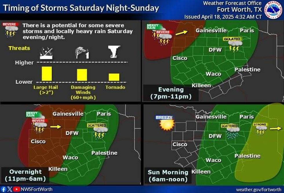
Scattered strong to severe thunderstorms will develop to the west late Friday, containing large hail, damaging winds, and isolated tornadoes. These storms will be moving northeast through southern Oklahoma and into North Texas by daybreak. I'm not overly concerned about severe weather on Saturday morning.
Scattered showers will continue through mid-morning into the early afternoon, with nothing severe expected. Daytime highs will reach the low 80s. By late afternoon, the dryline will become active again, producing showers and storms closer to the Dallas-Fort Worth area along the 281 corridor. These storms will be racing northeast through the evening hours. Areas along and west of the Sherman to Denton to Weatherford line should remain weather-aware. A few of these storms could impact our counties along Highway 380 and points north towards late evening, with large hail, damaging winds, and isolated tornadoes possible, especially northwest of DFW.
 Storm chances late Saturday into SundayNational Weather Service
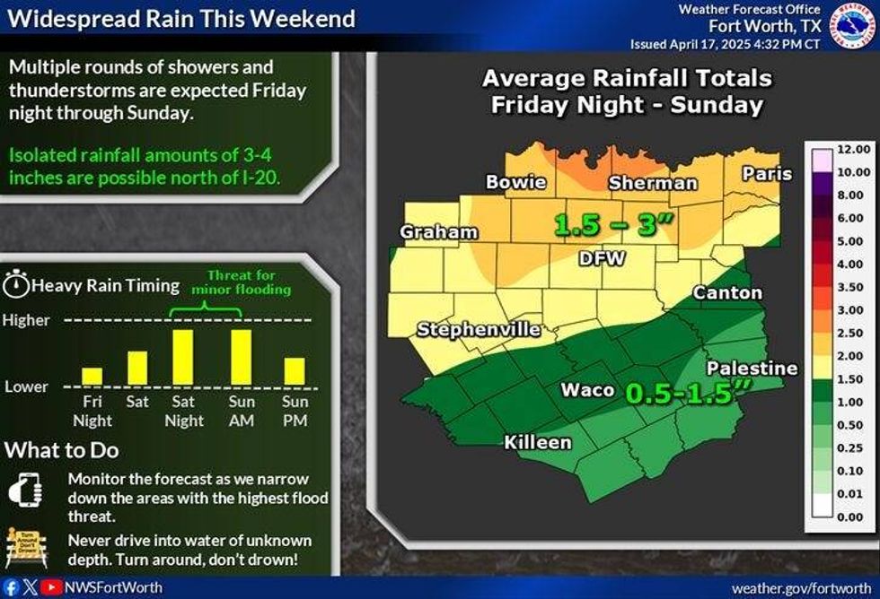
The entire system will pass through between 3 a.m. and 6 a.m. on Easter morning. After midnight, a significant line of showers and storms will develop just west of Wichita Falls, Abilene, stretching down to Del Rio. This line of storms will move rapidly through the early morning hours, containing small hail, damaging winds, and brief weak tornadoes. Everything should be east of Central Expressway and Interstate 45 by daybreak. General rainfall totals will be between 1-2 inches in DFW, with heavier totals northwest and lighter totals southeast.
 North Texas forecast for Sunday, April, 20, 2025.National Weather Service
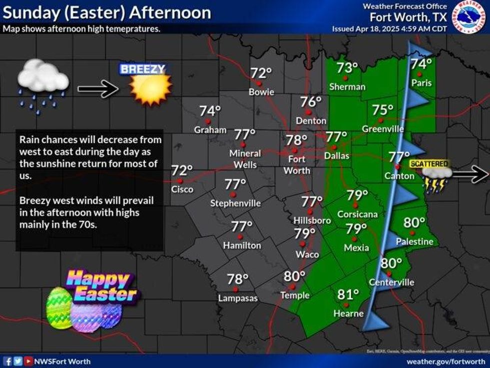
Clouds will struggle to clear until after the noon hour as dry air filters in from the west. High temperatures will reach the low to mid-70s. Sunday evening will be an excellent time to fire up the grill.
Monday will be the best day next week, with afternoon highs near 80 degrees and plenty of sunshine. After that, late Tuesday through Friday, on-and-off showers and storms, some potentially severe, will affect a significant portion of North Texas as an active weather pattern continues.
 North Texas rainfall totalsNational Weather Service
7-Day Headlines
DFW hit 84 degrees on Thursday.
Another warm day, and very windy.
Storms, some severe, Saturday to early Sunday.
Threats: Large hail, damaging wind, isolated tornadoes (northwest).
One to two inches of rain, heavier totals northwest.
Clearing Easter afternoon, turning cooler.
More storms late Tuesday - Friday
*Thursday Rain: 0.00"; Thursday High: 84 Low: 66
*Friday's Averages: High: 77; Low: 56
*Record high: 100 (1925): Record low: 36 (1901)
*April Rain: 1.31"; Deficit:
*2025 Rain: 10.02"; Deficit:
*Sunrise: 6:53am; Sunset: 8:02pm
Friday: Morning clouds, some afternoon sun. Warm and windy. High: Mid 80s. Wind: South 15-25. G30 mph.
Friday night: Increasing clouds, breezy and mild. Scattered showers and strong storms by daybreak. Low: Near 70. South 15-25 mph.
Saturday: Mostly cloudy and mild. Morning showers and storms, then scattered late afternoon and evening showers and storms. Some severe. High: Low 80s.
Sunday: Early morning showers and storms, some severe, then decreasing clouds after the noon hour. Breezy and comfortable. High: Low to mid 70s.
Monday: Mostly sunny and nice. High: Near 80.
Tuesday: Partly cloudy and warmer. Showers and storms return late, some severe. High: Mid 80s.
LISTEN on the Audacy App
Tell your Smart Speaker to "PLAY 1080 KRLD"
Sign Up to receive our KRLD Insider Newsletter for more news
Follow us on Facebook | Twitter | Instagram | YouTube