A pleasant start to the week is expected, but severe weather conditions are anticipated to escalate from Tuesday afternoon through early Wednesday. A notable cold front will bring cooler temperatures midweek, followed by a rapid warming trend leading into the spring break weekend.
Good morning, everyone. Hopefully, you had an enjoyable weekend and received some much-needed rainfall on Saturday. Conditions dried out, and Sunday turned out to be a spectacular day. Hopefully, you had the opportunity to enjoy the sunshine and perhaps even mowed your lawn for the first time this season.
Temperatures have returned to the 60s for morning commutes today, as the cold front that moved through over the weekend has lifted back to the north. Although low clouds will be present in the morning, some sunshine will reappear by late morning and especially in the afternoon, with highs reaching the low 80s. It will also be a windy day.
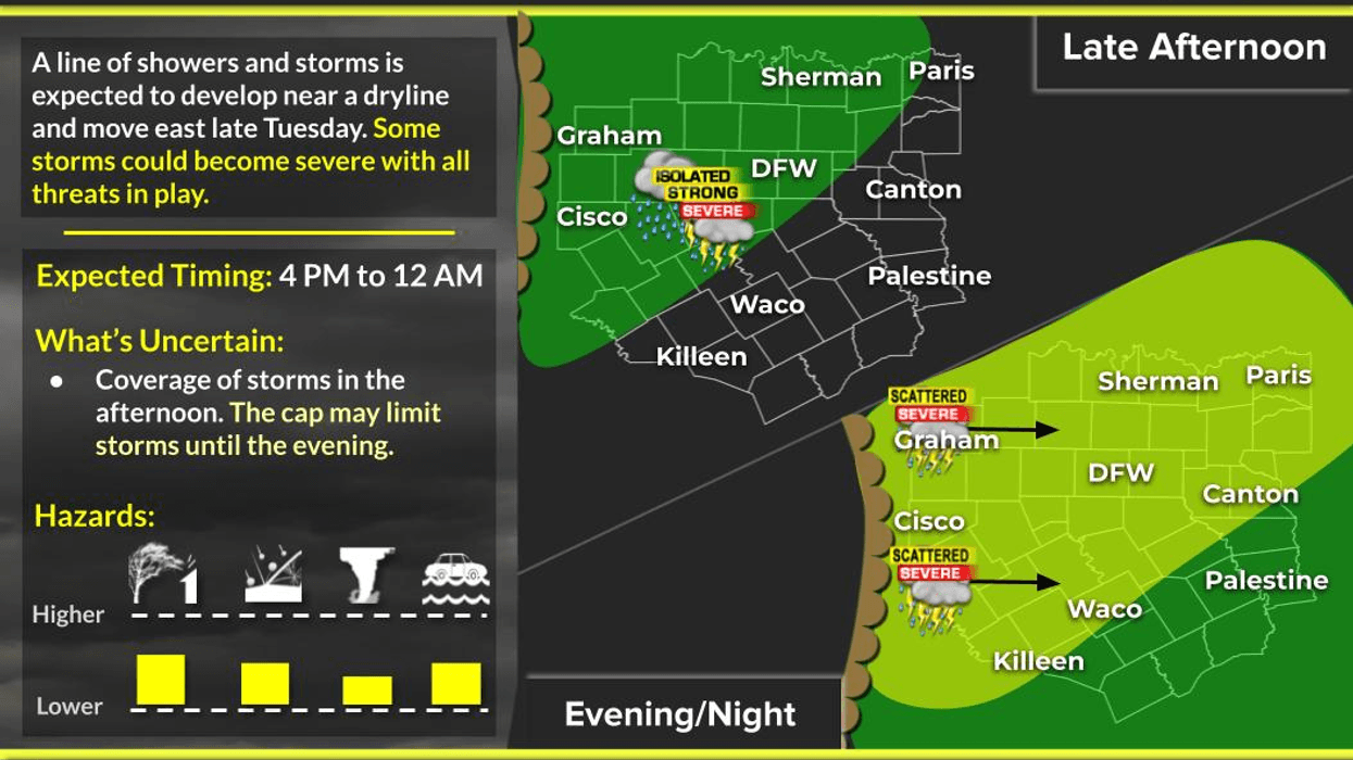
Tuesday is expected to become stormy, particularly in the late afternoon and evening, with a higher likelihood of severe thunderstorms in our northwestern counties. Some of these storms may approach the I-35 Corridor by early evening. Large hail, damaging winds, and isolated tornadoes are possible. Temperatures will warm up to the mid-80s across the region.
By late Tuesday evening, a line of showers and storms will develop approximately 250 miles west of us and rapidly move in our direction towards midnight. Smaller hail, damaging winds, and brief tornadoes are possible during this event, which will occur while you are asleep. Therefore, it is a good idea to sign up for my weather alert service, WeatherCall Nexgen at dantheweatherman.com, which will call you if severe weather impacts your area.
KRLD will also activate our storm center team coverage and provide live updates on the radio if conditions warrant. Please remember that layers can save lives.
A cold front will pass through the area on Wednesday, clearing out the skies and drying the air. Afternoon highs on Wednesday will only reach the low 70s early in the afternoon. Morning lows will drop to the 40s on Thursday, with plenty of sunshine and dry air expected in the afternoon. Afternoon highs will only reach the mid-60s, which is average for this time of year.
Temperatures will rapidly rise on Friday, with highs returning to the 70s, and by the weekend, we will be back in the 80s with plenty of sunshine and windy conditions. This will be ideal weather for spring breakers, especially along the Texas coast, where the weather will be phenomenal.
Have a great day today, stay weather-aware tomorrow into early Wednesday, and enjoy the weather when you can, it's the only weather you've got.
7-Day Headlines:
* DFW Airport reached 75 yesterday.
* Clouds and humidity are back.
* Back in the 80's today.
* Strong to severe storms return late tomorrow afternoon, mainly west
* Threats: Hail, wind, and isolated tornadoes.
* Line of strong and isolated severe storms early Wednesday morning.
* Beautiful weather Thursday – Sunday. No rain.
*Yest Rain: 0.00"; Yest High: 75; Low: 45
*Today's Averages: High: 66; Low: 46
*Record high: 100 (1911); Record low 20 (1996)
*March rain: 1.70"; Surplus: 0.80"
*2026 Rain: 3.94"; Snow: 2.4" Deficit:
*Sunrise: 7:45am; Sunset: 7:32pm
Monday: Mostly to partly cloudy, breezy and mild. High: Low to mid 80s. Wind: South 10-20 mph.
Monday night: Increasing low clouds. Low: Upper 60s. Wind: South 15-25 mph.
Tuesday: A few morning showers. Scattered late afternoon severe storms, mainly west and NW (large hail, wind and isolated tornado), a line of strong and severe storms late Tuesday into early Wednesday. Threats: Small hail, gusty wind, an isolated weak tornado. High: Upper 70s. Wind: South 15--25 mph.
Wednesday: Morning showers and storms move east. Decreasing clouds, windy and cooler by afternoon. High: Low 70s, falling into the 60s during the day.
Thursday: Sunny, less wind and PERFECT! High: Mid 60s.
Friday: Sunny, warmer, continued nice. High: Mid to upper 70s.
Weekend: Partly cloudy, windy and warmer. High: Low to mid 80s.
LISTEN on the Audacy App
Tell your Smart Speaker to "PLAY 1080 KRLD"
Sign Up to receive our KRLD Insider Newsletter for more news
Follow us on Facebook | Twitter | Instagram | YouTube