North Texas woke up to temperatures almost 20 degrees above average Monday morning, with readings mostly in the upper 50s to low 60s with plenty of cloud cover.
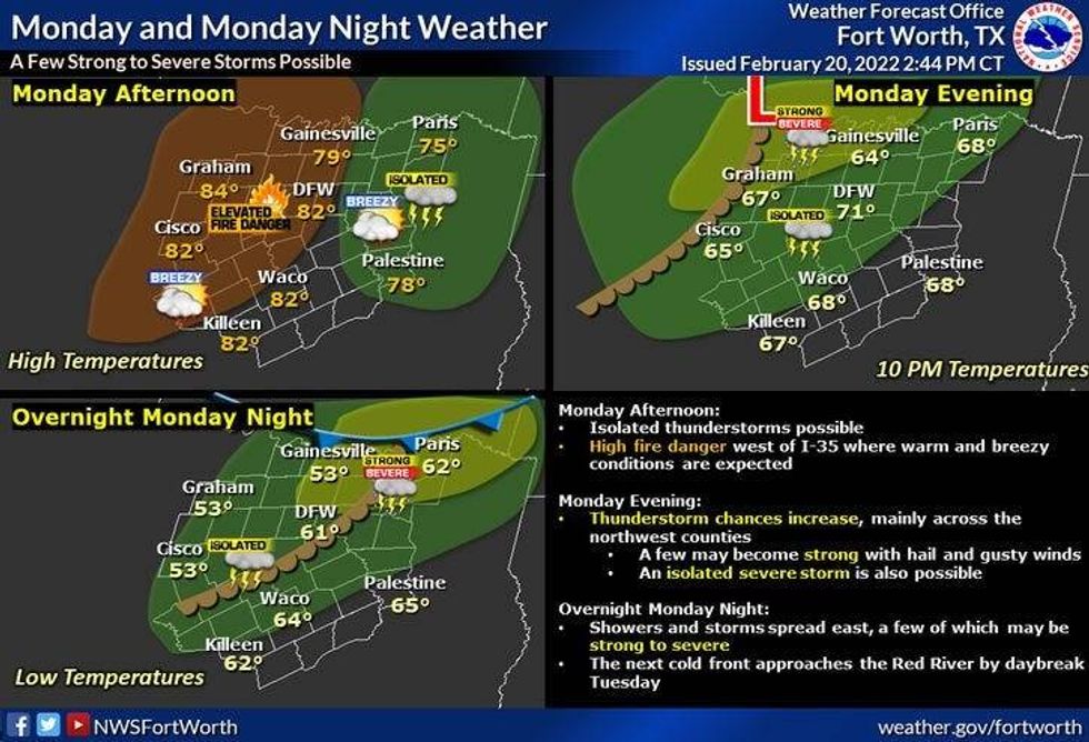
A beautiful day is ahead with more clouds and sun and afternoon highs between 75 and 80 degrees. It will be very windy as south winds blow as high as 30 mph. This creates another high grassfire danger, especially west of Interstate 35W
All will be eyes to our north and west Monday night, as some scattered strong to isolated severe storms may break out. Hail and wind will be the threats, but the immediate Dallas-Fort Worth area may escape the severe weather.
 Severe weather outlook for North Texas on Monday, Feb. 21, 2022.National Weather Service
Tuesday will be partly cloudy, breezy, and mild again, but the air will be a lot drier. Afternoon highs will creep into the low to mid-seventies before the Arctic boundary sags into the area by afternoon. Temperatures will tumble into the forties by Tuesday night, with a north wind gusting to 30 mph. Wind chills will be in the 30s.
Wednesday morning will be cold, windy and cloudy. Temperatures will be colder with readings hovering near freezing across DFW, and slightly colder north and west.
By Wednesday afternoon, precipitation will start to work in from the southwest, however, a lot of this will evaporate before it reaches the ground. Parts of North Texas could have some sleet pellets reaching the ground as early as Wednesday afternoon and evening. Roads should remain OK during this time frame.
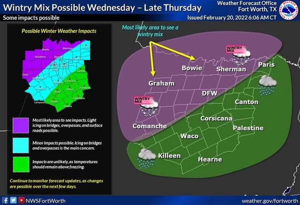 The National Weather Service shows a wintry mix is possible in North Texas on Wednesday into Thursday.National Weather Service
Wednesday night through Thursday afternoon needs to be watched closely. There's going be a sharp line between just a cold rain and freezing rain. I hesitate to draw the line right now, so I'll let the National Weather Service's graphic tell the story for now. Afternoon highs will hover between 28 and 32 degrees Wednesday night through Thursday.
As of now, it looks like the worst road conditions will be up towards the Red River and west of the Denton to Granbury line. If this cold air is deeper and seeps further south, all of the Dallas-Fort Worth area will encounter dangerous travel conditions Wednesday night through Friday noon, even though the precipitation will end from west to east Thursday afternoon.
Morning lows on Friday will drop into to low to mid-20s, so travel will be impacted once again. By Friday afternoon, sunshine will return, but it'll remain windy and cold. Highs will approach 40 degrees.
Another freeze is expected again Saturday morning with increasing clouds. Highs on Saturday will only be into the low forties, with a chance for a few sprinkles or even some sleet pellets may fall. We warm up Sunday into the mid to upper 50s!
Please continue to monitor the weather over the next 72 hours.
7-Day Headlines
* High yesterday: 68 degrees at DFW.
* Above average temp Monday and Tuesday.
* Sharply colder late Tuesday.
* Wintry mix Wednesday and Thursday.
* Dangerous travel, power outages.
* Warming this weekend.
_________________________________________________________
*Sunday Rain: 0.00"; *Sunday High: 68; Low: 39
*Monday's Averages: High: 62; Low: 42
*Record high: 95 (1996); Record low: 18 (1939)
_________________________________________________________
*February rain: 1.47"; February deficit:
*2022 Rain: 1.47"; 2022 deficit
*Sunrise: 7:04am; Sunset: 6:20pm
Monday: Mostly cloudy, windy and warm. High: Mid to upper 70s. Wind: South 15-25, G30 mph.
Monday night: Scattered strong storms. Best chance north of hwy 380, McKinney, Denton, Decatur. Low: Low to mid 60s. Wind: South 15-25, G30 mph.
Tuesday: Partly cloudy, turning windy and colder by afternoon. High: Near 70. Temps falling into the 40s by evening.
Wednesday and Thursday: Cloudy, windy and COLD. Wintry mix (freezing rain and sleet) and a cold rain possible. High: 28-32.
Friday: Partly cloudy, windy and cold. High: Near 40.
Saturday: Mostly cloudy, continued cold. Slight chance for light rain or light sleet. High: Low 40s.
Sunday: Sunny and warmer. High: Mid to upper 50s.
LISTEN on the Audacy App
Sign Up and Follow NewsRadio 1080 KRLD