Change is imminent, and our weather forecast indicates a significant shift over the coming days, extending through the middle of next week, with successive waves of showers and storms. Some of these storms may intensify into severe weather events.
Good morning and welcome to Tuesday. No jackets will be necessary this morning or for the foreseeable future, as above-average temperatures are expected to persist through the middle of next week.
This morning, temperatures are in the mid-60s, accompanied by extensive low clouds that have developed overnight, obscuring the total lunar eclipse for many of you. Breaks in the clouds are anticipated today, with afternoon highs reaching the low 80s, nearly 20 degrees above average for this time of year. It will also be quite windy, so please exercise caution while driving and secure any loose outdoor items.
Low clouds will return overnight, with a few isolated showers possible by daybreak tomorrow. Most areas will remain dry, with morning lows in the mid-60s, 20 degrees above average for this time of year.
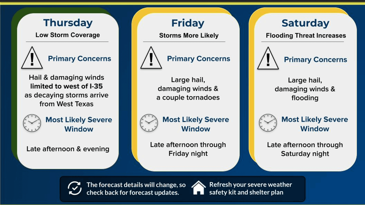
Wednesday presents our first opportunity for scattered strong to isolated severe storms. These storms will begin to develop along a weak frontal boundary, edging into the area by late afternoon and continuing into the evening. Areas along and east of Interstate 35W have the highest probability of storms, albeit at only 40%. Hail and wind will be the primary threats. Storm activity should subside before daybreak on Thursday.
Most of Thursday and Friday will be relatively dry, with only a few isolated showers and a slight chance of pop-up storms. Afternoon highs will return to near 80 degrees, accompanied by breezy conditions.
Our next significant weather system will arrive late Friday into early Saturday. All modes of severe weather are possible, especially in eastern Ok and KS.
By Saturday afternoon and evening, as a cold front moves into the area. Analyzing the latest data, this front appears to stall across North Texas, resulting in varying temperatures: the 60s north of the front and the 80s south of it. This front will also serve as a focal point for showers and storms to develop and move from southwest to northeast, producing areas of heavy rain across parts of North Texas. While it is still too early to determine the exact location of the heaviest rain, please remain weather-aware on Saturday and Sunday, as flooding may become a concern, particularly on Sunday afternoon and evening. Severe storms are expected to remain south of the frontal boundary.
Lingering storms are possible on Monday, depending on the front's position. Afternoon highs will return to the 70s.
Please ensure you have multiple ways to receive weather warnings and stay tuned to NewsRadio 1080 KRLD AM and this page for updates throughout the week and into the upcoming weekend. Enjoy your day!
7-Day Headlines:
* DFW Airport reached 81 yesterday.
* A windy and mild day today.
* Severe weather threat late Wednesday, Friday and Saturday.
* Threats: Hail, wind, and tornadoes.
* Flooding threat starts this weekend.
* 3.00" rain deficit will be erased.
*Yest Rain: 0.00"; Yest High: 81; Low: 60
*Today's Averages: High: 65; Low: 44
*Record high: 94 (1902); Record low 10 (1943)
*March rain: 0.00"; Deficit:
*2026 Rain: 2.24"; Snow: 2.4" Deficit:
*Sunrise: 6:52am; Sunset: 6:28pm
Tuesday: Morning clouds, afternoon sun. Windy and mild. High: Low 80s. Wind: South 15-25, G30 mph.
Tuesday night: Increasing clouds. A few showers by daybreak. Wind: South 10-20 mph.
Wednesday: Morning clouds, some afternoon sun. Scattered showers and storms, a few may become severe by late afternoon and evening. Threats: Hail and wind. High: Near 80. Wind: South 10-20 mph.
Thursday: Morning showers, then partly cloudy, breezy and mild. High: Upper 70s.
Friday: Mostly to partly cloudy, breezy and warm. Scattered showers and storms, some severe by evening. Threats: Hail, wind, an isolated tornado. High: Near 80.
Weekend: Mostly cloudy and a bit cooler. Waves of heavy rain. Some may be severe on Saturday. Highs: 70s to 60s.
Monday: Mostly cloudy, breezy and warmer. Isolated showers and storms. High: Near 80.
LISTEN on the Audacy App
Tell your Smart Speaker to "PLAY 1080 KRLD"
Sign Up to receive our KRLD Insider Newsletter for more news
Follow us on Facebook | Twitter | Instagram | YouTube