


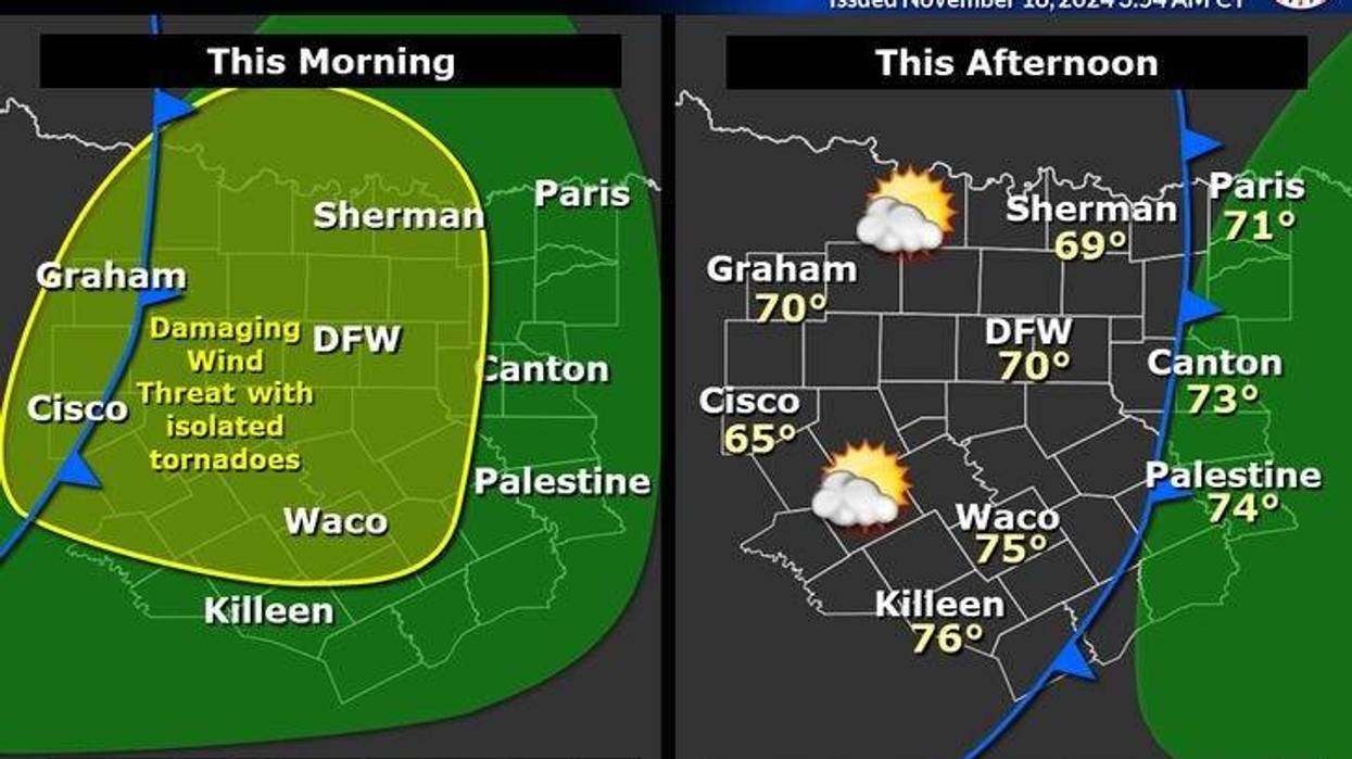
A large area of thunderstorms will work their way across North Texas through late Monday morning. One or two could become severe, but it's doubtful. Wind gusts to 40 mph along with 1-2 inches of rain are possible in localized areas.
The tornado threat is very low but not zero. Temperatures will be in the low 70s and the air is thick as a brick!
The humid air mass will rapidly dry out Monday afternoon as a Pacific front moves through the area. Winds will gust to 40 mph, but temperatures will hold steady in the low 70s. The wind will relax a little bit overnight as temperatures drop into the 50s.
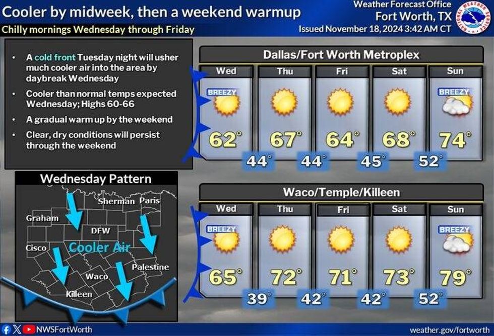
Tuesday looks fantastic. There will be plenty of sunshine, and light wind with highs back in the low 70s. By Tuesday night, a strong Canadian front will move through the area dropping temperatures into the upper 30s to mid 40s by Wednesday morning. Sunny, breezy, and cool for Wednesday with afternoon highs and the low 60s.
Things cool back into the 30s and 40s on Thursday morning with highs in the mid-60s. Similar weather for Friday as well, but just a few degrees cooler. Highs will only reach the low 60s with plenty of sunshine.
The weekend looks nice! Sunny upper 60s for Saturday. Plenty of sunshine, very windy with highs in the mid 70s on Sunday.
 North Texas forecastNational Weather Service
7-Day Headlines
DFW reached 79 degrees on Sunday.
A strong line of storms Monday morning.
Threats: Damaging wind, an isolated tornado.
Very windy Monday afternoon. Gusts to 40mph.
West Texas dust on your windshields Tuesday morning.
Strong Tuesday evening cold front.
Lows: 30s and 40s; Highs in the 60s through week's end.
Awesome weekend ahead.
*Sunday Rain: 0.06"; Sunday High: 79 Low: 64
*Monday's Averages: High: 66; Low: 45
*Record high: 83 (1973): Record low: 20 (1973)
_______________________________________________________
*November rain: 1.46"; Deficit: ."
*2024 Rain: 35.61"; Surplus: 2.39"
*Sunrise: 7:03am; Sunset: 5:24pm
________________________________________________________
Monday: Morning showers and storms. Isolated severe for damaging wind and an isolated tornado. Becoming sunny, VERY windy, and mild. High: Low 70s. Wind: WSW 20-30, G40 mph.
Monday night: Clear and cool. Low: 45-55. Wind: SW 10-15 mph.
Tuesday: Sunny and mild. Evening strong DRY cold front. High: Low 70s. Wind: NW 5-10 mph.
Wednesday: Sunny, windy, and cooler. High: Low 60s.
Thursday: Sunny, remaining cool. High: Mid 60s.
Friday. Weak morning cold front. Sunny, remaining cool. High: Low 60s.
Saturday: Passing high clouds and seasonable. High: Upper 60s.
Sunday: Mostly sunny, breezy and mild. High: Mid-70s.
LISTEN on the Audacy App
Tell your Smart Speaker to "PLAY 1080 KRLD"
Sign Up to receive our KRLD Insider Newsletter for more news
Follow us on Facebook | Twitter | Instagram | YouTube


