North Texas will see seasonal weather through most of the weekend but turn sharply colder on Sunday with a cold week ahead. The question is, will we see any wintry precipitation by next Wednesday and Thursday?
It was a chilly start Thursday morning as readings fell into the 30s across all of North Texas. Wind is light and skies are clear. Sunny and beautiful with highs near 60 degrees.
Temperatures will drop into the 40s overnight, with more sunshine Friday. Highs will warm into the low 60s.
A warm front cruises through on Saturday morning and it could bring a few scattered showers. Temperatures will start in the 40s on Saturday and reach 60 degrees with a mostly cloudy sky during the day.
The strongest cold front of the early winter season arrives on Sunday. There could be a few scattered showers as the front comes through, but better chances will be in East Texas. Temperatures will reach the low 60s by 12 p.m. Sunday and then quickly fall through the 40s during the day with a north wind gusting to 35 mph. Temperatures will continue to fall overnight into Monday morning, down into the mid to upper 20s.
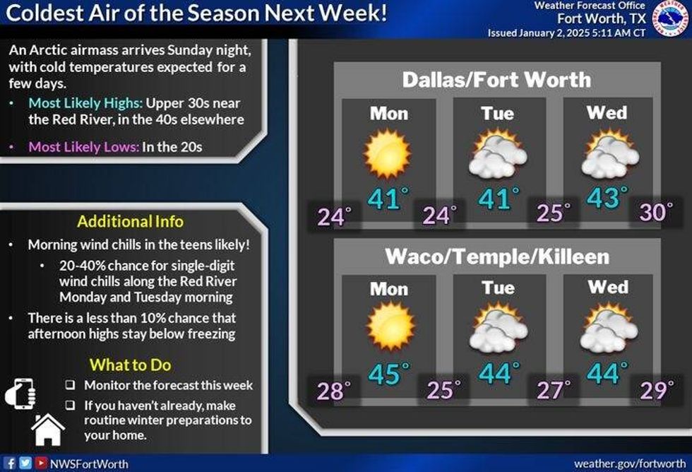
A chilly week will follow. Temperatures will struggle to hit 40 degrees with sunshine on Monday.
Clouds will increase on Tuesday and especially Wednesday, with morning lows in the 20s and afternoon highs near 40 degrees. On Wednesday, there will be increasing clouds with highs in the upper 30s.
There will be some light snow flurries trying to move in from the northwest on Tuesday, but they will most likely evaporate before they reach North Texas.
The next weathermaker will move in from the west late Wednesday and Thursday. It's still too early to tell where the storm will track, how strong it will be as well and how quickly it will move across Texas. It could bring the possibility of some wintry precipitation across parts of the state.
 Temperatures early next week in North Texas.National Weather Service
7-Day Headlines
* DFW Airport reached 50 on Wednesday.
* Pleasant weather through Saturday.
* A few showers early Saturday and Sunday.
* An Arctic blast arrives by Sunday afternoon.
* Temperatures in the 20s Monday morning.
* WInterize your homes and vehicles.
* Watching for wintry precipitation late Wednesday and Thursday.
_____________________________________________________
*Wednesday Rain: 0.00"; Wednesday High: 50; Low: 36
*Thursday's Averages: High: 56; Low: 36
*Record high: 78 (2004, 2023); Record low: 8 (1911)
________________________________________________________
*January Rain: 0.00"; Deficit:
*2025 Rain: 0.00"; Deficit:
*Sunrise: 7:31am; Sunset: 5:34pm
________________________________________________________
Thursday: Sunny and cool. High: Near 60. South 5-10 mph.
Thursday night: Clear and chilly. Low: Low to mid-40s. Variable 5-10 mph.
Friday: Mostly sunny and cool. High: Low 60s. Wind: East 5 mph.
Saturday: AM showers, then mostly cloudy and cool. High: Near 60.
Sunday: Morning showers, then mostly clear, turn windy and MUCH colder in the afternoon. High: Low 60s early, falling through the 40s by dinnertime.
Monday: Mostly sunny, windy, and cold. High: Near 40.
Tuesday: Partly to mostly cloudy and cold. A few snow flurries NW of DFW. Low: 20s; High: Near 40.
Wednesday: Increasing clouds and cold. High: Mid to upper 30s.
LISTEN on the Audacy App
Tell your Smart Speaker to "PLAY 1080 KRLD"
Sign Up to receive our KRLD Insider Newsletter for more news
Follow us on Facebook | Twitter | Instagram | YouTube