Good morning, everyone, and welcome to Monday!
We're now entering our second full week of summer, and it's going to feel like it all week long, stretching right into the holiday weekend.
One thing a little different this week: Saharan dust will be drifting through the upper atmosphere, at least through Thursday, making for some colorful sunrises and sunsets.
This is also the time of year when I start searching for different ways to say the word hot. Scorching, stifling, blistering, sizzling...you get the idea! I have to get creative this time of year to keep my followers entertained.
The heat will be very dangerous this week, so please stay hydrated and take frequent breaks if you're working outdoors. Check on the elderly, make sure pets have a cool place to escape the afternoon heat, and always remember to Beat the Heat—Check the Back Seat for children and pets before leaving your vehicle.
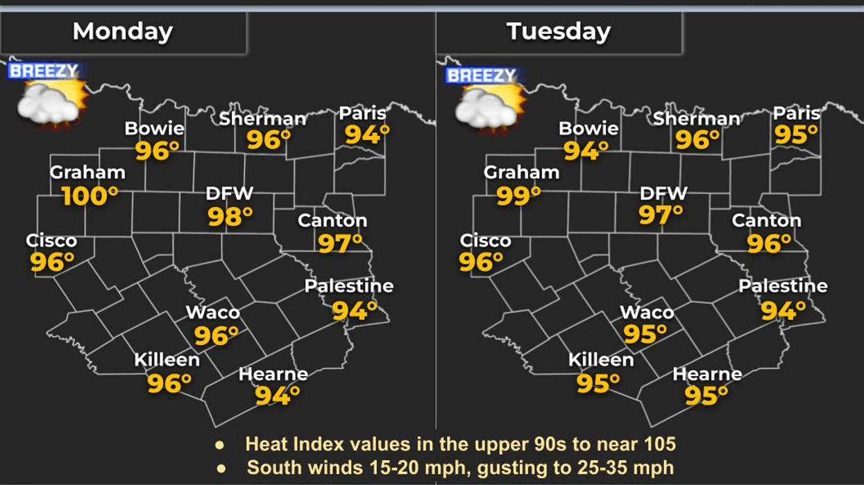
The upper-level ridge of high pressure that was over us late last week has shifted into the eastern half of the United States. As a result, numerous Heat Advisories and Excessive Heat Warnings stretch from Minneapolis all the way to Orlando, Florida. Heat index values in some areas will approach or even exceed 110°.
Here in Texas, we're accustomed to this kind of heat, but many of our friends farther north aren't. Many homes there don't have central air conditioning, and some rely on a single window unit running for hours just to cool one bedroom. If you have friends or family in those areas, be sure to check on them.
The ridge will remain close enough to North Texas to keep temperatures running about 4 degrees above normal through the end of the week. Afternoon highs will climb into the upper 90s, with heat index values reaching around 104°, just below our local Heat Advisory criteria.
As I mentioned above, Saharan dust will be floating more than 20,000 feet overhead, which should provide some beautiful sunrises and sunsets over the next few days.
I'm also keeping an eye on an easterly wave moving westward across the Gulf Coast late this week. It may get close enough Thursday and Friday to bring a few late-day showers and thunderstorms to our friends in East Texas.
Could a few showers or storms sneak into parts of North Texas on the Fourth of July or Sunday? Sure, it's possible. However, the chances are looking a bit slimmer than they did a couple of days ago. Since we're talking about Days 6 and 7 of the forecast, things can certainly change.
For now, I don't see any widespread weather issues that would hamper outdoor plans or cancel fireworks displays during the early to mid-evening hours. Of course, I'll continue keeping a close eye on the forecast and let you know if anything changes.
In the meantime, stay cool, stay hydrated, and enjoy the weather when you can...it's the only weather you've got!
7-Day Headlines:- * DFW Airport reached 97 on Wednesday
- * No Heat Advisories for now today
- * Flirting with 100 degrees through 4th of July weekend
- * Isolated late afternoon showers and storms Thursday – Saturday east of DFW afternoon and evening
- * Isolated afternoon and evening showers and storms Sunday
- * Please download our Audacy app. Listen to NewsRadio 1080am live anytime/anywhere
Almanac:
- *Yest Rain: 0.00”; Yest High: 97; Low: 79
- *Today’s Averages: High: 94; Low: 74
- *Record high: 108 (1980); Record low 62 (1985)
- *June rain: 8.07”; Surplus: 4.58”
- *2026 Rain: 21.25”; Snow: 2.4” Surplus: 1.17”
- *Sunrise: 6.23am; Sunset: 8:41pm
Forecast:
Monday: Morning clouds, afternoon sun. Hot, dusty and windy. High: Mid to upper 90s. Heat index: Near 104. Wind: South 15-25, G30 mph.
Monday night: Increasing clouds by daybreak. Breezy, mild and muggy. Low: Upper 70s. Wind: South 10-20 mph.
Tuesday: Morning clouds, afternoon sun. Hot, dusty and breezy. High: Mid to upper 90s. Heat index: Near 104. Wind: South 15-25 mph.
Wednesday: Morning clouds, afternoon sun. Breezy, dusty and hot. High: Mid to upper 90s. Heat index: Near 104.
Thursday and Friday: Partly cloudy, hot and hazy. Less wind. Isolated late day shows and storms EAST of DFW. High: Upper 90s. Heat index: Near 104.
4th of July: Partly cloudy, hot and hazy. Isolated late day storms EAST of DFW.
Sunday: Partly cloudy and hot. Isolated late day showers and storms. High: Upper 90s. Heat index: near 104.
LISTEN on the Audacy App
Tell your Smart Speaker to "PLAY 1080 KRLD"
Sign Up to receive our KRLD Insider Newsletter for more news
Follow us on Facebook | Twitter | Instagram | YouTube