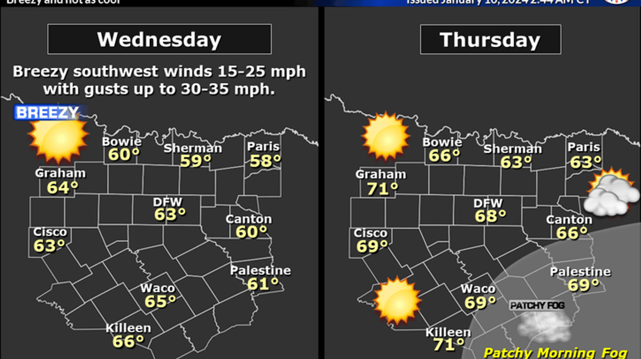
We've got seasonable temperatures this Wednesday morning, as readings have fallen into the low to mid-30s. It will be sunny, windy, and warmer today with highs and the low to mid-60s. A S-SW wind will gust to 35 mph.
Not as cold tonight under a clear sky. Temperatures will fall into the low to mid-40s.
Thursday looks equally as nice and even warmer! Sunny and 70.
 National Weather Service - Fort Worth
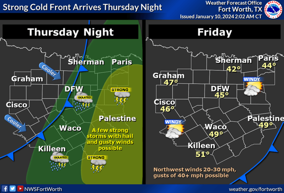
A strong cold front will blow through the area before you wake up on Friday. There is a chance for a few scattered showers and storms along the front. The greatest coverage will be in east Texas for the first half of the day. You'll wake up to temperatures near freezing on Friday morning with wind chills in the teens. We'll struggle to get above 45° by afternoon, with a north wind gusting to 45 mph.
Saturday looks decent with plenty of sunshine. Afternoon highs will reach the low to mid 50s. Typical for mid January.
 National Weather Service - Fort Worth
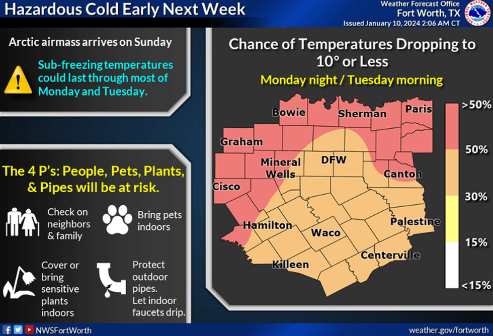
By late Saturday night into noon Sunday, an Arctic blast will plow through the area. The high temperature on Sunday will be during the morning hours. Some areas may jump up to 50° but it's doubtful. Northwest winds will gust to 40 miles per hour and temperatures will fall into the teens by Sunday evening. Wind chills will be near zero.
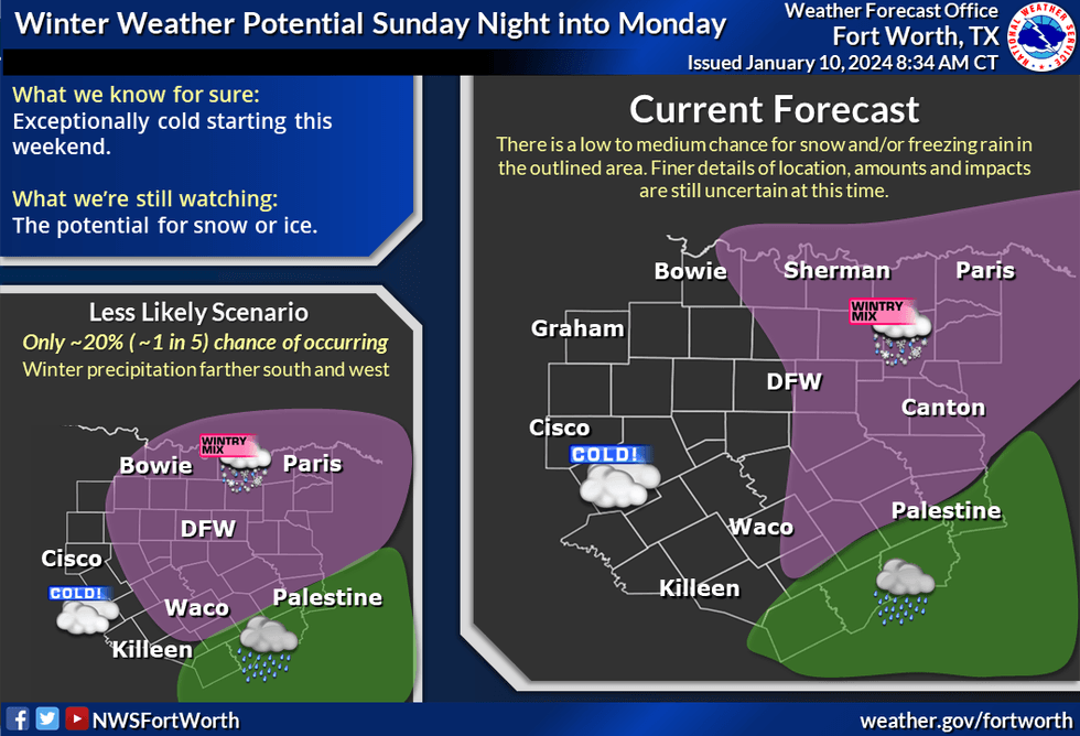
To make matters worse, an upper-level disturbance will be crossing the area late Sunday into Monday bringing a slight chance of a wintry mix across the area. The best chances will be east of the Dallas-Fort Worth area and anything that falls will stick. We will have a few days to monitor the data as we get closer to Sunday.
 National Weather Serrvice - Fort Worth
Near record-breaking low temperatures in the morning hours on Monday and Tuesday as readings fall into the teens. There could even be some single digits in the forecast north of DFW. Afternoon highs on Monday will only warm into the low to mid-20s. Upper 20s on Tuesday. We'll finally get above freezing by Wednesday.
Please keep in mind this wintery mix is not in stone. The storm system hasn't come ashore in the Pacific Northwest yet. Data may change as we work our way through the next 72 to 84 hours so stay tuned.
*Yest Rain: 0.00"; Yest High: 607 Low: 35
*Today's Averages: High: 56; Low: 36
*Record high: 83 (2023); Record low: 7 (1982)
*January rain: 1.31"; Surplus: 0.52"
*2024 Rain: 1.31"; Surplus: 0.52"
*Sunrise: 7:32am; Sunset: 5:40pm
Tonight: Clear, not as windy and cold. Low: Low to mid 40s. Wind: Lt. Variable.
Thursday: Sunny, breezy and warmer. High: Near 70. Wind: South 15-25 mph.
Friday: Morning showers and storms, mainly east of DFW, turning windy and MUCH colder early. High: 12:01 am: 57; 6 am: 28; 4 pm: 44. Wind: NW 25-35, G50.
Saturday: Sunny and cool. Increasing clouds late. Arctic cold front before midnight. Turning windy and SHARPLY colder High: Low to mid 50s.
Sunday: Cloudy, windy, and VERY cold. Low: 15-20 (wind chills in the single digits); High: Low 20s. Watching out for wintry precip by afternoon and especially the evening. FZRA to mainly SLEET to some SNOW (east of I-35W). Chance at 30% right now, this may go up.
Monday - MLK Day: Cloudy to partly cloudy late, windy, and VERY cold. Watching out for a wintry mix through noon. Chance at 30%, higher chances in the afternoon in east Texas right now. Low: 12-17; (wind chills below zero); High: Low 20s.
Tuesday: Sunny and continued cold. Less wind. Low: 5-12; High: Mid to upper 20s.
LISTEN on the Audacy App
Tell your Smart Speaker to "PLAY 1080 KRLD"
Sign Up to receive our KRLD Insider Newsletter for more news
Follow us on Facebook | Twitter | Instagram | YouTube