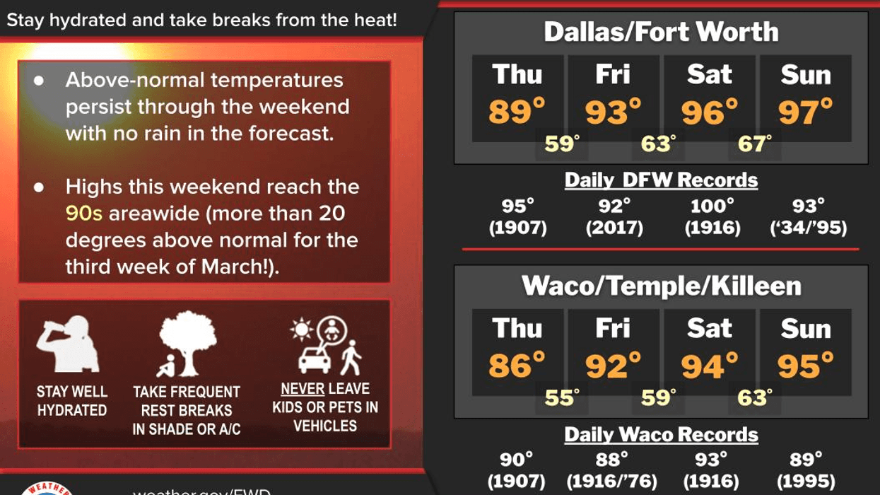
Spring starts a little bit before 10:00 this morning, but it'll feel more like summer this weekend. Plus, no rain for the foreseeable future with plenty of sunshine and above-average temperatures for at least the next 7 days.
Good morning and welcome to Friday! Hope everyone's had a great week so far and enjoyed spring break. Unseasonably warm weather will continue for the next 7 days with near record-breaking heat today and Sunday.
We're waking up to temperatures in the upper 50s to low 60s at this hour. Jackets may be necessary for some but probably not for others. The record high for today is 92°. We may come close to tying that record this afternoon. Also, spring arrives a little bit before 10:00 this morning! Enjoy!
The weekend will be fantastically hot! Morning lows will be in the 60s with afternoon highs in the middle 90s Saturday and mid to upper 90s on Sunday. The record high for Saturday is 100°. We won't break that. However, we will break a record on Sunday with highs again in the mid to upper 90s. The record high for Sunday is 93°.
A cold front will work its way through the area late Sunday night, dropping temperatures into the upper 70s for highs on Monday. Please keep in mind, the average high on Monday is up to 71°. We're still above average for this time of the year. Unfortunately, no rain is forecast for along the front.
The cold front will lift back north Tuesday morning and temperatures will be on the rise again. Afternoon highs will reach the mid to upper 80s with plenty of sunshine. The warming trend continues Wednesday and Thursday with ample sunshine. Afternoon highs both days will reach the low 90s. That's over 20° above average for this time of the year.
Our next cold front arrives by the end of next week but it's too early to tell if any rain will accompany it. Stay tuned.
Have a great day today, a terrific weekend and enjoy the weather when you can, it's the only weather you've got!
7-Day Headlines:
* DFW Airport reached 86 yesterday.
* Spring arrives at 9:46am this morning!
* Record breaking heat on the way.
* PERFECT weather for outdoor activities.
* Stay hydrated; Beat the heat, check your back seat.
* No rain for at least 10 days!
* Weak/dry cold front early Monday.
*Yest Rain: 000"; Yest High: 86; Low: 53
*Today's Averages: High: 70; Low: 49
*Record high: 92 (2017); Record low 19 (1965)
*March rain: 2.91"; Surplus: 0.88"
*2026 Rain: 5.15"; Snow: 2.4" Deficit:
*Sunrise: 7:30am; Sunset: 7:41pm
Friday: FIRST DAY OF SPRING (9:46am). Sunny, breezy and warm! High: Low 90s (Record is 92). Wind: SSW 10-15 mph.
Friday night: Clear and mild. Low: Low to mid 60s. Wind: SSW 5-10 mph.
Saturday: Sunny and VERY warm. High: Low to mid 90s (Record is 100). Wind: SSW 5-10 mph.
Sunday: Sunny and breezy, with record breaking heat! High: Mid to upper 90s (Record is 94). Late-late evening cold front.
Monday: Sunny, breezy and a tad cooler. High: Upper 70s.
Tuesday: Sunny and warmer. South winds return. High: Mid to upper 80s.
Wednesday: Sunny and VERY Warm. High: Near 90.
Thursday: High clouds and warm again. High: Low to mid 90s.
LISTEN on the Audacy App
Tell your Smart Speaker to "PLAY 1080 KRLD"
Sign Up to receive our KRLD Insider Newsletter for more news
Follow us on Facebook | Twitter | Instagram | YouTube