We're waking up the temperatures in the low to mid 40s with some cloud cover overhead. Clouds will continue to increase through mid afternoon with a slight chance of showers working the way in from the northwest after lunchtime. Precipitation totals will be very light. Afternoon highs will struggle to hit 60゚ again. Wind will slowly shift to the south by this evening.
Some clouds will pass overhead tonight as temperatures drop back into the load of mid forties. I would go ahead and bring your plants indoor once again.
 National Weather Service - Fort Worth
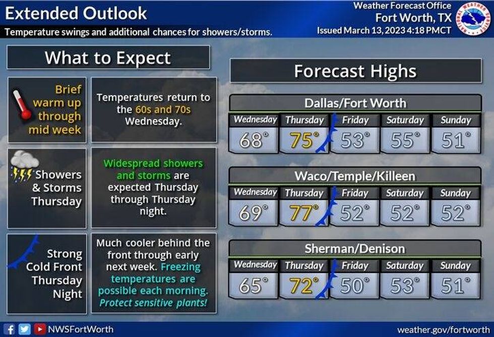
Our slow warm up starts tomorrow with afternoon highs in the upper sixties, but it'll be very windy. Southerly winds return and gust to 30 mph.
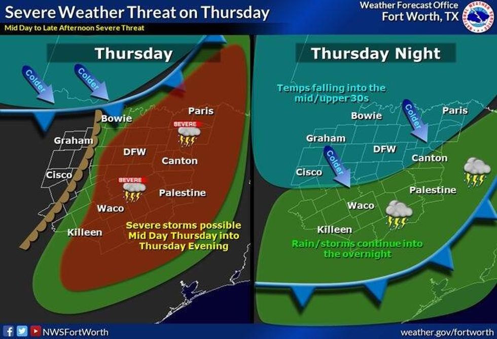
And then, all eyes on Thursday's weather. By early afternoon, the dryline surges in from West Texas and a strong cold front approaches from the NW. Right now we have a level 2 out of 5 for all modes of severe weather. Hail, wind and isolated tornadoes. I will continue to monitor and update you over the next couple of days. Afternoon highs may reach 80゚ in some areas.
 National Weather Service - Fort Worth
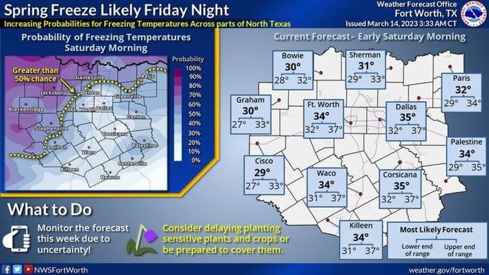
A strong cold front will then plow through here Thursday night. You'll wake up to temperatures in the upper thirties by Friday morning. There may even be a few chilly rain showers, possibly mixing in with a little wet snow just west of DFW during the morning hours. No accumulations are expected. Skies will slowly decrease by afternoon with afternoon highs struggling to get above 50゚. Northwest wind will gust to 40 mph the 1st half of the day.
 National Weather Service - Fort Worth
The weekend looks sunny, but chilly. Afternoon highs will reach the mid fifties on Saturday, low fifties on Sunday with increasing clouds. There might even be a few showers around by Sunday evening. More showers are in the forecast for Monday with afternoon highs only in the upper forties. It's still winter.
*Yest Rain: 0.00"; Yest High: 60; Low: 46
*Today's Averages: High: 68; Low: 46
*Record high: 92 (1989); Record low: 26 (1988)
*March Rain: 1.35"; Deficit: 0.07"
*2023 Rain: 6.70"; Deficit: 0.07"
*Sunrise: 7:39am; Sunset: 7:36pm
Today: Increasing clouds and cool. A few rain showers this afternoon. High: Upper 50s. Wind: Variable 5-15 mph.
Tonight: Partly cloudy and chilly. Low: Low to mid 40s. Wind: SE 5-10 mph.
Tomorrow: Partly cloudy and a bit warmer. Windy as well. Wind: South 10-20, G30 mph.
Thursday: Mostly cloudy, very windy and mild. Scattered showers and storms by afternoon, ending by early evening. Some severe (level 2 out of 5) Threats: Hail, wind and isolated tornadoes. High: Near 80.
St. Patrick's Day: Morning showers, mixing with snow west? Decreasing clouds by afternoon. Windy and MUCH cooler. High: Low 50s.
Saturday: Morning freeze away from DFW. Partly cloudy and cool. High: Mid 50s.
Sunday: Increasing clouds, continued chilly. Chance of a chilly rain late. High: Low 50s.
Monday: Cloudy and chilly. Chance of rain. High: Upper 40s.
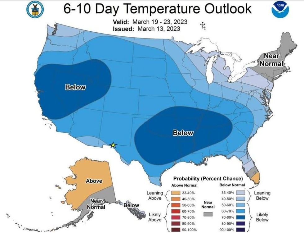
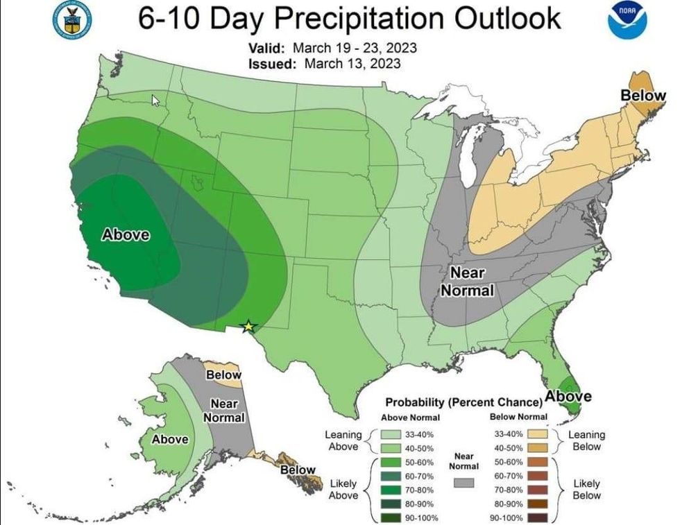
As I stated before, winter is not going away anytime soon… these are the temperature and precipitation trends the next 6 to 10 days.
 NOAA
NOAA
We have rain in the forecast Thursday and then again late Sunday into early next week. The warmest day will be Thursday near 80, every other day will be below average.
 NOAA
NOAA

LISTEN on the Audacy App
Tell your Smart Speaker to "PLAY 1080 KRLD"
Sign Up to receive our KRLD Insider Newsletter for more news