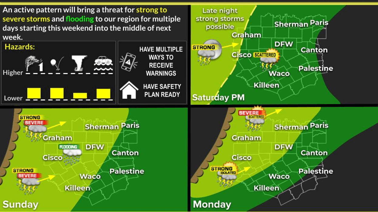
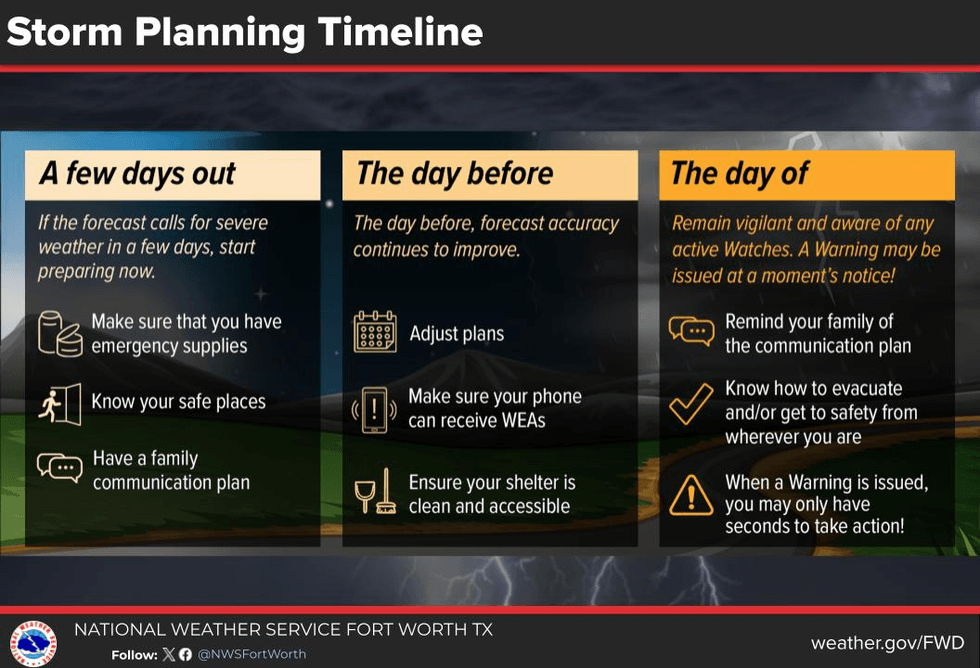
Severe thunderstorms are back in my 7-day forecast. Please keep in mind that not everyone will see severe weather over the coming days but some will. Please have multiple ways to receive warnings! I'll do my best below to hone in on the timing for severe storms over the coming days.
Good morning my friends and happy almost Friday! Things are quiet on the homefront this morning as temperatures are a little warmer than we've been experiencing over the past several mornings. Most of us have fallen into the low 60s at this hour under a partly cloudy sky. Ample sunshine today with afternoon highs approaching 80°. South wind will pick up at 10 to 20 miles per hour.
Friday is a bit tricky. We'll wake up to some morning clouds and temperatures in the low 60s. There will be a bunch of rain forming across South Texas when you wake up. This area of rain will be shooting North through the day and evening. I think some of these showers and isolated storms will survive their trek northbound, but they can significantly weaken by tomorrow late evening as they move into North Texas. These storms will not be severe.
Your weekend forecast looks a bit stormy, especially into Sunday. Afternoon highs will reach 80° with morning lows in the 60s once again. Showers and storms will develop west of North Texas late Saturday afternoon. These will try to work their way into North Texas by late Saturday evening but the majority of the severe weather will shoot up into Oklahoma.
The dryline that formed Saturday's storm west of us will inch a little bit closer on Sunday afternoon. Showers and storms will break out along this boundary and affect our area towards evening. Some of these storms will become severe with all modes of severe weather possible.
Isolated severe storms are possible late Monday but better chances for severe storms move into the area on Tuesday and Wednesday, mainly during the late afternoon and evening hours. A severe weather event is possible once again. Please keep in mind that not everyone will see severe weather over the next seven days, but I encourage everyone to stay weather aware and keep it tuned to NewsRadio 1080 KRLD AM and right here on my Facebook page for updates through the weekend.
Have a great day today and please enjoy the weather when you can, it's the only weather you've got!
7-Day Headlines:
- DFW Airport reached 78 on Wednesday.
- Highs near 80 degrees through the middle of next week.
- Gulf moisture returns. South winds increase.
- Storm chances increase late Saturday - Wednesday.
- Some storms MAY become severe.
- All modes of severe weather are possible.
Almanac:
- Yest Rain: 0.00”; Yest High: 78; Low: 58
- Today’s Averages: High: 75; Low: 54
- Record high: 97 (1963); Record low 30 (1914)
- April rain: 2.59”; Surplus: 1.81”
- 2026 Rain: 7.75”; Snow: 2.4” Deficit: <1.62”>
- Sunrise: 7:04am; Sunset: 7:55pm
Forecast:
Thursday: Partly cloudy, breezy and warm. High: Near 80. Wind: SE 10-20 mph.
Thursday night: Partly to mostly cloudy, breezy and mild. Low: Low to mid 60s. Wind: SE 10-15 mph.
Friday: Partly cloudy, breezy and warm. A few showers and storms late in the day. Highest coverage south of DFW. High: Near 80. Wind: South 5-10 mph.
Saturday: Mostly to partly cloudy, breezy and warm. Scattered showers and storms late. Highest coverage west and NW of DFW. High: Near 80.
Sunday: Mostly cloudy, breezy and warm. Morning showers and isolated storms. Scattered strong to severe thunderstorms by evening. High: Near 80.
Monday - Wednesday: Partly cloudy, breezy and warm. Scattered showers and storms. Some severe. High: Near 80.
LISTEN on the Audacy App
Tell your Smart Speaker to "PLAY 1080 KRLD"
Sign Up to receive our KRLD Insider Newsletter for more news
Follow us on Facebook | Twitter | Instagram | YouTube