



Well, the warmer-than-average temperatures are going away this week! We'll be getting back closer to seasonal averages, with cool mornings, mild to pleasant afternoons, and much lower humidity.
First, we have to get through tonight's weather event and the early morning hours tomorrow. A significant weather change is on the way.
Winds will gust over 35 mph today out of the southeast, bringing plenty of moisture back into the area. Combine that with temperatures climbing into the mid-to-upper 80s and an approaching cold front, and we have the ingredients needed for showers and thunderstorms.
We'll actually have two fronts moving through. A Pacific front will arrive first, followed by a stronger cold front.
Storm development should begin around 5 or 6 this evening along and near Highway 277. During the late afternoon and evening hours, storms will develop and backbuild southwestward toward the Del Rio area before organizing into a line.
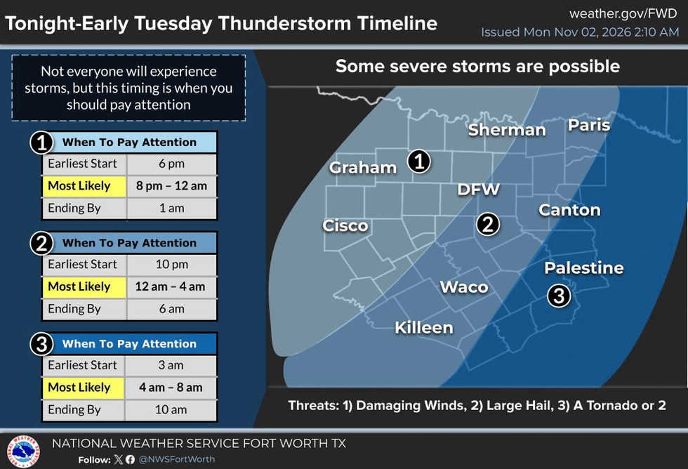
That line will eventually move into North Texas late this evening and continue through the early morning hours. The Dallas-Fort Worth area should see the storms before midnight, with the line pushing east of us overnight.
There is a chance for some strong to severe storms, including damaging wind gusts, large hail, and even an isolated tornado. The greatest concern for North Texas will be between approximately 10 p.m. and 3 a.m.
Once the front moves through, winds will shift to the north, bringing in much cooler and drier air. Skies will rapidly clear, and temperatures will drop into the mid-to-upper 50s for your commute tomorrow morning.
Tomorrow will be noticeably cooler and windy, with afternoon highs only reaching the low 70s.
Wednesday - Sunday mornings will be chilly, with temperatures dropping into the upper 40s to mid 50s.Afternoon highs through Sunday will warm into the 70s.
Another cold front will slide through North Texas late in the week, reinforcing the dry air already in place. Unfortunately, there won't be much moisture to work with, so rainfall chances will remain limited. There is a slight chance of rain Thursday, but it's not looking particularly promising.
The good news? Once we get past tonight's storms and gusty winds, we're looking at some absolutely beautiful weather across North Texas!
Have a great day, everyone! Thanks for following my page. Please like and share this forecast to help people across North Texas stay weather aware.
Have a blessed day!
7-Day Headlines:
- DFW Airport hit 79 degrees on Sunday
- Weather aware between 9pm Monday and 3am Tuesday
- ThreatsL Damaging wind, small hail and an isolated tornado
- Average rain totals: Less than an inch
- No more rain for a while after tonight
- Much cooler, lowering humidity starting Tuesday
- Cool mornings, mild afternoons through this weekend
- Download our AUDACY app! Listen to KRLD LIVE at home or at work
Almanac:
- Yest Rain: 0.00”; Yest High: 79; Low: 60
- Today’s Averages: High: 72; Low: 51
- Record high: 94 (2017); Record low 28 (1991)
- November rain: 0.00”; Deficit: <0.12”>
- 2026 Rain: 26.72”; Snow: 2.4”; Deficit: <4.99”>
- Sunrise: 7:45am; Sunset: 5:35pm
Forecast:
Monday: Partly cloudy, windy, warm and humid. High: Mid 80s. Wind: South 15-25, G35 mph.
Monday Night: Cloudy, mild and muggy. Scattered showers and storms. Isolated severe (9pm-3am). Windy and cooler. Low: 60-65. Wind: West 15-25 mph.
Tuesday: Sunny, windy, cooler, lower humidity. High: Low 70s. Wind: NW 15-25, G30 mph.
Wednesday: Sunny and beautiful. High: Mid 70s.
Thursday: Sunny and perfect! High: Upper 70s.
Friday: Sunny, breezy and a bit cooler. High: Low 70s
Saturday and Sunday: Sunny and seasonable. Highs: Low 70s.
LISTEN on the Audacy App
Tell your Smart Speaker to "PLAY 1080 KRLD"
Sign Up to receive our KRLD Insider Newsletter for more news