


Two bouts of strong thunderstorms today and Thursday, temperatures well above average, and then much cooler weather arrives by early next week. Those are your weather stories over the next 7 days.
Heads up if you're traveling NW or north of the Dallas-Fort Worth area through mid-morning. Widespread shower and strong thunderstorm activity will continue to break out in these areas. As the morning wears on, this area of rain will shift farther south and impact all of the Dallas-Fort Worth area towards late morning. As of now, I'm not looking for anything severe and the majority of the rain will stay along the north of Interstate 30 through early afternoon. Temperatures will reach the mid 60s today. Not much of a warm-up.
After 3:00 p.m. today, a cold front will edge through the area producing another area of showers and storms. A couple of these could become severe just south and east of DFW. As the evening wears on, this area of showers and storms will form into a pretty strong line of storms containing some small hail and some damaging wind. This line of storms will head towards the Texas coast towards midnight and should clear the coast by early Christmas morning. Morning lows will be cooler with readings ranging between 48° and 53°, still not too bad for this time of the year.
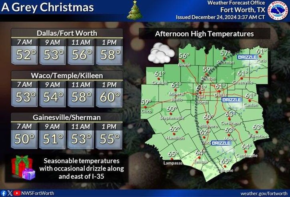
For Christmas morning, considerable cloudiness and areas of drizzle will be around. The cloud ceilings should lift somewhat by late morning. Temperature won't warm too much with highs 55° to 60°. This will all be dependent on if the sun breaks out during the afternoon. We should stay relatively rain free during the day.
 NWS
NWS
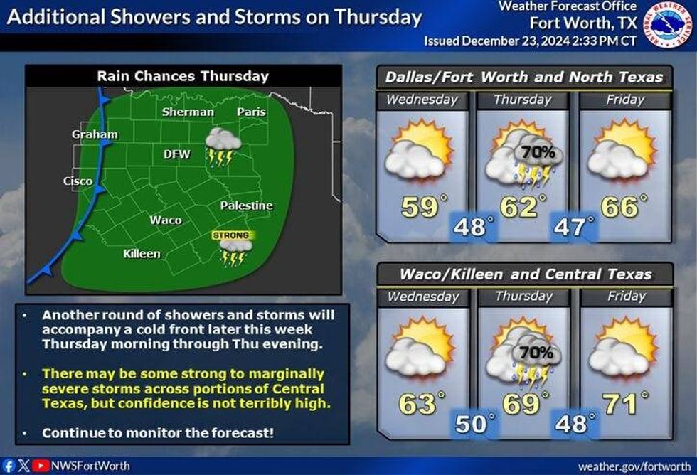
The next system will be quickly moving in on the heels of the system we're experiencing today. As of now, temperatures will be way too cool across the Dallas-Fort Worth area to see any severe thunderstorms. There will be some areas of rainbrain developing as an upper level low approaches from the west. We may get what's called dry slotted from this upper level low during the day on Thursday. This means that some pockets of chilly rain will develop to the north of highway 380 into Oklahoma.
We may miss a lot of it here in north Texas, but there will be some storms in the area containing some small hail. Another area of strong to severe storms will break out east and southeast of us by afternoon and evening. Larger hail and damaging wind will be the threats as another squall line develops and plows into Louisiana and towards the upper Texas coast late. RThere is also a very small tornado treat along the upper Texas coast.Thursday evening into Friday morning. This is all dependent on the path of the upper low. I do want to stress, I'm not overly concerned about severe weather across north Texas on Thursday, again, a different story south and east of DFW.
 NWS
NWS
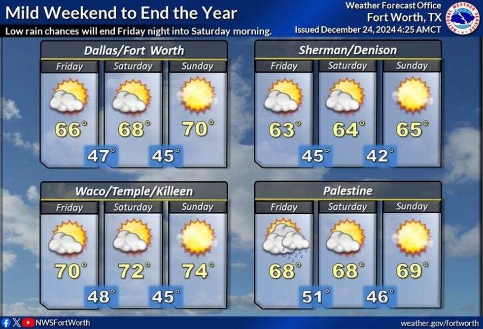
You all probably won't believe me when I tell you this, but Friday through the weekend....we warm up to or above 70°, all three days with sunshine!! It gets even warmer than that by Monday with highs approaching 80°! Yep I said 80°! The record is 90 degrees. This is the warmest high temperatures EVER in the month of December.
 NWS
NWS
Now those of you that have lived here for a long time, you know what happens when we warm up close to 80° at the end of December.. we get colder air moving in shortly after. Well, that's the weather story for next week. Below average temperatures are on the way! It's still way too early to tell you if we'll see any precipitation over-running this colder air. Stay tuned!!
7-Day Headlines:
* DFW Airport reached 68 yesterday.
* Scattered showers and strong storms today.
* Severe storms stay just south and east of DFW. Threats: Small hail and wind.
* A cloudy and cool Christmas and Hanukkah day.
* Rain returns Thursday. Severe stays east and southeast. Level 2 (slight) out of 5.
* A decent weekend ahead.
* Colder next week, starting Tuesday.
_____________________________________________________
*Yest Rain: 0.00"; Yest High: 83; Low: 55
*Today's Averages: High: 56; Low: 37
*Record high: 88 (1955); Record low: 7 (1983)
__________________________________________________________
*December Rain: 2.61"; Surplus: 0.51"
*2024 Rain: 38.36"; Surplus: 2.09"
*Sunrise: 7:28am; Sunset: 5:28pm
__________________________________________________________
Today: Cloudy and mild. Scattered showers and strong thunderstorms. Severe weather stays SE. Threats: Gusty wind and small hail. High: Mid 60s. South to NW 5-10 mph.
Christmas Eve: Cloudy, breezy and cooler. Low: 48-53. Wind: North 5 mph.
Christmas/1st day of Hanukkah: Mostly cloudy and cool. High: 55-60. Wind: NE 5 mph.
Thursday: Cloudy and cool. Scattered showers and storms return. Severe weather and heaviest rain stays east and SE of DFW. High: Low 60s.
Friday: Partly cloudy and mild. High: Near 70.
Weekend: Partly to mostly sunny and continued mild. Highs: Low 70s.
Monday: Partly cloudy and warm. High: Near 80!!! Record is 90 degrees!!
LISTEN on the Audacy App
Tell your Smart Speaker to "PLAY 1080 KRLD"
Sign Up to receive our KRLD Insider Newsletter for more news
Follow us on Facebook | Twitter | Instagram | YouTube


