


Our Texas heatwave continues through the end of the week, through the weekend, and pretty much all of the following week. I wish I had better news.
A few of you lucky ones could see if pop-up shower or storm Friday and Saturday, but right now it looks like the greatest chances will be along the Red River and points north as well as the Arklatex area.
A cold front will stall just to our north. If it sags a little bit farther south, a little bit better chance of showers and storms will enter the Metroplex, but as of now it doesn't look likely.
A strong dome of high pressure continues to grip the area, causing the temperatures to soar into the triple digits all the way through the weekend.
 National Weather Service - Fort Worth
Heat Advisories are in effect along and north of the Dallas-Fort Worth area today and tomorrow. These will most likely be extended through Friday.
We may cool down a little bit Friday-Sunday due to higher humidity levels, but I think most areas will stay in the triple digits. I see no relief from the heat through the following week as well.
*Yest Rain: 0.00; *Yest High: 104; Low: 83
*Today's Averages: High: 97; Low: 77
*Record high: 106 (1980); Record low: 63 (1965)
*July rain: 0.00"; July deficit: 1.79"
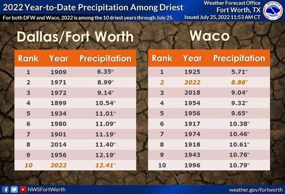
*2022 Rain: 12.41"; 2021 deficit: 9.67"
*Sunrise: 6.38am; Sunset: 8:31pm
 National Weather Service - Fort Worth
Today: *Heat Advisory* Mostly sunny and hot. High: 104. (Record 106, 1980). Wind: SouthE 10-20 mph.
Tonight: Clear and warm. Low: 78-84. Wind: South 10-20 mph.
Tomorrow: *Heat Advisory* Mostly sunny and hot! High: 104. Wind: South 10-20 mph.
Thursday: Sunny and hot. High: 104.
Friday: Partly cloudy and hot. Slight chance of a late-day storm. High: 104.
Saturday: Partly cloudy and hot. Slight chance of a late-day storm. High: 102.
Sunday: Sunny and hot. HIgh: 102.
Monday: Sunny and hot. High: 103.
LISTEN on the Audacy App
Sign Up and Follow NewsRadio 1080 KRLD


