


As we approach the final week of December in North Texas, the weather will not conform to seasonal norms, with above-average temperatures and below-average precipitation forecast until Sunday.
Good morning, and I wish you a happy Tuesday. Gentlemen, please note that you have two days remaining to complete your shopping. Fortunately, the weather will be conducive to outdoor activities for an extended period. An upper-level ridge of high pressure will continue to build over North Texas through Saturday. Additionally, individuals who suffer from Mountain Cedar or Juniper allergies should be aware that south winds at 10 to 20 mph will persist in bringing allergens from the Hill Country into North Texas. Remember to take your allergy medication in the morning and before bedtime. You will appreciate this reminder later.
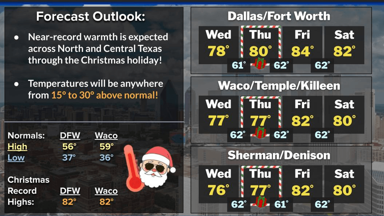
We are currently experiencing areas of low clouds and temperatures in the low to mid-60s. The average low temperature has dropped to 37 degrees, and we are currently approximately 30 degrees above average. Some areas will experience partial clearing this afternoon, with highs reaching the upper 70s. The average high temperature is currently 57 degrees, which is notably lower than our current temperatures.
The forecast for Christmas Eve, Christmas Day, through Saturday will be similar, with morning lows in the 60s and afternoon highs approaching 80 degrees on Christmas Day, low to mid-80s on Friday, and low 80s on Saturday, accompanied by morning clouds and afternoon sun.
A cold front is expected to pass through our area on Sunday morning, bringing a slight chance of rain. Most areas will remain dry, and the afternoon high on Sunday will occur during the morning hours, with temperatures in the mid-60s. Temperatures will gradually decline throughout the day, reaching the 50s, with north winds gusting up to 25 mph. There may be lingering drizzle throughout the day, with limited sunshine.
Skies will remain cloudy on Monday, with morning lows in the low 40s,and daytime highs only near 50. Although temperatures will finally be below average, this will not last long. Temperatures will begin to rise starting Tuesday and continue throughout the week, leading up to New Year's.
That concludes your 7-day forecast. I wish you a great day today, and I encourage you to complete your shopping and enjoy the weather when you can, it's the only weather you've got.
7-Day Headlines:
* DFW Airport reached 75 yesterday.
* Morning clouds, afternoon sun through Saturday.
* Above average temperatures/below average temperatures through Saturday.
* Mountain Cedar pollen high all week.
* Flirting with record highs Friday and Saturday.
* No weather travel delays across the 5-state area.
* Next cold front early Sunday. Slight rain chance. Colder.
*Yest Rain: 0.00"; Yest High: 75; Low: 53
*Today's Averages: High: 56; Low: 37
*Record high: 81 (1955, 1964); Record low: -1 (1989)
*December Rain: 0.08"; Deficit:
*2025 Rain: 38.31"; Surplus: +2.13"
*Sunrise: 7:28am; Sunset: 5:28pm
Tuesday: Morning clouds, afternoon sun. Breezy and warm. High: Upper 70s. Wind: South 10-20 mph.
Tuesday night: Partly cloudy and mild. Low: Mid 60s. Wind: South 10-15 mph.
Wednesday: Morning clouds, afternoon sun. Breezy, and very mild. High: Upper 70s. Wind: South 10-20 mph.
Christmas Eve: Partly cloudy, breezy, and humid. Low: Low to mid 60s.
Christmas Day: Morning clouds, afternoon sun. High: Near 80.
Friday and Saturday: Morning clouds, afternoon sun. Breezy, and warm. High: Low 80s.
Sunday: Morning cold front. Slight rain chance. Cloudy, breezy and colder. High: Mid 60s early, falling into the low 50s by dinner time.
Monday: Cloudy and chilly. High: Near 50.
LISTEN on the Audacy App
Tell your Smart Speaker to "PLAY 1080 KRLD"
Sign Up to receive our KRLD Insider Newsletter for more news
Follow us on Facebook | Twitter | Instagram | YouTube


