After some overnight rain and small hail, our weather is expected to improve into the weekend. However, as we draw closer to spring, severe weather season is imminent. Notably, Meteorological Spring commences on Saturday.
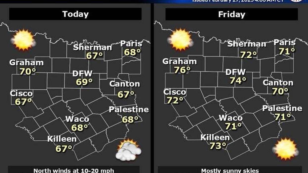
Some of you were fortunate enough to receive welcome rain overnight. Unfortunately, only 0.01 inches of rain were recorded at DFW Airport, whereas others received over half an inch. Clouds are lingering behind the front this morning, but I anticipate decreasing clouds from north to south throughout the morning. Temperatures are initially in the upper 40s to low 50s, necessitating a light jacket. Today promises to be sunny and beautiful, with highs reaching the upper 60s. Enjoy the day.
Clear skies and calm winds will facilitate radiational cooling tonight. Consequently, jackets will be necessary when you wake up tomorrow morning, as readings are expected to drop into the upper 30s to low 40s. Tomorrow will be sunny and ideal for activities like golf or bike riding, with high temperatures reaching the mid-70s.
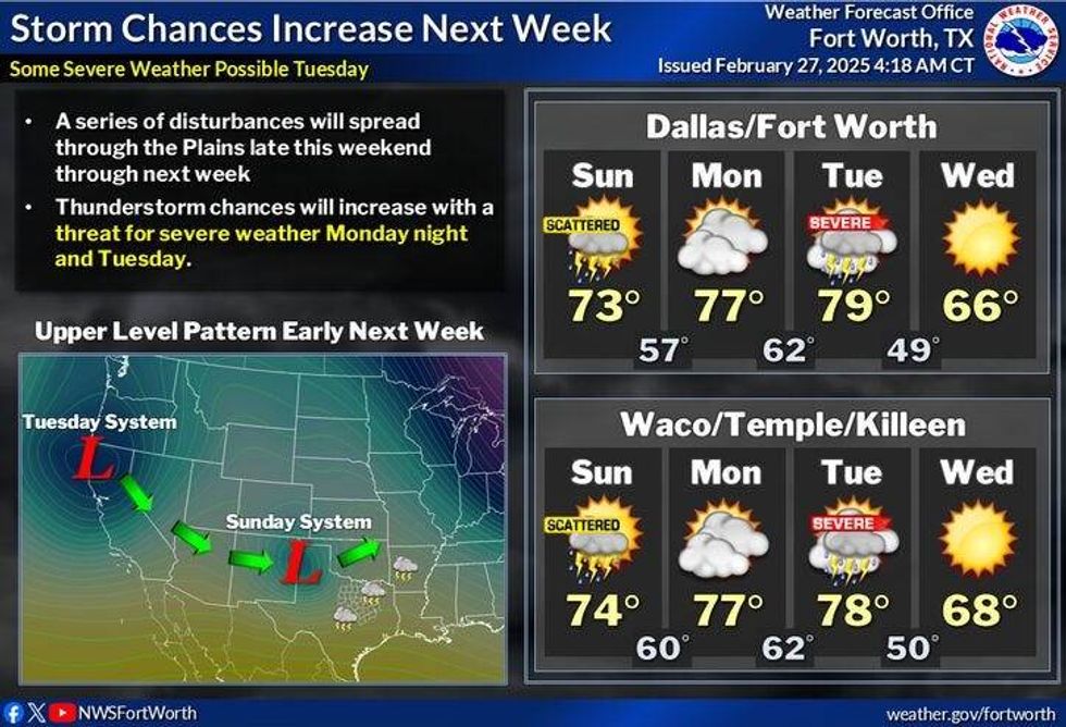
Most of the weekend is expected to be decent until Sunday evening, when I anticipate our next chance for scattered showers and storms, some of which may be strong. Before then, plenty of sunshine will dominate, with highs in the mid-70s on Saturday and upper 70s on Sunday.
On Monday, we will be between storm systems, with morning clouds and afternoon sun. Most areas are expected to approach the 80-degree mark again.
 NWS
NWS
By Monday night into the first half of Tuesday, a powerful storm system will move through the area, bringing showers and storms, some of which may be severe. One favorable aspect of this system is that the storms will pass through before peak heating, A different story in Dixie. I will continue to monitor the timing of this next system and update my forecast accordingly.
Afternoon highs on Tuesday are expected to reach the mid-to-upper 70s. On Wednesday, winds will shift to the north, ushering in much cooler air, with gusts up to 30 mph. Afternoon highs will only reach around 60 degrees.
Please note that our average last freeze in North Texas is March 12th, so it is premature to plant your gardens. In fact, it would be prudent to wait until after Easter to do so, when the mesquite trees have budded.
7-Day Headlines:
* DFW Airport reached 81 yesterday.
* Above average temperatures continue.
* Cool mornings, mild afternoons.
* Most of the weekend looks OK.
* Watching for strong storms late Sunday and Tuesday morning.
* Highs pushing 80 degrees Sunday and Monday.
* Stonger cold front by next Wednesday.
_____________________________
*Yest Rain: 0.01"; Yest High: 81; Low: 56
*Today's Averages: High: 64; Low: 43
*Record high: 85 (1918); Record low: 19 (2002)
______________________________
*February Rain: 1.34"; Deficit:
*2025 Rain: 7:03"; Surplus: 1.98"
*Sunrise: 6:58am; Sunset: 6:24pm
______________________________
Today: Morning clouds, afternoon sun. High: Upper 60s. Wind: North 10-15 mph.
Tonight: Clear and chilly. Low: 38-42. Wind: Lt. Var.
Tomorrow: Sunny and perfect! High: Mid 70s. Wind: SW 5-10 mph.
Saturday: Mostly sunny, continued nice. High: Mid 70s.
Sunday: Increasing clouds late. Chance for showers and storms towards evening. High: Mid to upper 70s.
Monday: Back to sunshine, breezy and warm. High: Near 80.
Tuesday: Morning showers and storms, some severe, then mostly sunny, windy and mild. High: Mid to upper 70s.
Wednesday: Sunny, windy and cooler. High: Near 60.
LISTEN on the Audacy App
Tell your Smart Speaker to "PLAY 1080 KRLD"
Sign Up to receive our KRLD Insider Newsletter for more news
Follow us on Facebook | Twitter | Instagram | YouTube