Tomorrow is the first official day of fall, but unfortunately it won't feel like it until early next week.
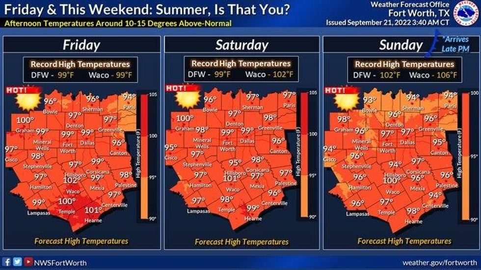
That stubborn area of high pressure in the upper levels will continue to grip the area through the weekend. Will be flirting with a record high today with readings in the upper 90s. The record today is 99°. We'll flirt with another record high tomorrow with a high approaching 100°. The record is 101°.
A weak cold front will back into the area late Thursday evening dropping temperatures into the low to mid-90s on Friday. This front drifts back to the north late Friday keeping us hot into the weekend. Afternoon highs both Saturday and Sunday will be in the upper 90s again.
 National Weather Service - Fort worth
A decent cold front will slip through the area late Sunday night, bringing a very slight chance of a shower storm with it. Right now the coverage area for rain is at 4.7%.
Windy and cooler weather will dominate Monday and Tuesday with lows in the 50s and 60s, afternoon highs in the low to mid 80s on Monday, mid 80s on Tuesday, with a breezy north wind, lower humidity and plenty of sunshine..
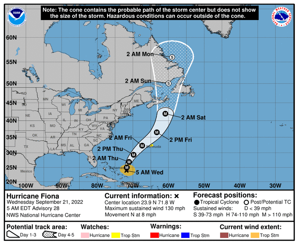
Quick update on the tropics: Hurricane Fiona is now a category 4 hurricane over the open water of the western Atlantic. Wind as of 5:00 a.m. is at 130 mph! Its movement is north at 8 mph. Bermuda needs to keep a close eye on this one as it will skirt the island just to the west as a major hurricane on Friday.
 NOAA
NOAA
There's another system approaching the windward Islands in the eastern Caribbean over the next 48 hours. This storm is not named right now, but will soon become T.S.Hermine. Residents across the Gulf Coast and Mid-Atlantic States need to keep an eye on this storm by the middle to end of next week. Stay tuned for updates over the coming days.
*Yest Rain: 0.00"; High: 96; Low: 77
*Today's Averages: High: 87; Low: 67
*Record high: 99 (1956, 2005); Record low: 45 (1983)
*September rain: 0.33"; September deficit: 1.59"
*2022 Rain: 23.42"; 2022 deficit: 3.05"
*Sunrise: 7:16; Sunset: 7:25am
Today: *Air Quality Alert* Sunny and hot. Near record (99 degrees) heat. High: Upper 90s. Wind: SE 5-10 mph.
Tonight: Clear and stuffy. Lows: Low to mid 70s. Wind: SE 5-10 mph.
Thursday / First day of Fall: Mostly sunny and hot. Near record (101 degrees) heat. High: Upper 90s. Wind: SSE 5-10 mph.
Friday - Sunday: Mostly sunny and hot. High: Mid to upper 90s.
Monday: Sunny, breezy and cooler. Low humidity. High: Low to mid 80s.
Tuesday: Sunny and pleasant. High: Mid 80s.

LISTEN on the Audacy App
Tell your Smart Speaker to "PLAY 1080 KRLD"
Sign Up and Follow NewsRadio 1080 KRLD