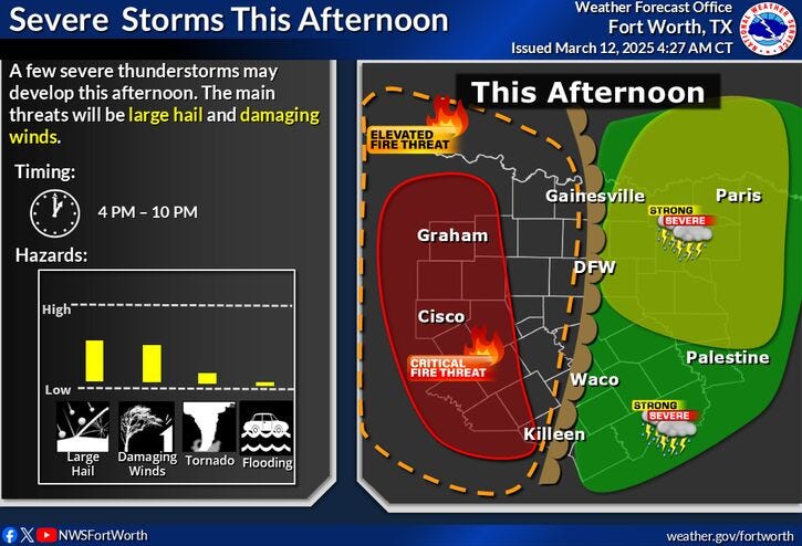
Hail and strong winds are the primary threats across North Texas as a system capable of producing severe storms moves through Wednesday evening. An isolated tornado can't be ruled out, and the system is expected to intensify as it moves east of Dallas-Fort Worth.
Temperatures fell into the 50s on Wednesday morning. However, this will change later in the afternoon and evening as a strong upper-level disturbance moves across Oklahoma. At the same time, the dry line will surge out of West Texas, arriving late Wednesday afternoon and producing isolated strong storms, especially in the Mid Cities and points east. A few of these storms may become severe, particularly in Collin, Dallas, Ellis, Kaufman, and Rockwall counties shortly after dinner time. These storms will be capable of producing all modes of severe weather. Highs today will be near 80 degrees.
After Wednesday evening, the forecast is clear, with beautiful weather dominating North Texas into the weekend and at least the middle of next week. Temperatures on Thursday will reach the low to mid-80s, almost 20 degrees above average for this time of year. The average high is 67 degrees.
Friday looks uneventful, with the exception of 50 mph wind gusts coming in from the west, creating a critical grass fire danger not just in North Texas but across the western two-thirds of the state. Afternoon highs will reach near 80 degrees.
This will lead to a great weekend to wash your vehicle and get those lawns mowed for the first time. Afternoon highs will be cooler, with readings in the mid-60s on Saturday and low 70s on Sunday, while morning lows will dip into the 40s.
The first couple of days of next week will be uneventful as well, with plenty of sunshine and highs creeping back into the mid-80s by Monday and low 80s on Tuesday.
LISTEN on the Audacy App
Tell your Smart Speaker to "PLAY 1080 KRLD"
Sign Up to receive our KRLD Insider Newsletter for more news
Follow us on Facebook | Twitter | Instagram | YouTube
