


It's the last full day of spring y'all! A few tropical showers today and tomorrow, otherwise we're back to a sunny and hot weather pattern this weekend into early next week.
We're waking up this morning to a mainly clear sky, but clouds will rapidly increase through the day as a ton of moisture continues to stream north off of the Gulf of Mexico. We still do not have a named storm in the Western Gulf, but the Hurricane Center is giving it a very high chance of becoming a brief tropical storm. If this happens, it will be called Alberto. It will be spreading a ton of rain to areas along and south of Interstate 10 over the next 36 to 48 hours. This is where Flood Watches are in effect. We'll see little to no effect from this storm except for a lot more cloud cover over the next 36 hours. Most will stay dry. The clouds will keep the temperatures down today with highs in the upper 80s. Near 90 for tomorrow.
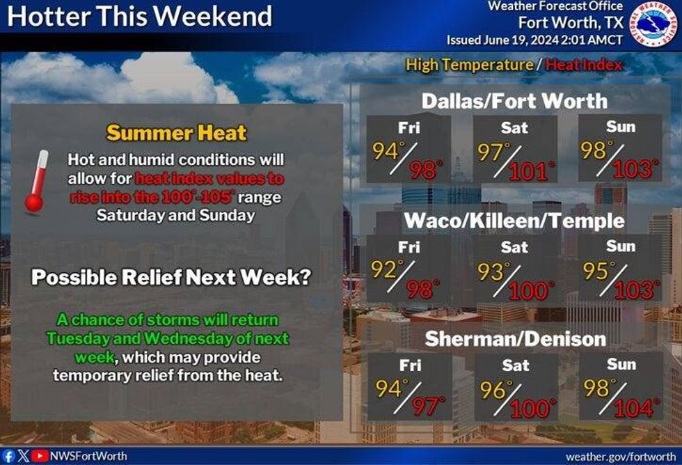
By Friday into the weekend, the upper level ridge of high pressure that's been across the northeastern third of the U.S. will back-build across Texas this weekend, shutting off any hope for rain through early next week. Afternoon highs will reach the mid 90s this weekend, mid to upper 90s Monday and Tuesday. Afternoon humidity levels won't be too bad so the heat index will be near100°. It could be worse, right?
 NWS
NWS
There are signs of a possible pattern change by the middle to end of next week. It's called a northwesterly flow event. This is where storms form in eastern Colorado and western Kansas during the late afternoon hours, expand and slide SE towards north Texas through the early morning hours. I'll keep an eye on this possible pattern change, but it's still over a week away and is subject to change.
Have a terrific day today and please enjoy the weather when you can, it's the only weather you've got.
_____________
7-Day Headlines:
* DFW Airport reached 92 yesterday.
* Watching the Gulf of Mexico for our first named storm, "ALBERTO".
* Flooding rain south of I-10 through tomorrow.
* Tropical Storm Warnings from San Louis Pass to Brownsville.
* A bit cooler for a short today.
* Heating up this weekend into this week.
__________________________________________________________
*Yest Rain: 0.00"; Yest High: 92; Low: 73
*Today's Averages: High: 92; Low: 73
*Record high: 103 (1980); Record low: 56 (1912)
__________________________________________________________
*June Rain: 3.67"; Surplus: 1.38"
*2024 Rain: 28.74"; Surplus: 9.86"
*Sunrise: 6:20am; Sunset: 8:39pm
__________________________________________________________
Today: Increasing clouds, breezy, humid and warm. Isolated late-day tropical showers. Greater chances south and east of DFW. High: Upper 80s. Heat index: Mid 90s. Wind: East 15-25 mph.
Tonight: Cloudy, breezy and muggy. Isolated tropical showers. Low: Mid 70s. Wind: East 10-20 mph.
Tomorrow: **First day of Summer (3:50pm)** Mostly cloudy, breezy and humid. Isolated tropical showers. High: Near 90. Heat index: Mid 90s. Wind: East 10-20 mph.
Friday: Partly cloudy, hot and humid. Isolated late-day tropical showers. High: Low 90s.
Weekend: Mostly sunny, hot and humid. Highs: Mid 90s. Heat index: 102 degrees.
Monday and Tuesday: Sunny and hot. High: Mid to upper 90s. Heat index: 102 degrees.
LISTEN on the Audacy App
Tell your Smart Speaker to "PLAY 1080 KRLD"
Sign Up to receive our KRLD Insider Newsletter for more news
Follow us on Facebook | Twitter | Instagram | YouTube


